Three-dimensional-terrain-based dynamic visualization method for wind

A three-dimensional terrain and terrain technology, applied in climate sustainability, image data processing, 3D modeling, etc., can solve difficult wind direction and speed, lack of intuition, emergency decision-making, wind farm site selection and other application difficulties and other problems to achieve the effect of simple input and scalability

Active Publication Date: 2017-09-15
FUZHOU UNIV
View PDF6 Cites 20 Cited by
  • Summary
  • Abstract
  • Description
  • Claims
  • Application Information

AI Technical Summary

Problems solved by technology

However, there are few patents on how to efficiently and intuitively display the dynamic effects of wind speed and wind direction in a virtual geographic environment
Numerical simulation of wind farms is important, but there is a lack of corresponding visualization solutions. It is difficult to grasp the direction and speed of wind from a large number of data. difficulty

Method used


Image

  • Three-dimensional-terrain-based dynamic visualization method for wind
  • Three-dimensional-terrain-based dynamic visualization method for wind
  • Three-dimensional-terrain-based dynamic visualization method for wind

Examples


Embodiment Construction

[0049] The present invention will be further described below in conjunction with the accompanying drawings and embodiments.

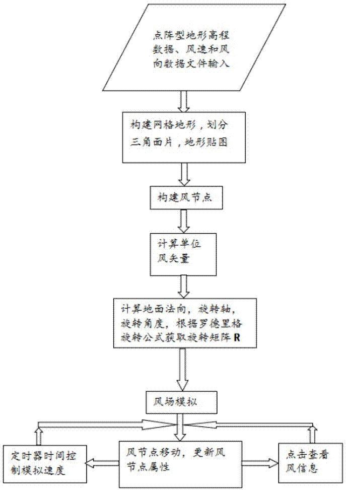
[0050] Please refer to figure 1 , the present invention provides a dynamic visualization method of wind based on three-dimensional topography, generally including: data input and virtual scene construction, three-dimensional wind vector field construction and dynamic wind field display three parts;

[0051] The input content and requirements of the data are as follows: the input data includes terrain elevation data, wind speed and wind direction data files, and these three data should all contain the same public information: longitude, latitude, row number, column number, row number in the lower left corner Spacing and column spacing. The accuracy of the input files used is not limited. If the accuracy is doubled, the amount of data and calculations in one file will be increased by 4 times, and the amount of data to be processed will be increased by 12...


PUM


Abstract

The invention relates to a three-dimensional-terrain-based dynamic visualization method for wind. The method comprises steps of data inputting and virtual scene construction, three-dimensional wind vector field construction, and dynamic wind field displaying. To be specific, dot-matrix type terrain elevation, wind speed and wind direction data files are inputted; a three-dimensional grid terrain is constructed; a wind node is constructed and a wind node direction is initialized; a wind node parallel to an XY plane is rotated to enable the node to express a correct two-dimensional wind direction, a terrain normal vector is calculated, and a rotation matrix R is obtained; a unit three-dimensional wind vector is calculated and the calculated vector is multiplied by a wind speed to obtain a next position point; when the wind node moves to the next position point, the wind vector, the rotation matrix R, the color, and the size of the wind node are updated; and when the wind node is located at an end position, the wind node moves to a starting position at a next step. Therefore, wind flowing at a three-dimensional terrain is simulated dynamically at a computer under the circumstance that the wind speed and wind direction data of a study region are calculated by inputted elevation data and wind field calculation models.

Description

technical field [0001] The invention relates to a dynamic visualization method of wind based on three-dimensional topography. Background technique [0002] The invention relates to a method for dynamically visually displaying predicted and calculated wind direction and wind speed data on a three-dimensional terrain constructed in a computer according to real scenes. This method not only helps to intuitively obtain the overall wind direction in the study area, but also grasps the speed and direction of the wind on the undulating terrain at a smaller scale and with higher precision, for example, the wind in a 30m*30m grid size and direction. This intuitive method of displaying the wind speed and direction of the wind field can not only be used in industrial fields such as wind power generation management and site selection, forest fire auxiliary decision-making, pollution source diffusion control, but also in the display of wind effects in movies and games. [0003] At prese...

Claims


Application Information

Patent Timeline
Patent Type & Authority Applications(China)
IPC IPC(8): G06T17/05G06T17/20
CPCG06T17/05G06T17/20G06T2210/61Y02A90/10
Inventor 李建微胡奎李晓雯陈思喜罗永珍
Owner FUZHOU UNIV
Why Eureka
Try Eureka