Large wildlife population number investigation method based on aerial photography of unmanned aerial vehicle

A wild animal and UAV technology, applied in the field of aerial image target recognition and statistics, can solve the problems of low precision, animal interference, high cost, etc., and achieve the effect of improving speed and accuracy, strong repeatability and wide detection distance

Inactive Publication Date: 2017-09-22
INST OF GEOGRAPHICAL SCI & NATURAL RESOURCE RES CAS
View PDF3 Cites 9 Cited by
  • Summary
  • Abstract
  • Description
  • Claims
  • Application Information

AI Technical Summary

Problems solved by technology

However, due to the low natural density and inaccessibility of large wild animals, the traditional ground-based survey methods have certain interference to animals, and there are problems such as line of sight occlusion and high cost. Difficult to repeat
[0004] In recent years, drones have been widely used in fields such as precision agriculture and environmental monitoring due to their advantages of low cost and flexible operation. Its efficiency and accuracy in wildlife surveys

Method used


Image

  • Large wildlife population number investigation method based on aerial photography of unmanned aerial vehicle
  • Large wildlife population number investigation method based on aerial photography of unmanned aerial vehicle
  • Large wildlife population number investigation method based on aerial photography of unmanned aerial vehicle

Examples


Embodiment Construction

[0031] The technical solution of the present invention will be further described below in conjunction with the accompanying drawings.

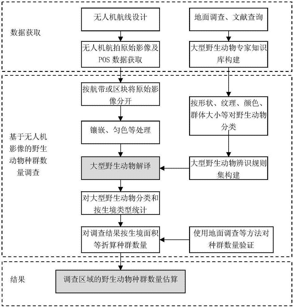
[0032] as attached figure 1 As shown, a kind of large wild animal population quantity investigation method based on unmanned aerial vehicle aerial photography of the present invention is characterized in that, comprises the following steps:

[0033] 1) According to the "National Terrestrial Wildlife Resources Survey and Monitoring Technical Regulations" published by the State Forestry Administration, determine the sampling survey intensity of the survey area, determine the coverage of the aerial photography of the drone through the sampling survey intensity, and plan the flight route of the drone. aerial photography.

[0034] When the survey area is small, the air route can be designed to cover the entire area; when the survey area is large, the air belt can be designed by sampling survey. Since the scope of wild animal surveys is usually do...


PUM


Abstract

The invention provides a large wildlife population number investigation method based on aerial photography of an unmanned aerial vehicle. The method is characterized by comprising the following steps: 1) determining sampling strength according to the Technical Regulations for Investigation and Monitoring of Terrestrial Wildlife Resources in China published by the State Forestry Administration, and planning a flight route of the unmanned aerial vehicle for aerial photography; 2) splicing aerial photography images of the unmanned aerial vehicle to form a spliced image for sampling investigation survey strip; 3) constructing a large wildlife interpretation expert knowledge base of an investigation area, and interpreting the spliced image of the sampling investigation survey strip to form an investigation result of the sampling investigation survey strip; and 4) performing proportional conversion on the investigation result within the investigation range represented by the spliced image of the sampling investigation survey strip to obtain the whole investigation range, and then verifying the conversion result by using the population number results obtained by ground investigation, document query and other methods to accomplish the estimation of the large wildlife population number in the estimation area.

Description

technical field [0001] The invention belongs to the technical field of aerial image target recognition and statistics, and in particular relates to a method for investigating the population of large wild animals based on aerial photography of an unmanned aerial vehicle. Background technique [0002] Historical experience shows that establishing nature reserves and national parks is one of the best ways to protect wild animals and their habitats and prevent species extinction (Guan Bo, 2012). Since the United States established the world's first national park - Yellowstone Park in 1872, Canada, New Zealand, the United Kingdom, France, Germany and other countries have successively established many national parks. In order to protect wild animals and their habitat resources, my country has successively established 428 national nature reserves (Tang Fanglin, 2015). In order to further strengthen the protection of the authenticity and integrity of natural ecosystems and natural ...

Claims


Application Information

Patent Timeline
Patent Type & Authority Applications(China)
IPC IPC(8): G06T3/40G06K9/00G06N5/02
CPCG06N5/022G06T3/4038G06V20/13
Inventor 邵全琴王东亮曹巍李愈哲樊江文
Owner INST OF GEOGRAPHICAL SCI & NATURAL RESOURCE RES CAS
Why Eureka
Try Eureka