Remote sensing image coast line information extraction method and system based on tasseled cap transformation

A tasseled cap transformation and remote sensing image technology, applied in the field of remote sensing image processing, can solve problems such as the failure of water body information extraction methods, and achieve the effect of improving computing efficiency and result accuracy

Active Publication Date: 2017-10-13
舟山市普陀区启迪海洋科技产业研究院
View PDF3 Cites 6 Cited by
  • Summary
  • Abstract
  • Description
  • Claims
  • Application Information

AI Technical Summary

Problems solved by technology

[0006] Considering the influence of suspended sediment content on the spectral characteristics of water bodies, which leads to the failure of traditional water body information extraction methods, affects the coastline information extraction effect, and the actual shape changes of coastlines, explore a remote sensing image coastline information extraction method and system based on tasseled cap transformation. In order to meet the challenges in the field of remote sensing image processing and ensure the accuracy of coastline information extraction, it has become an urgent problem to be solved

Method used


Image

  • Remote sensing image coast line information extraction method and system based on tasseled cap transformation
  • Remote sensing image coast line information extraction method and system based on tasseled cap transformation
  • Remote sensing image coast line information extraction method and system based on tasseled cap transformation

Examples


Embodiment

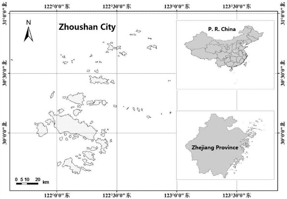
[0122] In this example, the main island of Zhoushan City and its surrounding areas are selected as the research area, and application tests are carried out to evaluate the effectiveness of the method and the accuracy of the results.

[0123] Overview of the study area, Zhoushan City is located in the northeast of Zhejiang Province, facing the East China Sea in the east, Hangzhou Bay in the west, and Shanghai in the north. The location map is as image 3 shown.

[0124] Zhoushan City is my country's first prefecture-level city organized by an archipelago, including 1390 islands. Its geographical location is between 121°30′-123°25′ east longitude and 29°32′-31°04′ north latitude. 182 kilometers long and 169 kilometers wide from north to south. On June 30, 2011, the State Council officially approved the establishment of Zhejiang Zhoushan Islands New District, which is also the first national-level new district with the theme of marine economy in the country. The main island of ...


PUM


Abstract

The invention discloses a remote sensing image coast line information extraction method and system based on tasseled cap transformation. The method comprises steps that pre-processing, radiation calibration and atmosphere correction for a remote sensing image are carried out to acquire a pre-processing image of a research area; water body information extraction based on tasseled cap transformation, tasseled cap transformation of the pre-processing image is carried out to extract the humidity information, the initial water body information is acquired based on threshold segmentation, and the accurate water body information is acquired through utilizing mathematics morphological operation; coast line information extraction based on characteristic knowledge, the accurate water body information is vectorized, and final coast line information extraction is carried out; and precision evaluation, space superposition analysis on the coast line information extraction result and an original image is carried out, and the result is evaluated from aspects of position accuracy and coast line integrity. The method is advantaged in that the method is suitable for coast line information extraction of areas having relatively large suspended sediment concentrations, operation is simple, and the result is accurate.

Description

technical field [0001] The invention relates to the technical field of remote sensing image processing, in particular to a method and system for extracting coastline information from remote sensing images based on tasseled cap transformation. Background technique [0002] The coastline is the boundary line between land and sea, and also the baseline for dividing sea and land management areas. In my country, it refers to the actual trace line formed during the average spring tide and high tide for many years. Coastline is not only an important land resource, but also an important basic geographic information data. Coastlines are constantly changing due to sea level rise caused by natural conditions such as estuary siltation and climate warming, and human activities such as land reclamation, land reclamation, and marine engineering. Therefore, it is of great significance to quickly and accurately determine the dynamic changes of the coastline for the management of sea area us...

Claims


Application Information

Patent Timeline
Patent Type & Authority Applications(China)
IPC IPC(8): G06K9/00G06K9/46G06T7/136
CPCG06T7/136G06T2207/10032G06V20/182G06V10/44
Inventor 陈超傅姣琪张帅
Owner 舟山市普陀区启迪海洋科技产业研究院
Why Eureka
Try Eureka