
Remote-sensing inversion method and system for primary productivity of Shenzhen marine sites

A primary productivity and remote sensing inversion technology, which is applied in resources, instruments, climate sustainability, etc., can solve the problems of the lack of NPP remote sensing inversion technology methods, the difficulty in estimating ocean net primary productivity, and the unsatisfactory applicable scale of remote sensing inversion methods, etc. question

Active Publication Date: 2017-10-13
SHENZHEN INST OF ADVANCED TECH
View PDF5 Cites 8 Cited by
  • Summary
  • Abstract
  • Description
  • Claims
  • Application Information

AI Technical Summary

Problems solved by technology

[0004] Most of the existing methods use traditional on-site measurement methods to study marine net primary productivity, and their research scales are mostly locked in local bays such as Daya Bay. Sampling takes a long time and it is difficult to achieve large-scale sampling; In order to solve the problem of the efficiency of the method, some new technical methods have emerged, such as using remote sensing data to invert ocean net primary productivity, although these remote sensing inversion techniques have better time continuity and are convenient for analyzing the distribution of ocean net primary productivity in large-scale space However, the applicable scale of remote sensing inversion methods headed by the VGPM model is often unsatisfactory, and it is often difficult to obtain good results when faced with small-scale offshore waters. Sea areas may also face differences in remote sensing inversion. In addition, it is difficult to estimate long-term ocean net primary productivity. There are many parameters involved in the calculation, and the model is very complicated. However, existing technologies have certain limitations
Based on the above reasons, similar techniques and methods in the past mostly chose the East China Sea, Taihu Lake, and the Pearl River Estuary as the main research areas, while there are few related NPP remote sensing inversion techniques and methods for Shenzhen's coastal waters

Method used


Image

  • Remote-sensing inversion method and system for primary productivity of Shenzhen marine sites
  • Remote-sensing inversion method and system for primary productivity of Shenzhen marine sites
  • Remote-sensing inversion method and system for primary productivity of Shenzhen marine sites

Examples


Embodiment Construction

[0041] The present invention will be described in further detail below in conjunction with the accompanying drawings and specific embodiments.

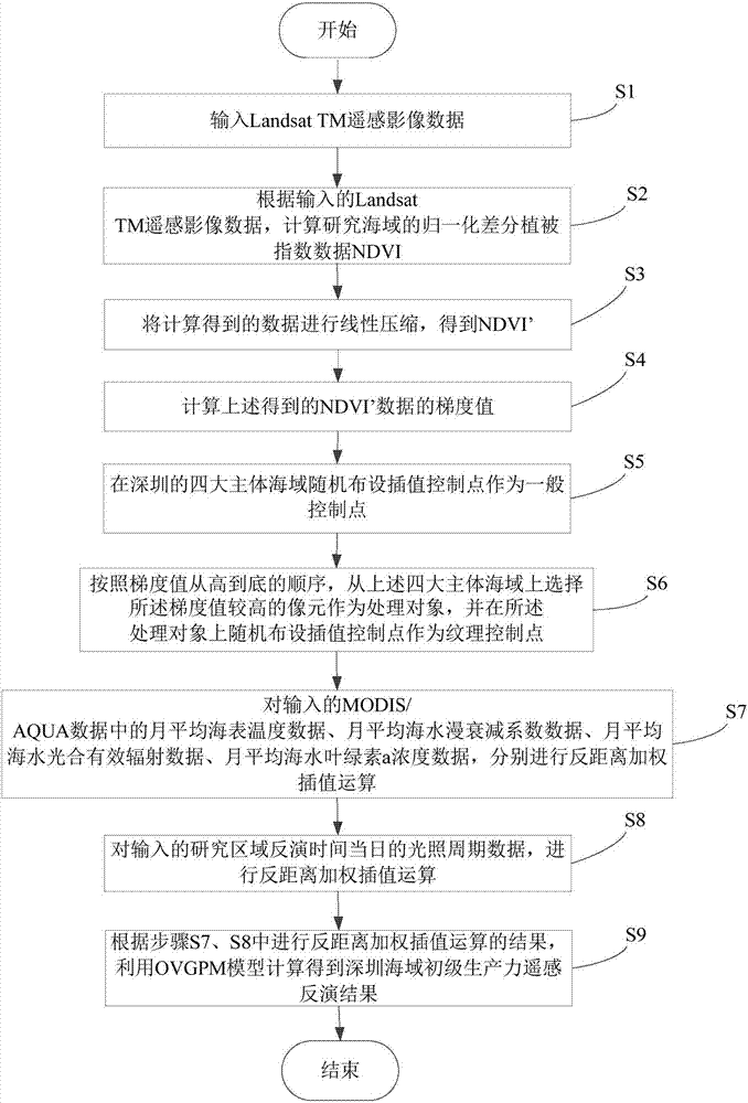
[0042] refer to figure 1 As shown, it is the operation flowchart of a preferred embodiment of the remote sensing inversion method for primary productivity in Shenzhen sea area of ​​the present invention.

[0043] Step S1, input Landsat TM remote sensing image data. in:

[0044] The Landsat TM remote sensing image data includes 7 spectral segments, namely: 3 visible spectral segments, 1 near-infrared spectral segment, 2 near-short-wave infrared spectral segments, 1 thermal infrared spectral segment, and the 3 visible spectral segments The segments include: blue-green spectrum, green spectrum, and red spectrum; and the 7 spectrum segments are named in turn: B 1 (blue-green band), B 2 (green band), B 3 (red band), B 4 (near-infrared spectrum), B 5 (near short-wave infrared spectrum), B 6 (thermal infrared spectrum), B 7 (near sh...


PUM


Abstract

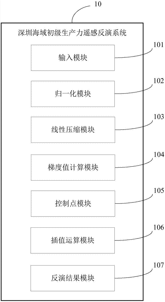
The invention relates to a remote-sensing inversion method for primary productivity of Shenzhen marine sites. The method comprises that Landsat TM remote-sensing image data is input; normalized difference vegetation index (NDVI) data of the Shenzhen marine sites is calculated; the NDVI data is compressed linearly to obtain NDVI'; a gradient value nablag of the obtained NDVI' data is calculated; interpolation control points are laid in the four main Shenzhen marine sites randomly and serve as common control points; a pixel of a higher nablag value is selected from the four main Shenzhen marine sites and serves as a processing object deltap, and interpolation control points are laid in the deltap randomly and serve as texture control points; inverse-distance weighted interpolation operation is carried out on data in MODIS / AQUA; photoperiod data of the Shenzhen sites in the present day is inversed, and inverse-distance weighted interpolation operation is carried out; and an OVGPM model is used to obtain a remote-sensing inversion result of the primary productivity of the Shenzhen oscean sites by calculation. The invention also relates to a remote-sensing inversion system for the primary productivity of the Shenzhen marine sites. Thus, the primary productivity of the Shenzhen marine sites can be inversed in a more accurate, simpler and rapider way.

Description

technical field [0001] The invention relates to a remote sensing inversion method and system for primary productivity in the sea area of ​​Shenzhen. Background technique [0002] Shenzhen is located on the southern coast of Guangdong Province, with a land area of ​​22°26'59" - 22°51'49"N, 113°45'44" - 114°37'21", facing Daya Bay and Dapeng Bay in the east , facing the Pearl River Estuary and Lingdingyang in the west, facing Hong Kong across the Shenzhen River in the south, and bordering Dongguan and Huizhou in the north; the sea area connects the South China Sea and the Pacific Ocean, and is mainly divided into four sea areas: the Pearl River Estuary, Shenzhen Bay, Dapeng Bay and Daya Bay. It is 257 kilometers long and has a sea area of ​​1145 square kilometers. It belongs to the subtropical marine monsoon climate. The annual average surface water temperature in the coastal sea area is 18-28°C. The main pollutants in the coastal sea area are petroleum, inorganic nitrogen an...

Claims


Application Information

Patent Timeline
IPC IPC(8): G06K9/00G06Q10/06
CPCG06Q10/0639G06V20/13Y02A90/10
Inventor 韩宇陈劲松张彦南王久娟易琳姜小砾
Owner SHENZHEN INST OF ADVANCED TECH
Learn More