
Underground illegal mining identification method and system integrated with D-InSAR and GIS technology

An identification system and illegal technology, applied in radio wave measurement system, radio wave reflection/re-radiation, utilization of re-radiation, etc., can solve the lack of timing of mining subsidence space-time analysis, can not fully reflect the advantages of spatial analysis and visual expression, etc. question

Inactive Publication Date: 2017-10-20
EAST CHINA UNIV OF TECH +1
View PDF6 Cites 18 Cited by
  • Summary
  • Abstract
  • Description
  • Claims
  • Application Information

AI Technical Summary

Problems solved by technology

According to the deformation characteristics of mining subsidence, an underground mining monitoring system based on D-InSAR has been proposed, which can extract the surface deformation area caused by underground mining from the mining area, and mask the legal mining area from the mining area. Distinguishing illegal mining incidents has a good monitoring effect, but lacks the timing of mining subsidence spatio-temporal analysis, cannot fully reflect the advantages of the system's spatial analysis and visual expression, and requires staff to have high spatial data processing capabilities
[0007] After the underground coal seam is mined, the overlying rock stratum and the surface will move and deform. Using InSAR technology to monitor the continuous surface movement and deformation law can grasp the mining degree of the underground coal seam and identify underground mining behavior, but it will take time Serial SAR data support and selection of appropriate interferometric methods

Method used


Image

  • Underground illegal mining identification method and system integrated with D-InSAR and GIS technology
  • Underground illegal mining identification method and system integrated with D-InSAR and GIS technology
  • Underground illegal mining identification method and system integrated with D-InSAR and GIS technology

Examples


Embodiment

[0071] The embodiment of the present invention provides an underground illegal mining identification system integrating D-InSAR and GIS technology, including

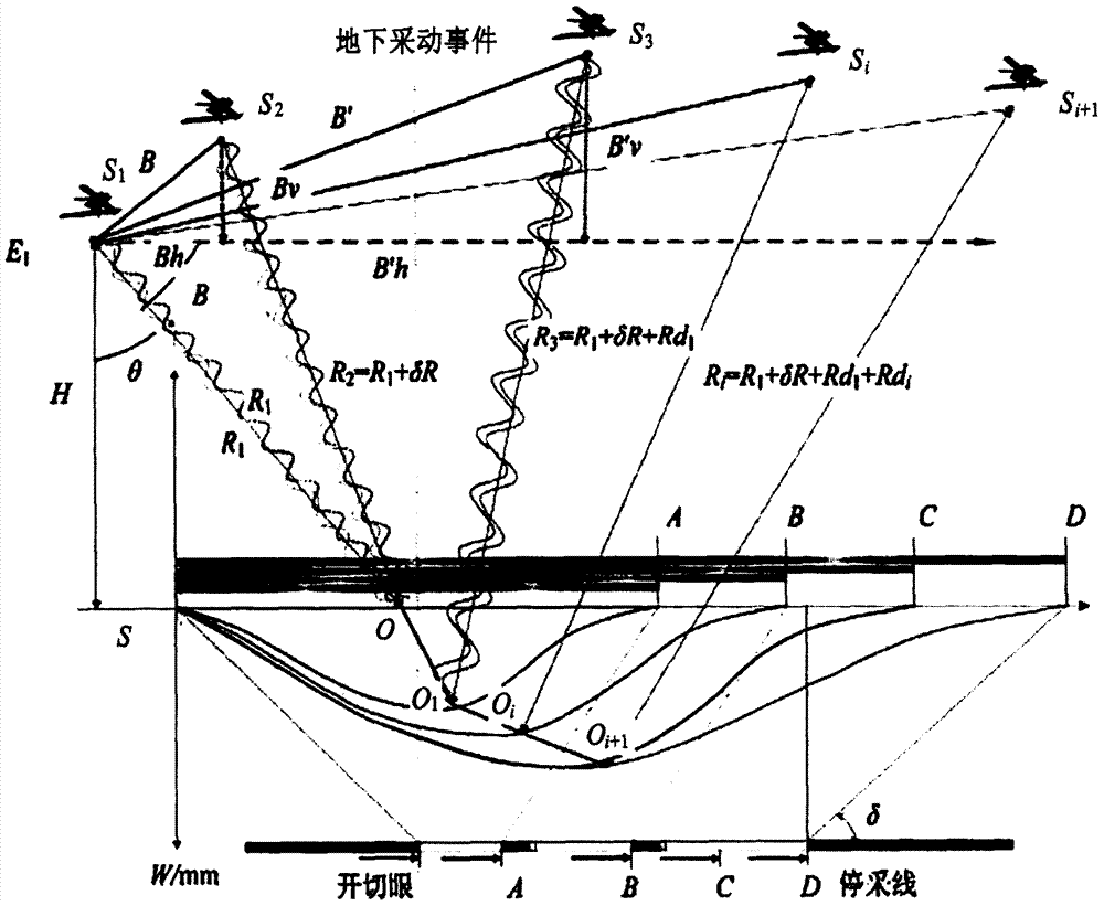
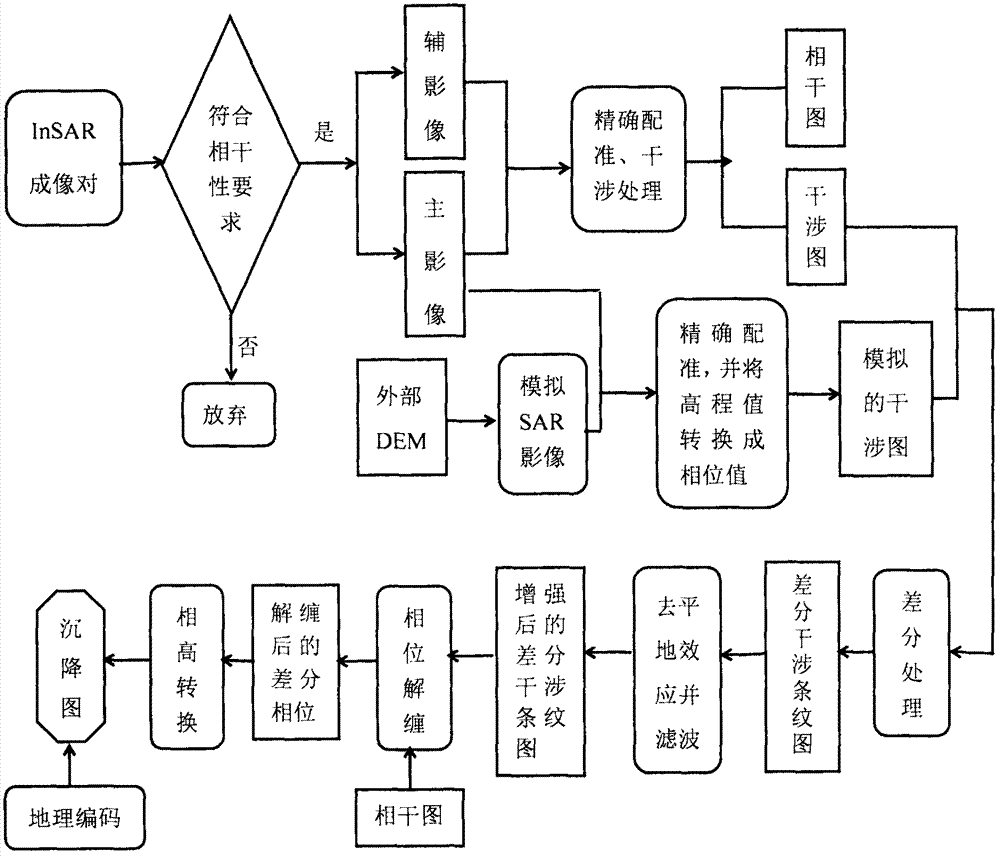
[0072] The data acquisition module is used to acquire land subsidence information in the mining area through dual-track D-InSAR technology, and accurately conducts key steps and methods such as image pair registration, filtering, phase unwrapping, baseline parameter calculation, and multi-view processing coefficient selection. to obtain more accurate land subsidence information in mining areas;

[0073] The spatio-temporal database includes three levels of concept, logic and physics. Conceptually, the information contained in the spatio-temporal database is fully described. Logically, geographic modeling theory is used to establish a spatio-temporal data of mining subsidence that includes spatio-temporal process, geometry, scale, and semantics. Model, which fully describes and expresses the time, space and attribute inf...


PUM


Abstract

The invention discloses an underground illegal mining identification method and system integrated with the D-InSAR and GIS technology. The method includes the steps of integrating the D-InSAR technology and the GIS technology comprehensively, and building a mining subsidence space-time database by taking vectors, digital rasters, radar images and social reports as the data base and an oracle 13g framework as an underlying platform; and realizing the management and processing technology of massive data, the extraction technology of deformation information and the identification of underground illegal mining by calling attribute acquisition, graphics clipping, element conversion, reclassification, raster technology, overlay analysis, map algebra, contour and curvature and slope generation and other spatial data processing and analysis algorithms provided by the ArcGIS Engine10.3. According to the invention, the purpose of real-time dynamic monitoring of underground illegal mining activities is achieved.

Description

technical field [0001] The invention relates to the field of illegal mining identification, in particular to an underground illegal mining identification method and system integrating D-InSAR and GIS technologies. Background technique [0002] At present, coal mining, as one of the important means of economic development in developing countries, has destroyed the ecological environment, disturbed the natural balance of the earth's surface and the lithosphere, caused hidden dangers of natural disasters such as ground subsidence, and triggered a series of serious mining accidents. For a long time, China's coal production ranks first in the world, accounting for more than 90% of the country's total mineral production, of which 95% belongs to underground mining. According to the statistics of the State Administration of Work Safety of China, in 2003 China produced 35% of the world's coal output, but accounted for 80% of the global deaths caused by coal mining, and most of the mi...

Claims


Application Information

Patent Timeline
Patent Type & Authority Applications(China)
IPC IPC(8): G01S13/90
CPCG01S13/9023G01S13/885
Inventor 夏元平汪云甲闫世勇聂运菊李小龙何海清程朋根
Owner EAST CHINA UNIV OF TECH
Learn More