Imaging Test System and Test Method for Geostationary Meteorological Satellite Image Navigation and Registration

A technology of static meteorological satellites and test methods, which is applied in the field of imaging test systems for image navigation and registration of stationary meteorological satellites, can solve problems such as ground test methods that do not involve image frames, and achieve authentic and credible test results

Active Publication Date: 2020-04-21
SHANGHAI SATELLITE ENG INST
View PDF5 Cites 0 Cited by
  • Summary
  • Abstract
  • Description
  • Claims
  • Application Information

AI Technical Summary

Problems solved by technology

[0005] The foreign literature "GOES Users'Conference" introduced the US GOES (Geostationary Orbit Environmental Operations Satellite) satellite in-orbit intra-orbit registration evaluation method and technical level, but did not involve the ground test method of image intra-frame registration

Method used


Image

  • Imaging Test System and Test Method for Geostationary Meteorological Satellite Image Navigation and Registration
  • Imaging Test System and Test Method for Geostationary Meteorological Satellite Image Navigation and Registration
  • Imaging Test System and Test Method for Geostationary Meteorological Satellite Image Navigation and Registration

Examples


Embodiment Construction

[0033] The preferred embodiments of the present invention are given below in conjunction with the accompanying drawings to describe the technical solution of the present invention in detail.

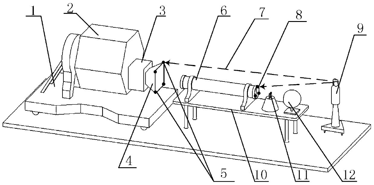
[0034] Such as figure 1 As shown, the imaging test system for navigation and registration of stationary meteorological satellite images of the present invention includes a satellite support 1, a satellite body 2, a load instrument 3, a load instrument hood 4, a load instrument feature point measurement target ball 5, a collimator 6, Laser tracker measuring boresight 7, collimator feature point measuring target sphere 8, laser tracker 9, four-dimensional adjustment mechanism 10, imaging target 11, integrating sphere 12, satellite body 2 is located above satellite bracket 1, satellite body 2, load The instrument shading cover 4 is connected to the loading instrument 3. The loading instrument shading cover 4 is provided with a plurality of loading instrument characteristic point measuremen...


PUM


Abstract

The invention discloses an image navigation and registering imaging test system and method for a static meteorological satellite. The system comprises a satellite support, a satellite body, a load instrument, a load instrument shading cover, a load instrument feature point measurement target ball, a collimator, and a laser tracker measurement shaft. The satellite body is located on the satellite support, and the satellite body and the load instrument shading cove are connected with the load instrument. The system can carry out the quantitative verification of an image navigation and registering scheme at the stage of satellite development.

Description

technical field [0001] The invention relates to a stationary meteorological satellite, in particular to an imaging test system and test method for image navigation and registration of the stationary meteorological satellite. Background technique [0002] In numerical weather forecasting, it is necessary to locate complex regional weather, track the development trend of severe weather, and generate cloud image animations. This requires accurate absolute geographic location of images and accurate registration of relative positional relationships between adjacent images. The accuracy of image navigation registration is related to the processing accuracy of quantitative remote sensing products such as weather diagnosis, cloud image analysis, and disaster monitoring applications. Due to the small size of the detector array of the meteorological geostationary satellite remote sensing instrument, it is impossible to complete the regional imaging through a single frame. It is necess...

Claims


Application Information

Patent Timeline
Patent Type & Authority Patents(China)
IPC IPC(8): G01W1/18
CPCG01W1/18
Inventor 吕旺王田野王皓信思博
Owner SHANGHAI SATELLITE ENG INST
Why Eureka
Try Eureka