Earthquake precursor analysis method based on satellite thermal infrared data and GIS

An analysis method, thermal infrared technology, applied in the direction of seismic signal processing, etc., can solve the problems of single monitoring method and low accuracy rate of earthquake prediction technology, and achieve the effects of low cost, improved accuracy rate, and good research results

Inactive Publication Date: 2017-11-17
四川易利数字城市科技有限公司
View PDF8 Cites 8 Cited by
  • Summary
  • Abstract
  • Description
  • Claims
  • Application Information

AI Technical Summary

Problems solved by technology

[0003] The purpose of the present invention is to solve the problem that the current domestic earthquake prediction technology has a single monitoring method and low accuracy, and proposes an earthquake precursor analysis method based on satellite thermal infrared data and GIS, opening up a new method in the original thermal infrared earthquake prediction. The research direction is to make the time, place and magnitude of earthquake prediction closer to the actual earthquake, thereby improving the accuracy of earthquake prediction

Method used


Image

  • Earthquake precursor analysis method based on satellite thermal infrared data and GIS
  • Earthquake precursor analysis method based on satellite thermal infrared data and GIS
  • Earthquake precursor analysis method based on satellite thermal infrared data and GIS

Examples


Embodiment Construction

[0016] Exemplary embodiments of the present invention will now be described in detail with reference to the accompanying drawings. It should be understood that the implementations shown and described in the drawings are only exemplary, intended to explain the principle and spirit of the present invention, rather than limit the scope of the present invention.

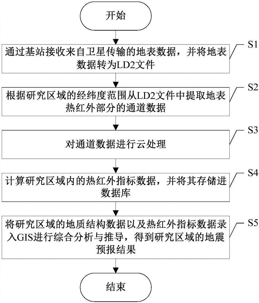
[0017] The invention provides a method for analyzing earthquake precursors based on satellite thermal infrared data and GIS, such as figure 1 As shown, including the following steps S1-S5:

[0018] S1. The base station receives the surface data transmitted from the satellite, and the third-party software converts the surface data into LD2 files.

[0019] S2. Extract the channel data of the surface thermal infrared part from the LD2 file according to the latitude and longitude range of the research area.

[0020] In the embodiment of the present invention, the channel data extraction method is specifically:

[0021] St...


PUM


Abstract

The invention discloses an earthquake precursor analysis method based on satellite thermal infrared data and a GIS. An earthquake prediction analysis is carried out by means of thermal infrared data +GIS, so that the accuracy is improved; the data for the analysis has the large source, so that the research effect is good. Besides, the research direction of the earthquake precursor is extended; and with the GIS way, all quantitative factor that may cause any influence on the earthquake occurrence are accommodated into spatial operation, so that the restriction of analysis of the geological factors and geological formation is eliminated.

Description

technical field [0001] The invention belongs to the technical field of earthquake prediction, and in particular relates to the design of an earthquake precursor analysis method based on satellite thermal infrared data and GIS. Background technique [0002] Southwest China is an area with a high frequency of earthquakes, which generally have the characteristics of high magnitude and strong hazards. Each major earthquake causes huge loss of life and property, and destroys social harmony and stability. So there is an urgent need for new breakthroughs in earthquake disaster prevention. However, earthquake prediction is a difficult problem in the world, mainly because the time, magnitude and location of the forecast are difficult to approach the real earthquake situation. At present, domestic earthquake precursor data analysis methods are various, and the technology is also complicated. Various earthquake precursor analysis methods emerge in endlessly, but there are problems of ...

Claims


Application Information

Patent Timeline
Patent Type & Authority Applications(China)
IPC IPC(8): G01V1/30
CPCG01V1/30
Inventor 杨斌
Owner 四川易利数字城市科技有限公司
Why Eureka
Try Eureka