A Key Interface Design Method for Mobile 3D Virtual Earth System

A technology of 3D virtual and interface design, applied in the field of mobile 3D virtual earth system, can solve problems such as unreasonable design of information retrieval and analysis mechanisms, differences in interaction methods, failure to meet the requirements of mobile GIS system characteristic service functions, etc., to achieve information The search and analysis mechanism is reasonable, the pressure on terminal hardware resources is small, and the effect of meeting the functional requirements of characteristic services

Active Publication Date: 2020-10-16
常州奥视科技有限公司
View PDF5 Cites 0 Cited by
  • Summary
  • Abstract
  • Description
  • Claims
  • Application Information

AI Technical Summary

Problems solved by technology

The current situation of limited hardware resources of mobile terminals inevitably makes the traditional "Digital Earth" software platform framework unable to respond to the needs of data loading in real time
In addition, the difference in interaction methods and the unreasonable design of the core interface of the system, especially the unreasonable design of key interfaces such as the data acquisition interface, virtual camera interface, information query interface, and navigation service interface combined with the hardware characteristics of the mobile terminal, also make the existing The "Digital Earth" software platform cannot run efficiently on mobile terminals
[0004] On the whole, the key interface design method of the mobile 3D virtual earth system in the prior art mainly has the following defects: First, the data acquisition interface is not convenient for data integration, and the mobile 3D virtual earth cannot be acquired in real time through the network within the range of the viewport. Geographic data, the geographic data server cannot quickly respond to terminal requests, and the mobile 3D virtual earth system requests and transmits too many geographic data packets at a time, which cannot adapt to the actual situation of relatively small wireless network bandwidth; second, the interface design of the virtual camera is unreasonable, Users cannot operate and call the virtual camera interface, cannot accurately control the position and attitude of the 3D virtual earth model, and perform operations such as translation, rotation, and zoom on the 3D virtual earth, and cannot realize geographic information browsing at different angles and scales; the third is information query The interface design is complex, the client cannot realize the query function of geographic element information, the information retrieval and analysis mechanism is unreasonably designed, the pressure on the terminal hardware resources is high, and the hardware resources of the client are wasted; the fourth is that the real-time positioning design is backward and cannot meet the requirements of mobile The characteristic service function requirements of the GIS system cannot provide real-time road condition navigation, and users cannot accurately determine the specific position of the current geographic location in the mobile 3D virtual globe through the real-time positioning function, and the extended services such as route navigation combined with driving route query are ineffective.

Method used


Image

  • A Key Interface Design Method for Mobile 3D Virtual Earth System
  • A Key Interface Design Method for Mobile 3D Virtual Earth System
  • A Key Interface Design Method for Mobile 3D Virtual Earth System

Examples


Embodiment Construction

[0042] The technical scheme of a key interface design method of a mobile three-dimensional virtual earth system provided by the present invention will be further described below in conjunction with the accompanying drawings, so that those skilled in the art can better understand the present invention and implement it.

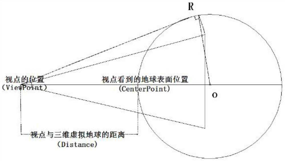
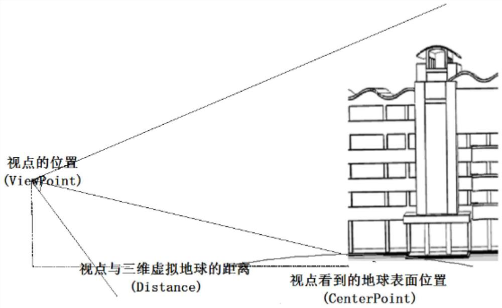
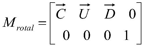
[0043] see figure 1 with figure 2 , a key interface design method of a mobile three-dimensional virtual earth system provided by the present invention, including a data acquisition interface, a virtual camera interface, an information query interface, and a positioning service interface design in combination with the hardware characteristics of a mobile terminal, and the data acquisition is performed using a WMTS network service interface Data integration, user operation calls virtual camera interface to realize real-time data loading and scene switching, information query uses WFS information query interface, and positioning service adopts real-time positioni...


PUM


Abstract

The invention provides a key interface design method of a mobile three-dimensional virtual earth system. The design of a data acquisition interface facilitates data integration, and geographical data packages requested and transmitted by the mobile three-dimensional virtual earth system for single time is relatively few and can be adapted to the actual situation that the bandwidth of the wireless network is relatively small. According to the design of a virtual camera interface, virtual camera parameters are changed, so that the three-dimensional virtual earth visual angle is changed, a user operates and calls the virtual camera interface and accurately controls the position and gesture of a three-dimensional virtual earth model, the operation such as translation, rotation and scaling is conducted on a three-dimensional virtual earth, and geographical information browsing of different angles and different scales is achieved. The pressure of hardware resources of a WFS information query interface design terminal is small, and the cost of the hardware resources of a client is saved. Multiple modes for real-time positioning are adopted, according to the actual situation, a proper positioning method is selected, and the feature service function requirement of a GIS system is met.

Description

technical field [0001] The invention relates to a method for designing an interface of a three-dimensional virtual earth, in particular to a method for designing a key interface of a mobile three-dimensional virtual earth system, and belongs to the technical field of a mobile three-dimensional virtual earth system. Background technique [0002] In recent years, the demand for the construction of "Smart Earth" has made the public need geographic information services to be displayed intuitively and clearly in a three-dimensional manner, and to meet various needs in the fields of urban social management, industrial development, and citizen services. Respond intelligently. "Digital Earth" is a complex model of multi-resolution, multi-scale and multi-type description of the earth based on massive geographic information, and uses it as a tool to provide three-dimensional comprehensive geographic information services. Mobile 3D Digital Earth, as the foundation of "Smart City" cons...

Claims


Application Information

Patent Timeline
Patent Type & Authority Patents(China)
IPC IPC(8): G06F8/38G06F16/29G06F16/957
CPCG06F8/38G06F16/29G06F16/957
Inventor 扆冰礼
Owner 常州奥视科技有限公司
Why Eureka
Try Eureka