Method for mining surface monitoring in mountainous area based on measurement robot and close-range photogrammetry

A technology for measuring robots and close-range photography, applied in measuring instruments, measuring devices, surveying and navigation, etc., can solve the problems of difficulty in reflecting the law of continuous movement and deformation, low precision of close-range photogrammetry technology, and large field workload, etc. The effect of moving deformation omissions, avoiding errors, and improving efficiency

Inactive Publication Date: 2017-12-01
CHONGQING VOCATIONAL INST OF ENG
View PDF6 Cites 6 Cited by
  • Summary
  • Abstract
  • Description
  • Claims
  • Application Information

AI Technical Summary

Problems solved by technology

[0003] At present, research on the influence of coal mining in mountainous areas on ground movement and deformation mainly includes two methods. One is to use traditional methods (total station measurement or GPS measurement) to monitor surface movement and deformation in mountainous areas. The field workload is large and the cost is large. High, and the obtained monitoring data is the moving deformation information of discrete points, which

Method used


Image

  • Method for mining surface monitoring in mountainous area based on measurement robot and close-range photogrammetry
  • Method for mining surface monitoring in mountainous area based on measurement robot and close-range photogrammetry
  • Method for mining surface monitoring in mountainous area based on measurement robot and close-range photogrammetry

Examples


Embodiment Construction

[0033] The present invention will be further described in detail through specific embodiments below.

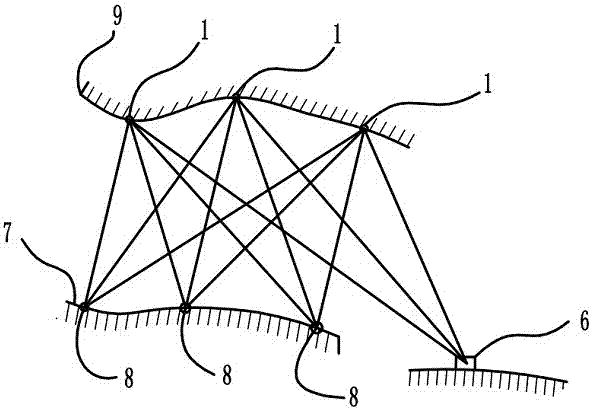
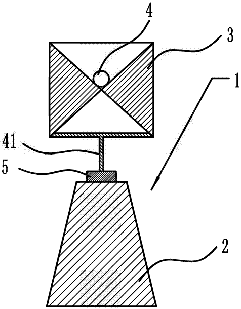
[0034] The reference signs in the drawings of the description include: monitoring station 1, observation pier 2, target 3, SMR prism 4, base 5, reference station 6, stable area 7, photographing station 8, deformation area 9, leveling cylinder 21 , Telescopic cylinder 22, wiping rod 23, angle sensor 24, hair brush 25, controller 26, support rod 41.

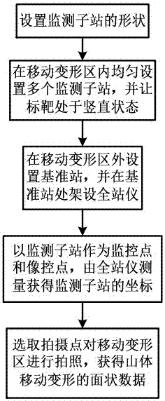
[0035] Such as image 3 The structure of the monitoring station 1 shown, and as figure 1 and figure 2 The surface monitoring method of mountainous mining based on measuring robot and close-range photogrammetry is shown, including the following contents:

[0036] S1, first select a plurality of monitoring stations 1, and bury 80% of the monitoring stations 1 evenly in the moving deformation area 9, and all the monitoring stations 1 in the moving deformation area 9 are not located on the same straight line or on the same plane, ...


PUM


Abstract

The invention relates to the technical field of surface movement and deformation monitoring in a mining section, in particular to a method for mining surface monitoring in a mountainous area based on a measurement robot and close-range photogrammetry. The method comprises: S1, a plurality of monitoring stations are arranged uniformly in a moving deformation area, observation pillars of the monitoring stations are buried into soil, and whether targets are in a vertical state is determined by a level meter; S2, the monitoring stations are set to be the observation pillars and the targets; S3, a base station is arranged beyond the moving deformation area and a total station is erected at the base station; S4, the monitoring stations are used as photo control points and monitoring points and the total station carries out measurement to obtain coordinates of the monitoring stations; and S5, a shooting point is selected to shoot the moving deformation area to obtain facet data of moving deformation of a mountain. Therefore, the total station obtains the high-precision mining surface movement deformation discrete data of the mountainous area and close-range photogrammetry is carried out to obtain high-precision moving deformation facet data of the mountain; and the surface movement deformation situation of the mountain can be observed continuously.

Description

technical field [0001] The invention relates to the technical field of surface environment monitoring in mining areas, in particular to a monitoring method for mining surface in mountainous areas based on measuring robots and close-range photogrammetry. Background technique [0002] With the development of modern industry, coal resources are becoming more and more important, which accelerates the mining of coal resources. The origin of coal is mainly located in the mountainous areas of the central and western regions, and coal is distributed deep underground as a special geological layer. When underground coal is mined, the surface may sink and deform, and in severe cases, it will collapse and cause Surface buildings and fields are damaged, so it is particularly important to monitor the movement and deformation of coal mining areas in mountainous areas. [0003] At present, research on the influence of coal mining in mountainous areas on ground movement and deformation main...

Claims


Application Information

Patent Timeline
IPC IPC(8): G01B11/16G01C1/04G01C5/00G01C15/00
CPCG01B11/16G01C1/04G01C5/00G01C15/00
Inventor 王启春马洪浩李天和冯大福焦亨余邓军
Owner CHONGQING VOCATIONAL INST OF ENG
Why Eureka
Try Eureka