Real-time splicing method for unmanned aerial vehicle aerial stereo images

An image and key frame technology, applied in the field of image processing, can solve the problems of high computational complexity and poor real-time performance of aerial photography, and achieve the effect of avoiding splicing dislocation, ensuring real-time splicing, and avoiding excessive overlap rate

Active Publication Date: 2017-12-22
CHENGDU JOUAV AUTOMATION TECH
View PDF5 Cites 13 Cited by
  • Summary
  • Abstract
  • Description
  • Claims
  • Application Information

AI Technical Summary

Problems solved by technology

[0004] The technical problem to be solved by the present invention is to avoid the excessively high calculation amount caused by the high overlap rate of two adjacent key frames, resulting in the poor real-time performance of aerial photography, and the purpose is to provide a real-time The splicing method adjusts the extraction interval of the subsequent key frame images in real time according to the relationship between the current inter-frame intervals as the attitude of the UAV changes, so as to ensure that the overlapping area and overlap rate of each adjacent two key frames meet the requirements of splicing images , and also avoid the problem of excessive calculation caused by the high overlap rate of two adjacent key frames, and finally realize the real-time stitching of aerial images

Method used


Image

  • Real-time splicing method for unmanned aerial vehicle aerial stereo images

Examples


Embodiment 1

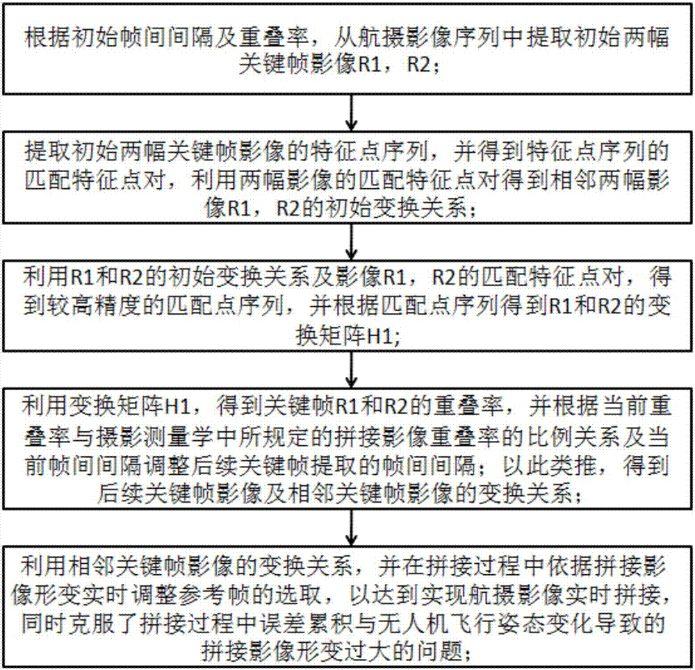
[0033] like figure 1 Shown, the present invention comprises a kind of real-time mosaic method of unmanned aerial vehicle aerial image, comprises the steps:

[0034] Step A) Set the initial reference frame R1 and the inter-frame interval Gap0 extracted from the initial key frame. The inter-frame interval Gap0 is set according to the requirements for the overlapping ratio of aerial photography images; the requirements for the overlapping ratio of aerial photography images have specific regulations. The overlap rate refers to the ratio of the part of the adjacent key frame image overlapping the former key frame image by the subsequent key frame image, which is defined as the prior art.

[0035] Step B) According to the inter-frame interval Gap0 extracted from the initial key frame, the key frame R2 is obtained from the sequence aerial image; in the existing aerial image sequence, the overlapping rate of adjacent aerial images is very high, if the Stitching will lead to computati...

Embodiment 2

[0046] This embodiment is preferably as follows on the basis of the above-mentioned embodiments: step F) calculate the overlap rate between adjacent key frame images according to the transformation relationship of adjacent key frame images, and then according to the current overlap rate and the stipulated in photogrammetry Stitching the proportional relationship of image overlap rate and the current inter-frame interval can realize real-time adjustment of the inter-frame interval of subsequent key frame extraction.

[0047] Step G) continuously dynamically adjust the reference frame during the splicing process, and then use the transformation relations H1, H2, ... Hn-1, n of adjacent key frame images to be positive integers to obtain the reference frame of each key frame image relative to the dynamic selection Then use this transformation relationship to transform each key frame image into the coordinate plane where the dynamically selected reference frame is located, so as to ...

Embodiment 3

[0052] This embodiment is preferably as follows on the basis of the above embodiment: in the above process of obtaining the transformation matrix H1, the feature point sequence S1 and the feature point sequence S2 are a rough matching relationship, that is, there is a mismatched matching feature point pair in the matching feature point pair , resulting in insufficient precision of the transformation matrix H1 obtained by the direct linear transformation algorithm. In order to improve the accuracy of the above transformation matrix H1, according to the existing transformation relationship H1, the error of each matching feature point pair is reversely calculated, that is, after step D) is completed, it is necessary to use the obtained coordinate matching relationship to reversely eliminate the matching error. Matching feature point pairs that meet the requirements, get new feature point sequences S1 and S2 whose errors meet the requirements, and then re-solve the transformation mat...


PUM


Abstract

The invention relates to the field of image processing, in particular to a real-time splicing method for unmanned aerial vehicle aerial stereo images. According to the splicing method for the unmanned aerial vehicle aerial stereo images, an inter-frame interval of key aerial stereo images is adjusted and extracted in real time according to the overlapping ratio of adjacent to-be-spliced aerial stereo images; a transformation matrix of every two adjacent frames is obtained according to a matching relation between homonymy points of every two adjacent frames, and the serial aerial stereo images are transformed to a coordinate system of reference images; and reference frames are adjusted in real time according to set reference frame adjustment judgment conditions, so that accumulative errors generated in the process that the aerial stereo images are transformed to a coordinate system of the reference frames are dispersed to all frames of images, and the situation that serious distortion of subsequent images is caused by error accumulation is avoided.

Description

technical field [0001] The invention relates to the field of image processing, in particular to a method for real-time splicing of unmanned aerial vehicle images. Background technique [0002] In recent years, due to its high efficiency, flexibility, and low cost, UAVs have been widely used in exploration, emergency, disaster relief and other fields. UAV aerial photogrammetry technology greatly reduces the work cycle and manpower and financial investment of traditional aerial photogrammetry technology, making aerial photogrammetry technology more realistic in emergency and disaster relief. On the one hand, the current status of the aerial photography area can be observed through the remote image transmission technology of the equipped video capture equipment; on the other hand, after the aerial photography flight task is completed, the aerial photography image stitching technology can be used to stitch the aerial photography images to obtain the aerial photography Overall i...

Claims


Application Information

Patent Timeline
Patent Type & Authority Applications(China)
IPC IPC(8): G06T3/40G06T7/33G06T7/38
CPCG06T3/4038G06T2200/32G06T2207/10016G06T7/33G06T7/38
Inventor 孙婷婷任斌王陈
Owner CHENGDU JOUAV AUTOMATION TECH
Why Eureka
Try Eureka