
A Precise Common-View Time-Frequency Transfer Method Based on Beidou Geo Navigation Satellite

A technology of time-frequency transfer and navigation satellite, applied in radio-controlled timers, time-division multiplexing systems, instruments, etc., can solve a large number of problems such as solving ambiguity, and achieve the effect of reducing the number of calculations

Active Publication Date: 2018-12-11
NAT TIME SERVICE CENT CHINESE ACAD OF SCI +1
View PDF4 Cites 0 Cited by
  • Summary
  • Abstract
  • Description
  • Claims
  • Application Information

AI Technical Summary

Problems solved by technology

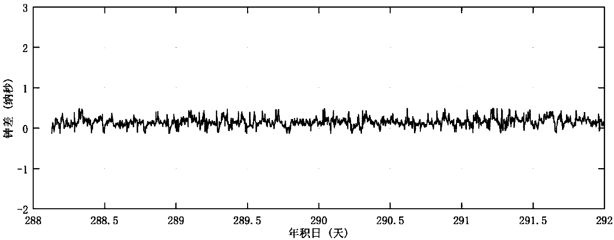
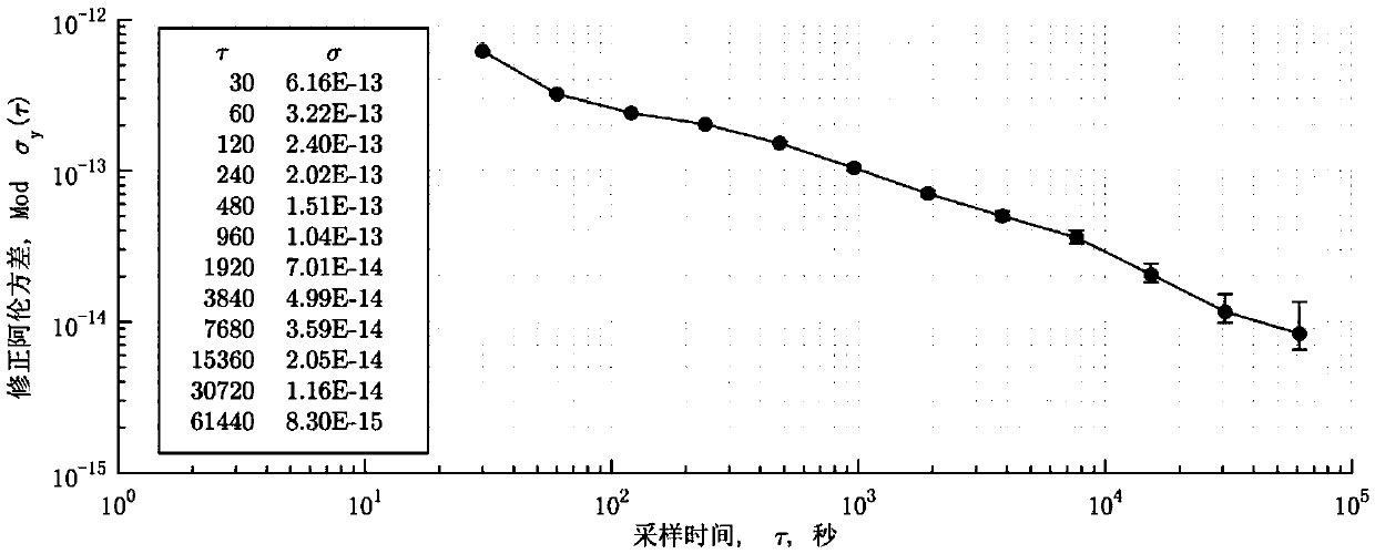
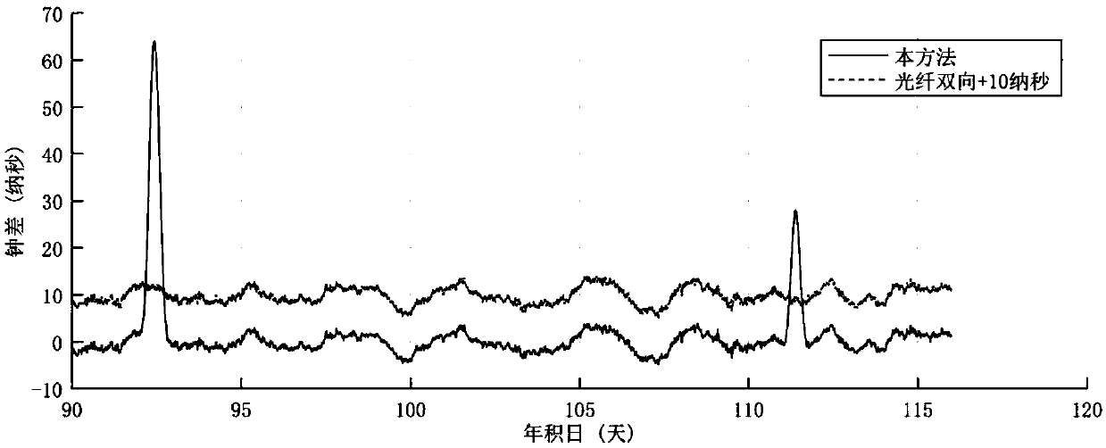
[0007] In order to overcome the existing technologies that can only obtain nanosecond-level precision when using C / A codes for time-frequency transfer, the use of carrier phase data of GPS and other MEO navigation satellites for time transfer needs to consider the error introduced by phase winding, and the use of GPS and other Carrier phase data of MEO navigation satellites needs a large amount of ambiguity to be resolved when carrying out time transfer. The present invention provides a high-precision time-frequency transfer method based on Beidou geostationary orbit (GEO, geostationary) navigation satellites. The high-precision GNSS receiver uses its carrier phase data and the precise orbit products provided by IGS\iGMAS to perform common-view time-frequency transfer. The type A uncertainty of its time transfer can reach sub-nanosecond level. GEO satellites are basically stationary relative to the earth, and can carry out long-term uninterrupted observations, and only need to solve the initial ambiguity once during one observation; the whole arc of the Beidou GEO satellites observed by this method adopts the zero offset control mode, without considering the phase winding effect

Method used


Image

  • A Precise Common-View Time-Frequency Transfer Method Based on Beidou Geo Navigation Satellite
  • A Precise Common-View Time-Frequency Transfer Method Based on Beidou Geo Navigation Satellite
  • A Precise Common-View Time-Frequency Transfer Method Based on Beidou Geo Navigation Satellite

Examples


Embodiment Construction

[0030] The present invention will be further described below in conjunction with the accompanying drawings and embodiments, and the present invention includes but not limited to the following embodiments.

[0031]The present invention uses the carrier phase observation data of the Beidou GEO satellite and uses iGMAS or IGS precision products to realize long-distance inter-station precision common video frequency transmission. The invention is particularly directed to static receivers and high precision time-frequency transfer users. The invention can not only eliminate the influence of satellite clocks, but also eliminate the influence of satellite inter-frequency deviation, use dual-frequency observation data to accurately correct the ionosphere, use troposphere products or models to correct the troposphere, and accurately measure the station coordinates in advance. The advantage of the present invention is that the data of GEO satellites can be used to realize continuous cov...


PUM


Abstract

The invention provides a precise common-view time frequency transmitting method based on a Beidou GEO navigation satellite. The method comprises the following steps: two observation stations participating into the time frequency transmitting connects a to-be-measured atomic clock by using a receiver, and data acquired by the receiver is recorded; the observation data of any Beidou GEO satellite which can be simultaneously observed by the two observation stations is extracted, and the observation data is preprocessed; the satellite-ground distance is computed and the influence by an error source is modified according to a pre-measured observation station coordinate and the acquired ephemeris; the combined ionized layer delay of each of receivers of two stations is resolved according to an observation equation, the combined ionized layer delay is deducted from a combined carrier observation value so as to obtain an initial clock correction result; the inter-epoch differential is performed on the initial clock correction result to acquire a frequency transmitting result of two observation stations, and then the time transmitting effect is acquired. By using the method provided by theinvention, the time synchronization precision is improved, the computation time is reduced, and the phase wrapping influence is avoided.

Description

technical field [0001] The invention relates to a long-distance high-precision time-frequency transmission method. Background technique [0002] At present, BIPM (Bureau International des Poids et Mesures) mainly uses long-distance high-precision time-frequency transfer methods mainly including GNSS (Global Navigation Satellite System, global satellite navigation system) one-way, GNSS CV (Common View time transfer, Common view time transfer), GNSS AV (All in View time transfer, full view time transfer), TW (TWSTFT, Two Way Satellite Time and Frequency Transfer, satellite two-way time and frequency transfer), PPP (Time and frequency transfer using the Precise Point Positioning method , precision single point positioning time-frequency transfer) and other technologies, as well as derived technologies, such as TWPPP, which is a combination of satellite two-way technology and PPP technology. [0003] GNSS one-way, including GLN (GLONASS, Russian Global Navigation Satellite Syst...

Claims


Application Information

Patent Timeline
Patent Type & Authority Patents(China)
IPC IPC(8): H04J3/06G04R20/02
Inventor 韦沛杨旭海钦伟瑾
Owner NAT TIME SERVICE CENT CHINESE ACAD OF SCI
Learn More