Beidou navigation and positioning based unmanned aerial vehicle fish shoal detecting system

A Beidou navigation and unmanned aerial vehicle technology, applied to radio wave measurement systems, satellite radio beacon positioning systems, measurement devices, etc., can solve problems such as waste, inaccurate fish schools, losses, etc., and achieve the goal of avoiding waste and reducing costs Effect

Inactive Publication Date: 2018-03-30
WUXI TONGCHUN NEW ENERGY TECH
View PDF0 Cites 7 Cited by
  • Summary
  • Abstract
  • Description
  • Claims
  • Application Information

AI Technical Summary

Problems solved by technology

[0002] At present, due to the inaccuracy of determining the position of fish schools in offshore waters, it is a waste of time for the offshore fishery command center to send fishing boats to search for fish schools at sea, and even return to the fishing port because they did not find fish schools
[0003] At the same time, the determination of the size of the fish school is not accurate, causing the offshore fishery command center to dispatch too many fishing boats when commanding the fishing of small fish schools; when commanding the fishing of large fish schools, the number of fishing boats dispatched is very insufficient
This all contributes to waste and losses in fisheries production

Method used


Image

  • Beidou navigation and positioning based unmanned aerial vehicle fish shoal detecting system

Examples


Embodiment 1

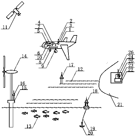
[0023] China's Beidou satellite navigation system consists of three parts: the space segment, the ground segment and the user segment. The Beidou satellite operates high above the fish in the offshore seawater, and the drone powered by lithium cobalt oxide lithium-ion batteries flies around the fish in the low altitude above the fish. There is an offshore wind turbine in the sea to the left of the fish school, and a fixed reference station on the wind power base is installed on the wind turbine base of the offshore wind turbine, and a fixed reference station on the bottom column is installed above the fish school. Set up a mobile reference station on a buoy on the right of the school of fish. The Beidou satellite sends out the Beidou signal. The fixed reference station on the wind power base, the fixed reference station on the submarine column and the mobile reference station on the buoy form a multi-reference station sea-based augmentation system, and each sends a differentia...

Embodiment 2

[0025] China's Beidou satellite navigation system consists of three parts: the space segment, the ground segment and the user segment. Beidou satellites operate at high altitudes above fish schools in offshore seawater, and drones powered by lithium titanate lithium-ion batteries fly around fish schools at low altitude above fish schools. There is an offshore wind turbine in the sea to the left of the fish school, and a fixed reference station on the wind power base is installed on the wind turbine base of the offshore wind turbine, and a fixed reference station on the bottom column is installed above the fish school. Set up a mobile reference station on a buoy on the right of the school of fish. The Beidou satellite sends out the Beidou signal. The fixed reference station on the wind power base, the fixed reference station on the submarine column and the mobile reference station on the buoy form a multi-reference station sea-based augmentation system, and each sends a differe...


PUM


Abstract

The invention belongs to the technical field of Beidou navigation and positioning application and relates to a Beidou navigation and positioning based unmanned aerial vehicle fish shoal detecting system. The Beidou Satellite is in high-altitude operation above an offshore water area, an unmanned aerial vehicle is in low-altitude flight above a fish shoal in seawater, a fixed base station on a windpower base is mounted on the left of the fish shoal, a fixed base station on a seabed vertical column is mounted above the fish shoal, and a movable base station on a float is arranged on the right of the fish shoal. The Beidou Satellite sends out Beidou signals, the fixed base station on the wind power base, the fixed base station on the seabed vertical column and the movable base station on thefloat form a multi-base-station augmentation system to eliminate or weaken satellite navigation and positioning errors by the augmentation technology, differential positioning is the core of the basestation augmentation technology and can be used for improving satellite positioning precision, and a marine fishery command center is enabled to acquire high-precision positioning service as a BeidouSatellite positioning terminal user and command fishing vessels to catch fishes in the target sea area.

Description

technical field [0001] The invention relates to an unmanned aerial vehicle detection fish school system based on Beidou navigation and positioning, and belongs to the technical field of Beidou navigation and positioning applications. Background technique [0002] At present, due to the inaccuracy of determining the location of fish schools in offshore waters, it is a waste of time for the offshore fishery command center to send fishing boats to search for fish schools at sea, and even return to the fishing port because no fish schools have been found. [0003] At the same time, the determination of the size of the fish school is not accurate, causing the offshore fishery command center to dispatch too many fishing boats when commanding the fishing of small fish schools; when commanding the fishing of large fish schools, the number of fishing boats dispatched is very insufficient. All this results in waste and losses in fishery production. [0004] China Beidou needs to incr...

Claims


Application Information

Patent Timeline
Patent Type & Authority Applications(China)
IPC IPC(8): G01S13/86G01S15/96G01S19/41
Inventor 林华
Owner WUXI TONGCHUN NEW ENERGY TECH
Why Eureka
Try Eureka