Method for improving quality of aerotriangulation in oblique photogrammetry of mountain geomorphology

An oblique photogrammetry and three-quality technology, applied in measuring devices, radio wave measurement systems, satellite radio beacon positioning systems, etc., can solve problems such as unfavorable image matching, easy to generate loopholes, unfavorable feature point extraction and image matching, etc. Achieve the effect of reducing repetitive work and work loss, improving work efficiency, and achieving the best quality of results

Active Publication Date: 2018-04-17
INST OF REMOTE SENSING & DIGITAL EARTH CHINESE ACADEMY OF SCI
View PDF9 Cites 11 Cited by
  • Summary
  • Abstract
  • Description
  • Claims
  • Application Information

AI Technical Summary

Problems solved by technology

[0003] 1. If the mountains have large undulations, the remote sensing aircraft needs to take oblique photography on routes with different absolute flight altitudes under the condition of ensuring the same ground resolution. In the case of the same absolute flight altitude, the obtained oblique images have different ground resolutions, and the size of the same ground object on adjacent images is inconsistent, which is not conducive to image matching;
[0004] 2. Mountainous areas are prone to wind with uncertain direction and speed, which will shake the plants on the mountain and cause image blurring, which is not conducive to feature point extraction and image matching; in addition, wind with uncertain direction and speed in the mountain will cause the aircraft to shake and tilt If it becomes larger, it may even cause the aircraft to hit a mountain or overturn, resulting in a larger image inclination and poorer accuracy, which is not conducive to air triangulation;
[0005] 3. Mountainous landforms are prone to shadows. Different time periods and different dates have different light and shadow effects and colors of images, which is not conducive to image matching;
[0006] 4. Mountainous areas are generally covered by large areas of plants. Plants are objects with low texture and simple geometry. Similar plants are similar in images and difficult to distinguish, which is not conducive to feature point extraction and image matching.
[0007] Therefore, for oblique photogrammetry of mountainous landforms, aerial triangulation problems are more likely to occur than flat land and hills. If the quality of aerial triangulation is poor, faults, distortions, stretches, blurs, and uneven colors may appear in the later real-scene 3D modeling and loopholes, resulting in the failure of job tasks

Method used


Image

  • Method for improving quality of aerotriangulation in oblique photogrammetry of mountain geomorphology
  • Method for improving quality of aerotriangulation in oblique photogrammetry of mountain geomorphology
  • Method for improving quality of aerotriangulation in oblique photogrammetry of mountain geomorphology

Examples


Embodiment Construction

[0054] The following examples are used to illustrate the present invention, but are not intended to limit the scope of the present invention.

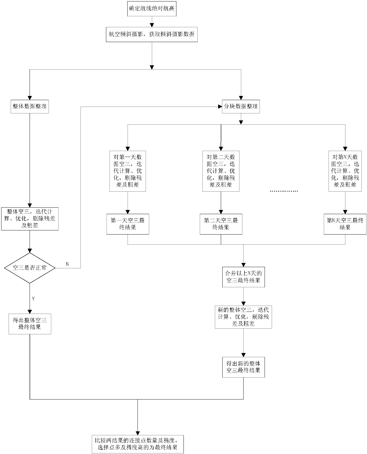
[0055] See attached Figure 1-Figure 4 , a kind of method of the present invention is used for improving the aerial three-dimensional quality of mountain topography oblique photogrammetry, has the following steps:

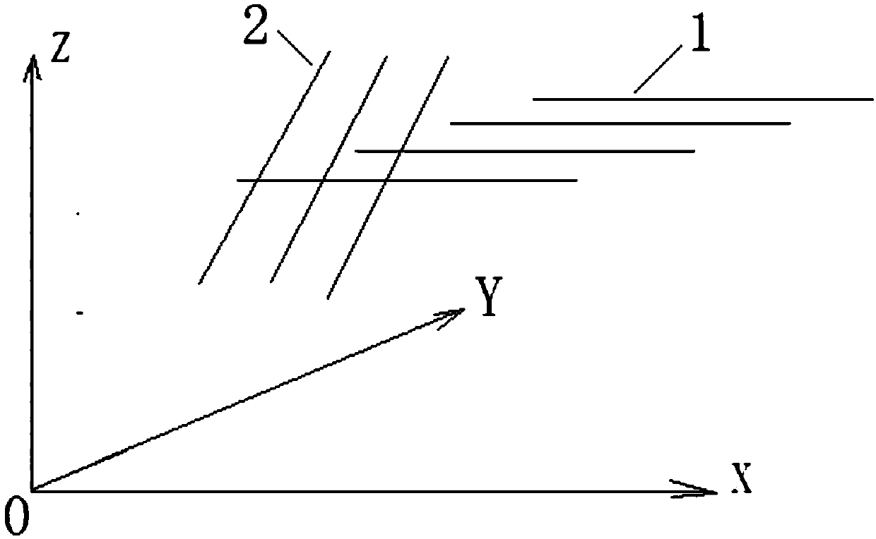
[0056] 1) Determine the absolute flying height of each route according to the ground resolution requirements and the mountain undulations;

[0057] 2) Obtain oblique image data, GNSS data and IMU data of mountainous areas through aerial remote sensing flight;

[0058] 3) Organize oblique image data, GNSS data and IMU data;

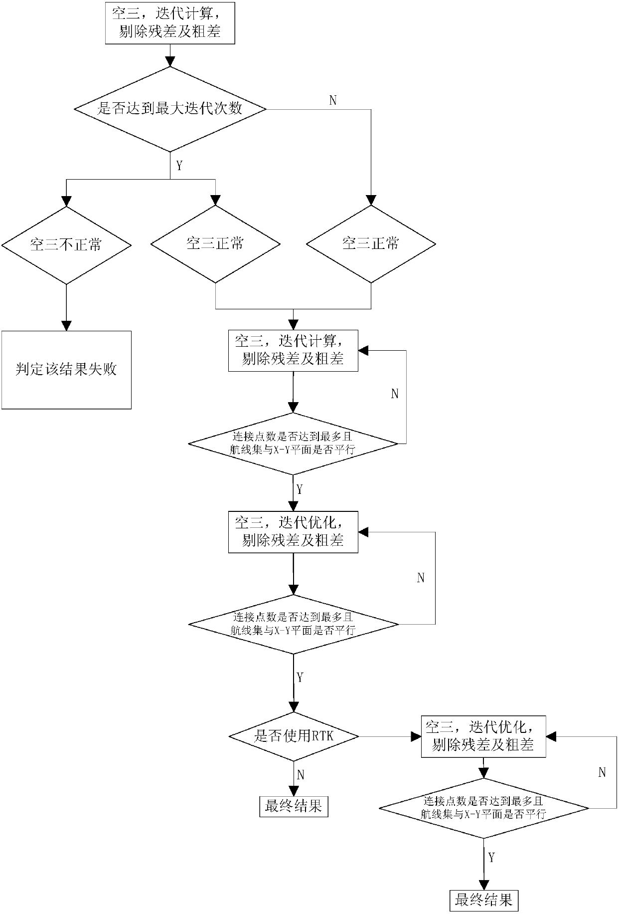
[0059] 4) The overall aerotriangulation and aerotriangulation of blocks first, and then combined aerotriangulation, to obtain the corresponding aerotriage results and aerotriangulation reports;

[0060] 5) Compare the aerial triangulation results and aerial triangulation reports under different condi...


PUM


Abstract

The invention relates to a method for improving quality of aerotriangulation in oblique photogrammetry data of mountain geomorphology. The method comprises the following steps of (1) according to theground resolution requirement and mountain fluctuating condition, determining the absolute flight height of each flight route; (2) obtaining the oblique photogrammetry data, GNSS (global navigation satellite system) data and IMU (inertial measurement unit) data through aviation remote sensing flight; (3) arranging the oblique photogrammetry data, the GNSS data and the IMU data; (4) integrating theaerotriangulation, sectioning the aerotriangulation, and then combining the aerotriangulation, so as to obtain corresponding aerotriangulation results and aerotriangulation reports; (5) comparing theaerotriangulation results and the aerotriangulation reports under different conditions, selecting the optimum result, and applying to mountain real three-dimensional modeling, so as to generate clearand accurate three-dimensional geological information data. The method has the advantages that the oblique photogrammetry data of mountain geomorphology can be quickly post-processed, the quality ofthe aviation measuring data product is quantitatively analyzed, the optimum result is timely judged and selected, the problem of aerotriangulation produced by the mountain geomorphology is solved, theworking efficiency is improved, and the loss is reduced.

Description

technical field [0001] The invention relates to a method for improving the aerial three-dimensional quality of mountainous landform oblique image data, in particular to a method for improving the aerial three-dimensional quality of mountainous landform oblique photogrammetry. Background technique [0002] There are some problems in the aerial triangulation of oblique photogrammetry data of mountainous landforms, including: [0003] 1. If the mountains have large undulations, the remote sensing aircraft needs to take oblique photography on routes with different absolute flight altitudes under the condition of ensuring the same ground resolution. In the case of the same absolute flight altitude, the obtained oblique images have different ground resolutions, and the size of the same ground object on adjacent images is inconsistent, which is not conducive to image matching; [0004] 2. Mountainous areas are prone to wind with uncertain direction and speed, which will shake the ...

Claims


Application Information

Patent Timeline
Patent Type & Authority Applications(China)
IPC IPC(8): G01C11/02G01S19/41
CPCG01C11/02G01S19/41
Inventor 吴亮刘建明李震张云峰
Owner INST OF REMOTE SENSING & DIGITAL EARTH CHINESE ACADEMY OF SCI
Why Eureka
Try Eureka