Cloud base height inversion method based on foundation cloud picture

A ground-based cloud map and cloud base height technology, which is applied to measurement devices, material analysis by optical means, instruments, etc., can solve uncertainties, low spatial and temporal resolution of satellite cloud images, and inability to obtain cloud base heights for low clouds and thick clouds, etc. problems, to expand the scope of application, improve accuracy, and achieve significant effects

Active Publication Date: 2018-04-17
NORTHWEST INST OF ECO-ENVIRONMENT & RESOURCES CAS
View PDF3 Cites 8 Cited by
  • Summary
  • Abstract
  • Description
  • Claims
  • Application Information

AI Technical Summary

Problems solved by technology

[0004] In the prior art, usually, the height of the cloud base is retrieved by using the satellite cloud image. However, since the satellite is taken from the top of the cloud, the cloud base cannot be photographed, and the temporal and spatial resolution of

Method used


Image

  • Cloud base height inversion method based on foundation cloud picture
  • Cloud base height inversion method based on foundation cloud picture
  • Cloud base height inversion method based on foundation cloud picture

Examples


Embodiment Construction

[0036] A method for inversion of cloud base height based on ground-based cloud images, specifically comprising:

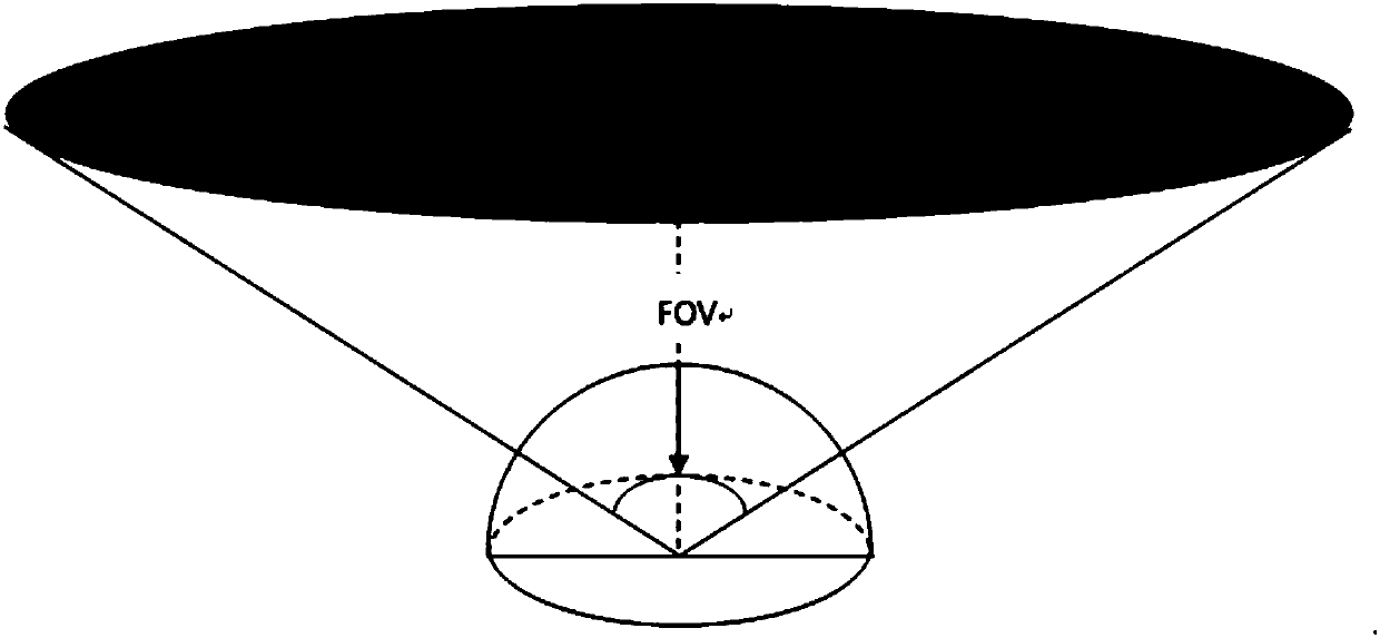
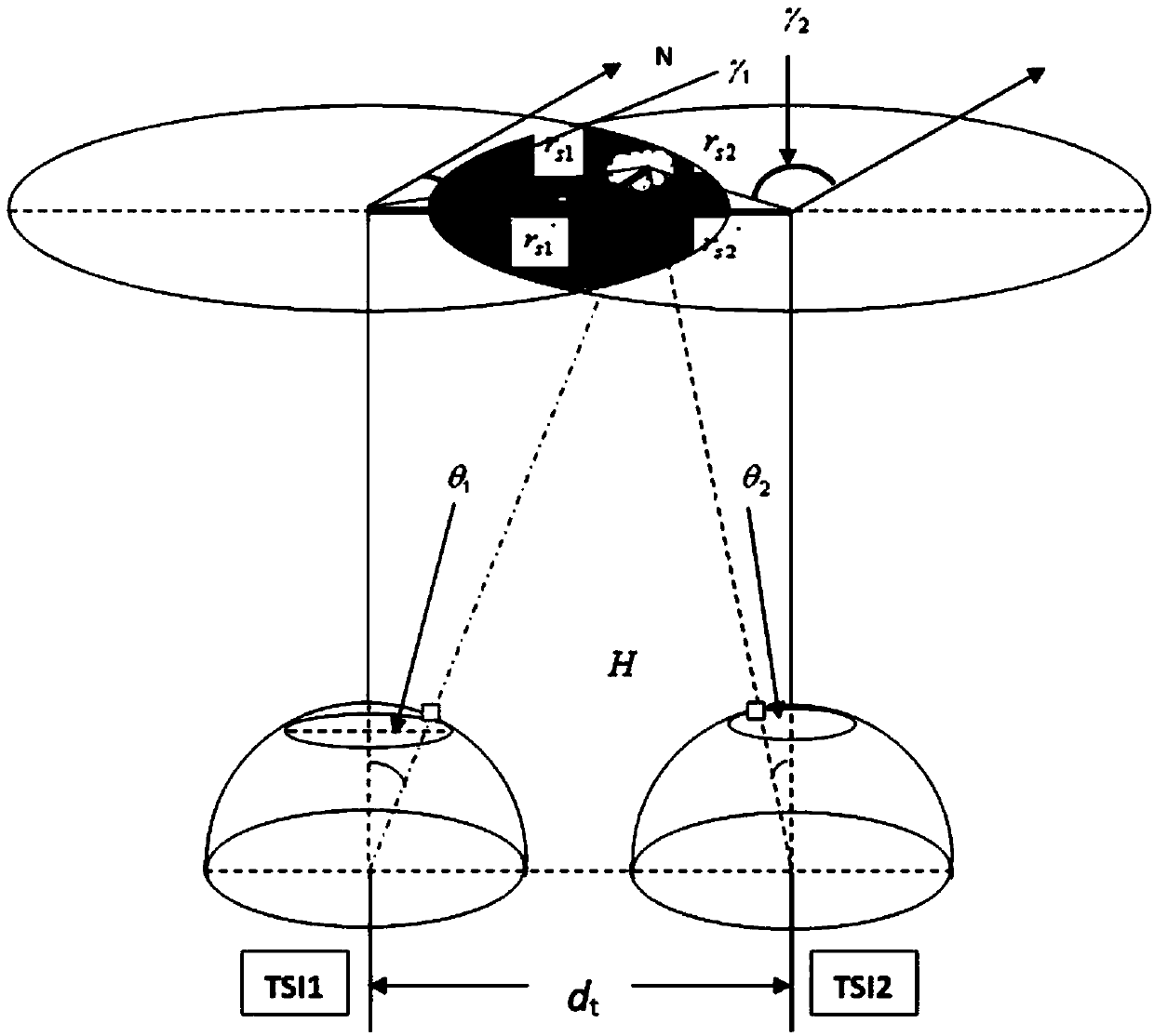
[0037] (1) Select a point to deploy two all-sky imagers, set the field of view of the two to no more than 130°, and make the two observe synchronously and the observed ground-based cloud images have overlapping areas.

[0038] Specifically, two all-sky imagers (TSI for short) deployed in Dunhuang are selected, denoted as TSI1 (longitude 94°31′8″, latitude 40°04′5″, altitude 1200m), TSI2 (longitude 94°28′ 41″, latitude 40°04′42″, altitude 1221m), the distance between the two TSIs is about 3.65km to ensure that the images acquired by the two TSIs overlap.

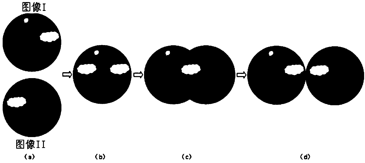
[0039] Since the All-Sky Imager is a spherical mirror image, there is serious radial distortion at its edge. When the zenith angle is greater than 65°, even if it is the same cloud cluster, the imaging shapes of the two instruments are different because of the different viewing angles. Therefore, in order to remo...


PUM


Abstract

The invention relates to a cloud base height inversion method based on a foundation cloud picture. The cloud base height inversion method comprises the following steps: (1) selecting places, deployingtwo whole-sky imaging instruments, setting a field angle of the two whole-sky imaging instruments to be not greater than 130 degrees, enabling the two whole-sky imaging instruments to perform synchronous observation, and enabling the observed foundation cloud picture to have an overlapped area; (2) acquiring the foundation cloud picture synchronously observed by the two all-sky imaging instruments, performing the image matching for the two foundation cloud pictures, and selecting the overlapped area with the smallest difference; and (3) for a cloud cluster selected in the overlapped area in amatching manner, and a cloud base height is inversed by utilizing a geometric relation to obtain an inversion result. Compared with the satellite cloud picture observed from the cloud top in the existing inversion method, the foundation cloud picture is observed on the ground by the whole-sky imaging instruments, i.e., the foundation cloud picture is observed from the cloud base, so that the accuracy of the cloud base height inversion result is improved, and the effect is more significant for the thick cloud and the low cloud. In addition, the application range of the whole-sky imaging instrument is also expanded.

Description

technical field [0001] The invention relates to the technical field of cloud base height inversion, in particular to a cloud base height inversion method based on ground-based cloud images. Background technique [0002] Clouds at different heights have different radiative forcing effects: low clouds have a strong reflection of sunlight, but have a weak effect on the long-wave radiation emitted by the earth-atmosphere system, so they generally have a cooling effect on the earth-atmosphere system; high clouds have a strong effect on sunlight The reflection of the earth-atmosphere system is weak, and the long-wave radiation emitted by the earth-atmosphere system will be significantly reduced, so it generally has a greenhouse effect on the earth-atmosphere system. At the same time, the height of cloud base is of great significance to numerical weather prediction models and precipitation estimation. The height of cloud base determines the long-wave radiation properties of clouds ...

Claims


Application Information

Patent Timeline
IPC IPC(8): G01N21/17
CPCG01N21/17G01N2021/1793
Inventor 蒋俊霞高晓清吕清泉汪宁渤李振朝杨丽薇王定美陈钊张艳丽
Owner NORTHWEST INST OF ECO-ENVIRONMENT & RESOURCES CAS
Why Eureka
Try Eureka