Internet-based remote sensing interpretation and field investigation system and method for unmanned aerial vehicle

A survey system and unmanned aerial vehicle technology, applied in the field of unmanned aerial vehicle remote sensing, can solve the problems of low review efficiency, low review efficiency, and difficulty, and achieve the effect of real-time image transmission

Active Publication Date: 2018-05-04
HUAZHONG NORMAL UNIV
View PDF5 Cites 17 Cited by
  • Summary
  • Abstract
  • Description
  • Claims
  • Application Information

AI Technical Summary

Problems solved by technology

[0004] (1) The existing method is inconvenient for north positioning: in the prior art for the collection of remote sensing interpretation signs, it is necessary to carry a notebook for on-site sketching to establish interpretation signs, and it needs to point north and GPS fixed point, which is extremely difficult to draw. inconvenient;
[0005] (2) The review efficiency of the existing method is low: in the review stage, only the fixed-point review can be done by getting off the vehicle, and it is impossible to review and check the interpretation results of the ground features on both sides during the driving process of the vehicle, which greatly reduces the review efficiency;
[0006] (3) The existing method is inconvenient for field operations in high-risk areas: for areas with inconvenient transportation and complex and dangerous terrain deep in mountainous areas, the field of vision is limited, and only the land types on both sides of the road can be reviewed and interpretation signs can be established;
[0007] (4) The existing method is difficult to obtain the assessment of soil erosion intensity: the photos collected by the handheld device are from a forward-looking perspective, and the interpretation and identification of indoor interpreters are limited. Moreover, it is difficult to obtain the slope and aspect of the place at the same time when establishing field signs. 3D information for soil erosion intensity assessment of the site

Method used


Image

  • Internet-based remote sensing interpretation and field investigation system and method for unmanned aerial vehicle

Examples


Embodiment Construction

[0020] In order to facilitate those of ordinary skill in the art to understand and implement the present invention, the present invention will be described in further detail below in conjunction with the accompanying drawings and embodiments. It should be understood that the implementation examples described here are only used to illustrate and explain the present invention, and are not intended to limit this invention.

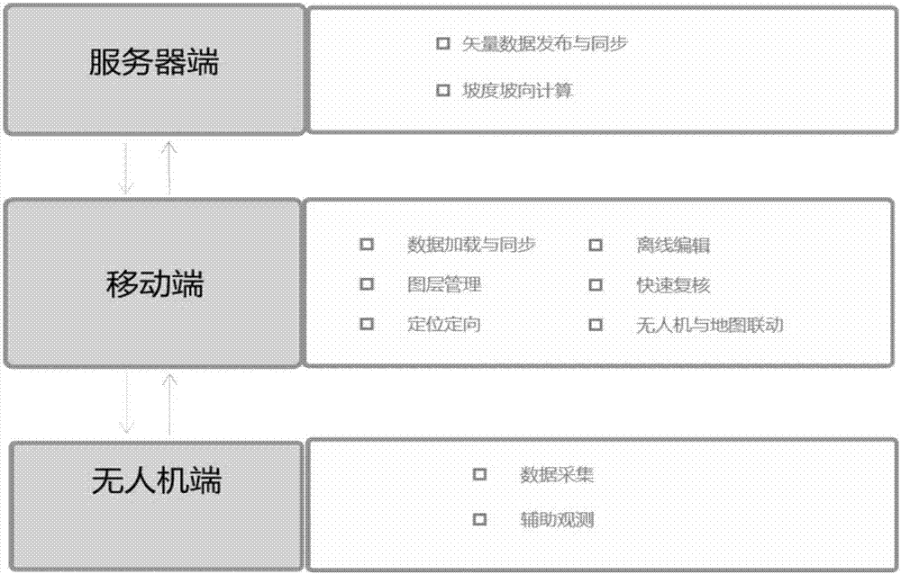
[0021] please see figure 1 , an Internet-based UAV remote sensing interpretation field investigation system provided by the present invention, including a UAV, a mobile intelligent terminal, and a server;

[0022] UAVs include UAV platforms and gimbals. The pan / tilt is installed on the UAV platform and is used for load remote sensing equipment; the remote sensing equipment includes a data acquisition unit and an auxiliary observation unit; the data acquisition unit is used for field data acquisition; Complete the field review and take real photos at the sam...


PUM


Abstract

The invention discloses an internet-based remote sensing interpretation and field investigation system and method for an unmanned aerial vehicle. The system comprises an unmanned aerial vehicle, a mobile intelligent terminal and a server, wherein the unmanned aerial vehicle is used for field data acquisition; the mobile intelligent terminal is used for loading, synchronizing, processing, editing and managing data in a working area and is linked with the unmanned aerial vehicle for performing remote sensing interpretation sign acquisition and rapid data recheck; and the server is used for preparing and managing the data in the working area to realize release and update of the data in the working area, so that collaboration among the server, the unmanned aerial vehicle and the mobile intelligent terminal and data transmission can be completed, and slope and orientation of investigation results are calculated. According to the system disclosed by the invention, collaboration among the server, the unmanned aerial vehicle and the mobile intelligent terminal and data transmission are realized, intelligent, automatic and special subject-based remote sensing interpretation sign acquisitionis realized, offline management and editing of the data can be realized, and sampling inspection of the remote sensing interpretation results is completed. The system disclosed by the invention is lightweight, automatic, high in efficiency, real-time in image transmission and flexible.

Description

technical field [0001] The invention belongs to the technical field of unmanned aerial vehicle remote sensing, and in particular relates to an Internet-based remote sensing interpretation field investigation system and method for unmanned aerial vehicles. Background technique [0002] Remote sensing interpretation sample data collection is an important part of field investigation, including ground truth photos with detailed information such as geographic coordinates and shooting parameters, and remote sensing image instances corresponding to the ground truth photos. Completing the sample collection of remote sensing interpretation, and at the same time reviewing the results of remote sensing interpretation by means of sampling surveys in the field, can assist indoor interpreters to more efficiently recognize the information contained in remote sensing images, and provide detailed on-the-spot information for remote sensing image interpretation. Reference information provides ...

Claims


Application Information

Patent Timeline
Patent Type & Authority Applications(China)
IPC IPC(8): G01C11/00H04B7/185H04L29/08
CPCG01C11/00H04B7/18506H04L67/12
Inventor 李畅魏东赵偲斯张鹏飞吴宜进杨萌
Owner HUAZHONG NORMAL UNIV
Why Eureka
Try Eureka