SLR station three-dimensional coordinate geometric solution method based on low-orbit satellite satellite-borne GNSS technology

A technology of low-orbit satellites and three-dimensional coordinates, which is applied in satellite radio beacon positioning systems, electromagnetic wave reradiation, and measurement devices, etc., to achieve the effect of simple methods, avoiding dynamic models, and convenient centering measurement

Active Publication Date: 2018-05-22
SHANDONG UNIV OF SCI & TECH
View PDF3 Cites 14 Cited by
  • Summary
  • Abstract
  • Description
  • Claims
  • Application Information

AI Technical Summary

Problems solved by technology

[0005] The object of the present invention is to propose a kind of SLR station three-dimensional coordinate geometry solution method based on low...

Method used


Image

  • SLR station three-dimensional coordinate geometric solution method based on low-orbit satellite satellite-borne GNSS technology
  • SLR station three-dimensional coordinate geometric solution method based on low-orbit satellite satellite-borne GNSS technology
  • SLR station three-dimensional coordinate geometric solution method based on low-orbit satellite satellite-borne GNSS technology

Examples


Embodiment Construction

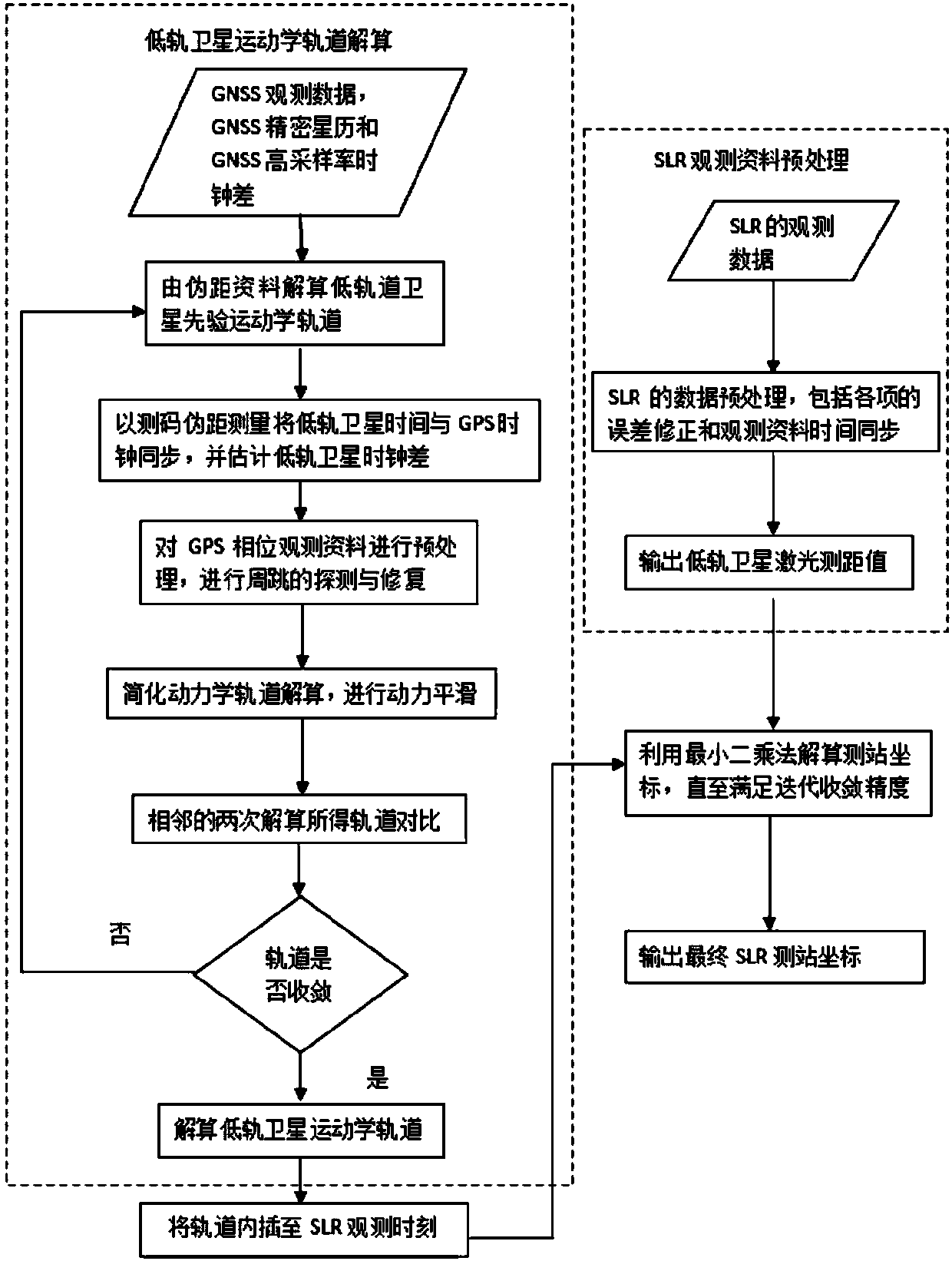
[0044] Below in conjunction with accompanying drawing and specific embodiment the present invention is described in further detail:

[0045] to combine figure 1 As shown, the embodiment of the present invention provides a kind of SLR station three-dimensional coordinate geometry solution method based on low-orbit satellite GNSS technology, which includes the following steps:

[0046]s1. Use low-orbit satellite GNSS technology to perform precise kinematic orbit determination on low-orbit satellites.

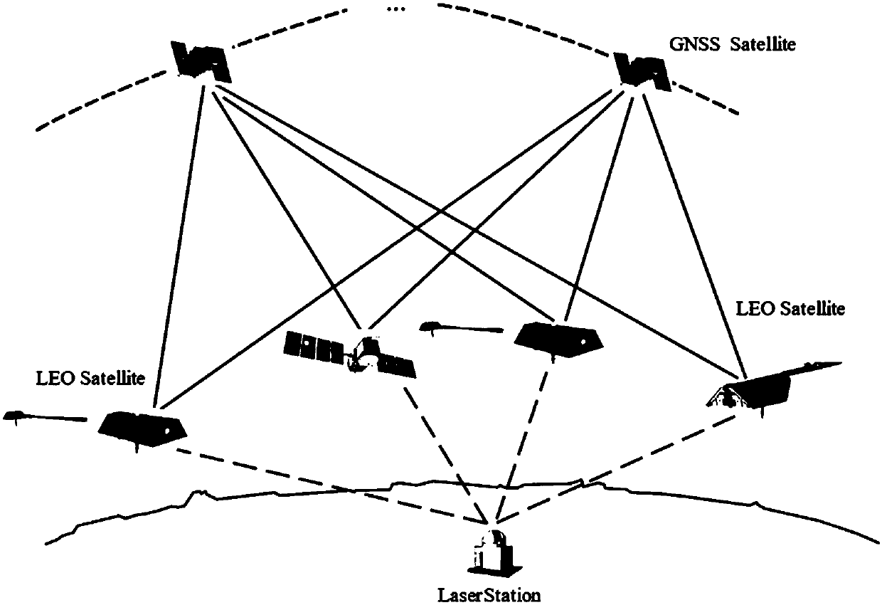
[0047] Such as figure 2 As shown in , the GNSS receiver carried on the low-orbit satellite is used for tracking observation, and the kinematic precision orbit determination is carried out by the non-difference method under the condition of more than three GNSS satellites (such as GPS satellites, etc.). exist figure 2 Among them, GNSS Satellite represents GNSS satellites, LEO Satellite represents low-orbit satellites, and Laser Station represents SLR stations.

[0048] Geomet...


PUM


Abstract

The invention discloses an SLR station three-dimensional coordinate geometric solution method based on low-orbit satellite satellite-borne GNSS technology. According to the geometric solution method,a GNSS receiver mounted on a low-orbit satellite is used to perform continuous tracking observation, and an undifferenced method is used to perform a precise kinematic orbit determination for the low-orbit satellite; then a satellite laser ranging rangle reflection prism carried in the low-orbit satellite is used to obtain an SLR laser ranging value, the system error correction is carried out on an SLR observation material, the material is converted into a distance between a high precision SLR station and a centroid of the low-orbit satellite, and combined with a precise geometric orbit of a multi-epoh single or multiple low-orbit satellites, according to the distance intersection positioning principle, the three-dimensional geometric coordinates of the ground SLR observation station are calculated by a least-squares method. The satellite-borne GNSS data and SLR tracking observation data of low-orbit satellites are used, a geometric method is used to realize high-precision geometric coordinates solution of the ground SLR observation station, and the solution has the advantage that a complex dynamics model is avoided compared with a classical dynamics solution.

Description

technical field [0001] The invention relates to a three-dimensional coordinate geometric solution method of an SLR station based on low-orbit satellite-borne GNSS technology. Background technique [0002] Satellite Laser Ranging (SLR) is a two-way ranging method for tracking and observing satellites by measuring the round-trip propagation time of laser pulses between the ground and the satellite. , such as very long baseline interferometry (VLBI), global navigation satellite system (GNSS), satellite Doppler orbit determination and positioning system (DORIS), etc. The main difference. GNSS is a very important space technology that provides precise positioning, navigation and time services on a global or regional scale. GNSS mainly includes GPS in the United States, GLONASS in Russia, and several other emerging global / regional navigation satellite systems, such as Galileo in Europe and Beidou in China. [0003] At present, the space geodetic technology based on VLBI, SLR, GN...

Claims


Application Information

Patent Timeline
IPC IPC(8): G01S19/14G01S17/48
CPCG01S17/48G01S19/14
Inventor 郭金运王友存刘新孔巧丽沈毅刘路
Owner SHANDONG UNIV OF SCI & TECH
Why Eureka
Try Eureka