Method and device for underwater topographic survey of shallow water

An underwater terrain and measuring device technology, which is used in measuring devices, open-air water source survey, navigation through speed/acceleration measurement, etc. To avoid data anomalies, improve measurement accuracy and measurement efficiency

Pending Publication Date: 2018-06-12
CAPITAL NORMAL UNIVERSITY
View PDF9 Cites 11 Cited by
  • Summary
  • Abstract
  • Description
  • Claims
  • Application Information

AI Technical Summary

Problems solved by technology

[0003] For underwater terrain surveys in shallow water areas, currently more commonly used methods include: manual use of GNSS RTK and probe rods for single-point positioning and sounding. This method has low operating efficiency, high labor costs, and a great threat to personnel safety and equipment safety. ; Or use the acoustic measurement method, but this method is susceptible to interference in shallow water areas. Once the ac...

Method used


Image

  • Method and device for underwater topographic survey of shallow water
  • Method and device for underwater topographic survey of shallow water

Examples


Embodiment Construction

[0027] The following will clearly and completely describe the technical solutions in the embodiments of the present invention with reference to the accompanying drawings in the embodiments of the present invention. Obviously, the described embodiments are only some, not all, embodiments of the present invention. Based on the embodiments of the present invention, all other embodiments obtained by persons of ordinary skill in the art without making creative efforts belong to the protection scope of the present invention.

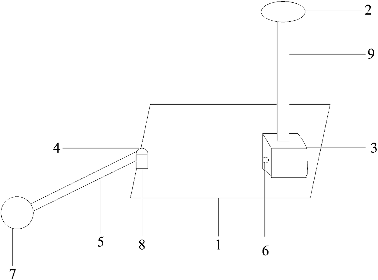
[0028] The object of the present invention is to provide a shallow water area underwater topography measurement device and method, through satellite positioning and inertial navigation technology to collect moving track on the water, directly contact the bottom topography through the mechanical probe rod, to avoid the occurrence of acoustic or optical bottom measurement Compared with traditional operations, it not only improves the measurement accuracy and meas...


PUM


Abstract

The invention provides a method and device for underwater topographic survey of shallow water. The device comprises a GNSS (global navigation satellite system) base station, a movable operating carrier, a worktable, a GNSS mobile station, an IMU (inertial measurement unit), an angle rotary encoder, a divining rod and a data storage chip, and the worktable, the GNSS mobile station, the IMU, the angle rotary encoder, the divining rod and the data storage chip are arranged on the movable operating carrier. A metal ball is fixed to one end, extending underwater, of the divining rod and directly contacts with the underwater terrain. According to the survey method, the mechanical divining rod directly contacts with the underwater terrain, and data abnormality in acoustic or optical underwater survey is avoided; by the GNSS mobile station, the IMU and the angle rotary encoder combined moving trail acquisition techniques, underwater topographic data are dynamically acquired, and accordingly underwater topographic survey precision and efficiency are improved.

Description

technical field [0001] The invention relates to the field of underwater terrain measurement, in particular to an underwater terrain measurement device and method for shallow water areas. Background technique [0002] Underwater topographic survey is an important operation content of engineering surveying and mapping such as marine surveying, waterway surveying and lake surveying and mapping. Underwater topographic survey mainly includes two parts: positioning and sounding. Water positioning means mainly include optical instrument positioning, radio positioning, satellite positioning and combined positioning, etc. Water sounding means mainly rely on echo sounder. [0003] For underwater terrain surveys in shallow water areas, currently more commonly used methods include: manual use of GNSS RTK and probe rods for single-point positioning and sounding. This method has low operating efficiency, high labor costs, and a great threat to personnel safety and equipment safety. ; Or...

Claims


Application Information

Patent Timeline
IPC IPC(8): G01C13/00G01C21/16
CPCG01C13/00G01C21/165Y02A90/30
Inventor 王留召蔡海永钟若飞张富杰
Owner CAPITAL NORMAL UNIVERSITY
Why Eureka
Try Eureka