Positioning and orientation method for portable target indicator

A positioning and indicator technology, which is applied to satellite radio beacon positioning systems, instruments, measuring devices, etc., can solve the problems of long radio frequency cables, large measuring antennas, and restrictions on the application of portable indicators

Inactive Publication Date: 2018-06-26
BEIJING INST OF COMP TECH & APPL
View PDF5 Cites 4 Cited by
  • Summary
  • Abstract
  • Description
  • Claims
  • Application Information

AI Technical Summary

Problems solved by technology

However, the accuracy of the electronic compass to measure the azimuth is not high, which limits the positioning accuracy of the observation target
With the development of the satellite navigation system, the directional technology using dual antennas fo...

Method used


Image

  • Positioning and orientation method for portable target indicator

Examples


Embodiment Construction

[0008] In order to make the purpose, content, and advantages of the present invention clearer, the specific implementation manners of the present invention will be further described in detail below in conjunction with the accompanying drawings and embodiments.

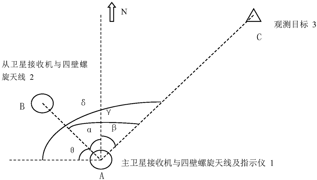
[0009] figure 1 Shown is a layout diagram of a positioning and orientation method used for portable indicators according to the present invention, as figure 1 As shown, a method for target observation by a positioning and orientation method used by a portable indicator of the present invention includes the following steps:

[0010] The first step: equipment layout

[0011] The main satellite receiver is directly connected to the four-wall helical antenna and the target indicator is placed at position A, and the slave satellite receiver is directly connected to the four-wall helical antenna and placed at position B. The distance between A and B is greater than 5m, and A and B are connected to form a line L1; the obser...


PUM


Abstract

The invention provides a positioning and orientation method for a portable indicator. The method includes the following steps: step I device arrangement which includes connecting a main satellite receiver and a four-wall spiral antenna, placing the receiver, the antenna and the target indicator at the position A which serves as the original point, connecting an auxiliary satellite receiver and thefour-wall spiral antenna, placing them at the position B with the distance between A and B more than 5m, wherein a connecting line of A and B forms the line L1; step II satellite receiver positioningwhich includes obtaining the azimuth Alpha between L1 and the north direction after the satellite receiver is started up and positioned; step III construction of indicator optical orientation baseline which includes utilizing an optical sighting device of the indicator to point at an antenna of the satellite receiver, recording the indexing mechanism angle position Theta of the indicator, then pointing the optical sighting device of the indicator to an observation target, recording to the indexing mechanism angle position Delta of the indicator, calculating the included angle between the lineL1 and the line L2, Gamma=Delta-Theta; step IV target position resolving which includes calculating the included angle between the line L2 and the north direction Beta= Gamma- Alpha.

Description

technical field [0001] The invention relates to a positioning and orientation method, in particular to a positioning and orientation method for a portable target indicator. Background technique [0002] The target indicator observes the target object from a long distance, and obtains the relative distance between the target and the indicator through laser ranging, and then combines its own geographical coordinates and the azimuth of the optical axis of the indicator aiming at the observed object to calculate the distance of the observed target. geographic coordinates. The geographic coordinates of the target designator itself can usually be obtained through a satellite positioning system, and the azimuth is obtained through an electronic compass. However, the accuracy of the electronic compass to measure the azimuth is not high, which limits the positioning accuracy of the observation target. With the development of the satellite navigation system, the directional technolo...

Claims


Application Information

Patent Timeline
IPC IPC(8): G01S19/43G01S19/45
CPCG01S19/43G01S19/45
Inventor 安振东魏莹莹满翔隋丽娜
Owner BEIJING INST OF COMP TECH & APPL
Why Eureka
Try Eureka