Differential GNSS (Global Navigation Satellite System) and INS (Inertial Navigation System) adaptive tightly-coupled navigation method based on inertial measurement unit

A technology of inertial measurement and navigation method, which is applied in the field of joint navigation, and can solve the problems of increasing cumulative navigation error, affecting the accuracy of integrated navigation, reducing accuracy and reliability, etc.

Active Publication Date: 2018-06-29
BEIJING SATELLITE INFORMATION ENG RES INST
View PDF8 Cites 28 Cited by
  • Summary
  • Abstract
  • Description
  • Claims
  • Application Information

AI Technical Summary

Problems solved by technology

[0003] At present, the commonly used navigation methods mainly include independent INS navigation, independent GNSS navigation, differential GNSS navigation and combined navigation, but these navigation methods have certain deficiencies.
The cumulative error of long-term navigation of INS navigation alone will increase, and its navigation accuracy needs to be guaranteed by high-cost IMU devices; the accuracy of GNSS navigation alone is low, and its reliability is greatly affected by the surrounding environment; The accuracy and reliability in complex environments such as "urban canyons" will be reduced; while the accuracy of integrated navigation depends to a certain extent on the quality of observations, and the quality of observations will inevitably affect the accuracy of integrated navigation

Method used


Image

  • Differential GNSS (Global Navigation Satellite System) and INS (Inertial Navigation System) adaptive tightly-coupled navigation method based on inertial measurement unit
  • Differential GNSS (Global Navigation Satellite System) and INS (Inertial Navigation System) adaptive tightly-coupled navigation method based on inertial measurement unit
  • Differential GNSS (Global Navigation Satellite System) and INS (Inertial Navigation System) adaptive tightly-coupled navigation method based on inertial measurement unit

Examples


Embodiment Construction

[0119] Below in conjunction with accompanying drawing, the specific embodiment of the present invention is described in further detail.

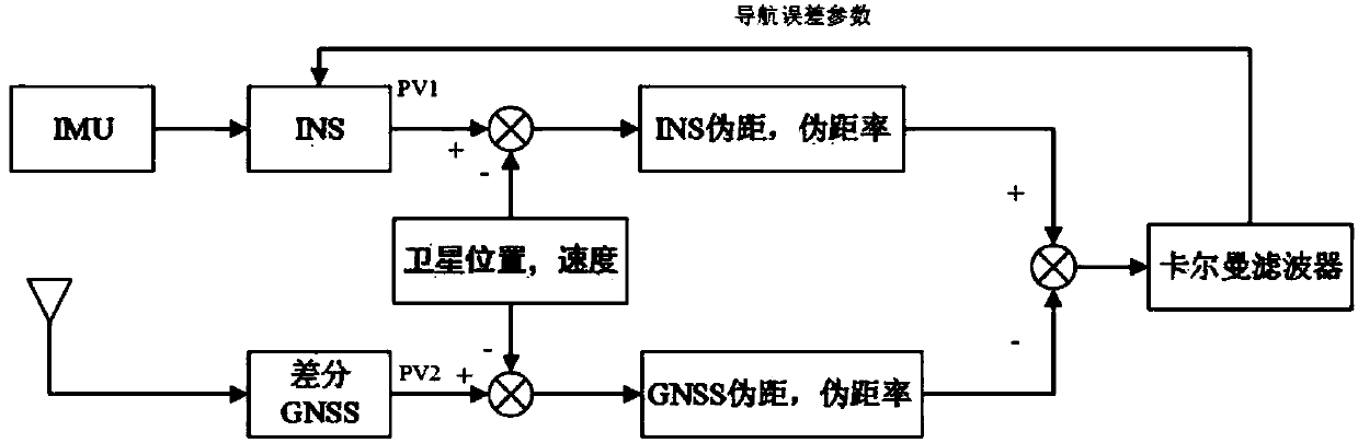
[0120] The present invention proposes a differential GNSS and INS self-adaptive tightly coupled navigation method based on an inertial measurement unit, which overcomes the deficiencies of existing navigation technologies, reduces the cost of system hardware, and ensures the accuracy and reliability of the navigation system in complex environments , the specific features are as follows: the attitude of the system model in the combined filtering state equation adopts Euler angles, and the device error adopts random walk, which is suitable for low-cost IMUs with large device errors and non-zero and unstable characteristics of device error characteristics; integrated navigation filtering The device uses UKF to update the quaternion form, which can describe the variance and expectation of the nonlinear system more accurately, and is also suitable...


PUM


Abstract

The invention relates to a differential GNSS (Global Navigation Satellite System) and INS (Inertial Navigation System) adaptive tightly-coupled navigation method based on an inertial measurement unit.Observation data of a Beidou (BD) navigation system and a GPS (Global Positioning System) navigation system are selected and combined to jointly serve as measurement information for combined filtering; the number of observation satellites is increased and further spatial distribution of the satellites is improved; in addition, data redundancy is improved, and the positioning precision is effectively improved; the number of the satellites which can be observed by the navigation system in complex environments such as urban canyons is added, so that the effectiveness of the navigation system iseffectively improved; by means of a BD / GPS information fusion technology, the dependency on a single system is reduced and the influence of GPS selection failure condition is eliminated.

Description

technical field [0001] The invention relates to a differential GNSS and INS adaptive tightly coupled navigation method based on an inertial measurement unit, belonging to the technical field of joint navigation. Background technique [0002] With the rapid development of navigation technology, the combination of a strapdown inertial navigation system with strong autonomy and a GNSS navigation system with high precision and long-term stability can not only play an important role in the field of high-performance precision guidance, but also serve as a low-cost navigation system. Cost of car navigation system to use. In the fields of life safety such as airship docking, aircraft approach and landing, vehicle autopilot, precision agriculture, and ship entry, high-precision and high-reliability navigation is an important guarantee for them to achieve long-distance missions. [0003] At present, the commonly used navigation methods mainly include independent INS navigation, indep...

Claims


Application Information

Patent Timeline
Patent Type & Authority Applications(China)
IPC IPC(8): G01S19/47G01C21/16
CPCG01C21/165G01S19/47
Inventor 车欢侯利朋刘翔刘骁刘金山李春颖
Owner BEIJING SATELLITE INFORMATION ENG RES INST
Why Eureka
Try Eureka