
A Method for Generating Topology Maps of Wireless Sensor Networks Based on Multi-Extreme Point Selection

A wireless sensor and network topology map technology, which is applied in network topology, wireless communication, data exchange network and other directions, can solve the problems that network characteristics cannot be well represented, the network topology map differs greatly, and the topology map is highly distorted. The effect of calculating the amount, reducing energy consumption, and improving efficiency

Active Publication Date: 2021-06-22
NANJING UNIV OF AERONAUTICS & ASTRONAUTICS
View PDF4 Cites 0 Cited by
  • Summary
  • Abstract
  • Description
  • Claims
  • Application Information

AI Technical Summary

Problems solved by technology

[0005] Although VCS has achieved some research results, it cannot achieve the desired results in some cases.
For example, the ENS method can select reference nodes for VCS, but this method can only select a small number of reference nodes in a network with irregular boundaries. The VCS based on this method cannot well represent the characteristics of the network, and the generated network topology map It is also quite different from the actual coordinate map
In addition, the TPMs method can derive the topological map of the network from the VCS, but its accuracy is not high in large-scale complex networks, and the degree of distortion of the topological map is still high.

Method used


Image

  • A Method for Generating Topology Maps of Wireless Sensor Networks Based on Multi-Extreme Point Selection
  • A Method for Generating Topology Maps of Wireless Sensor Networks Based on Multi-Extreme Point Selection
  • A Method for Generating Topology Maps of Wireless Sensor Networks Based on Multi-Extreme Point Selection

Examples


Embodiment

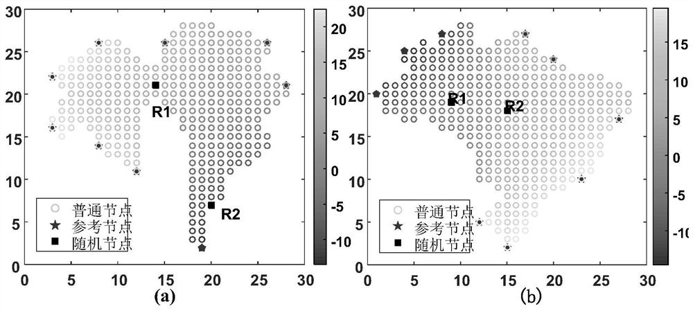
[0050] Two sensor networks with irregular boundaries are deployed in a two-dimensional space of 30m×30m, and the network distribution is as follows: figure 2 Shown; where (a) is a network with 320 nodes, and the network in (b) contains 358 nodes. figure 2 Calculate the value and node selection results for the network DVC. In the figure, R1 and R2 are two randomly selected nodes in the network. The color of the node indicates the size of the DVC value of the node, and the color of the node indicates the size of the DVC value of the node. The lighter the color The larger the DVC value, the darker the color, the smaller the DVC value. The nodes indicated by the asterisks are the reference nodes finally selected by MENS. From figure 2 It can be seen that the extreme points in the network have maximum or minimum values ​​in their neighborhood, and our method can select the extreme points in the network. These extremum points are far apart and are all on the boundary of the ne...


PUM


Abstract

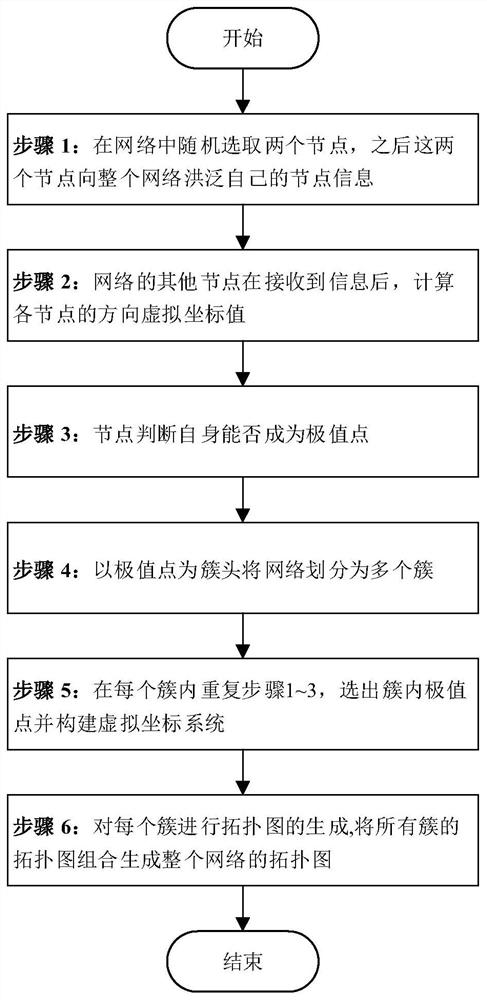
The invention discloses a method MENS-DTPM for generating a wireless sensor network topology map based on multi-extreme point selection, comprising the following steps: step 1, randomly selecting two sensor nodes in the network, and flooding the two nodes to the entire network own node information; step 2, other nodes in the network calculate the virtual coordinate value of each node based on the direction after receiving the information; step 3, each node checks whether its own virtual coordinate value is the extreme value in its neighborhood, If so, the node becomes an extremum point; step 4, divide the network into multiple clusters with the extremum point as the cluster head; step 5, repeat steps 1 to 3 in each cluster, and select the local extremum points in the cluster as Refer to the nodes, and build a virtual coordinate system for each cluster; step 6, generate a topological map for each cluster, and finally combine the topological maps of all clusters to generate a topological map of the entire network. This method can achieve more effective reference node selection, has better results in large-scale complex networks, and can better reflect the structural characteristics of the network.

Description

technical field [0001] The invention relates to a wireless sensor network, in particular to a method for generating a topology map of a wireless sensor network based on multi-extreme point selection. Background technique [0002] Wireless sensor network (WSN) is composed of a large number of energy-constrained sensor nodes, which are mainly used to perceive information in the monitoring area, and the location information of nodes is a key information. In general, WSN uses some location information carrying GPS nodes for node positioning. However, GPS generally works in an open environment without obstacles blocking satellite signals, so in some scenarios, such as indoors and underground, location information cannot be obtained or has very high errors. Therefore, there is a need for a more efficient way to organize and locate WSNs without relying on any location information. Virtual Coordinate Systems (Virtual Coordinate Systems, VCS) is a topology map generation technology...

Claims


Application Information

Patent Timeline
Patent Type & Authority Patents(China)
IPC IPC(8): H04L12/24H04W40/32H04W64/00H04W84/18
CPCH04L41/12H04W40/32H04W64/00H04W84/18
Inventor 顾晶晶苏涛庄毅王秋红
Owner NANJING UNIV OF AERONAUTICS & ASTRONAUTICS
Learn More