Rapid remote-sensing exploration method for landslide glide amount parameter based on big data

A big data and remote sensing technology, applied in the field of remote sensing survey, can solve the problems of inconvenient survey, slow speed and low efficiency

Inactive Publication Date: 2018-08-14
CHONGQING JIAOTONG UNIVERSITY
View PDF5 Cites 1 Cited by
  • Summary
  • Abstract
  • Description
  • Claims
  • Application Information

AI Technical Summary

Problems solved by technology

[0003] To sum up, the problems existing in the existing technology are: the existing remote sensing survey technology is slow and inefficient when dealing with a large amount of data; at the same time, the images obtained directly through remote sensing are not concrete enough to facilitate surveying

Method used


Image

  • Rapid remote-sensing exploration method for landslide glide amount parameter based on big data
  • Rapid remote-sensing exploration method for landslide glide amount parameter based on big data
  • Rapid remote-sensing exploration method for landslide glide amount parameter based on big data

Examples


Embodiment Construction

[0063] In order to make the object, technical solution and advantages of the present invention more clear, the present invention will be further described in detail below in conjunction with the examples. It should be understood that the specific embodiments described here are only used to explain the present invention, not to limit the present invention.

[0064] The application principle of the present invention will be further described below in conjunction with the accompanying drawings and specific embodiments.

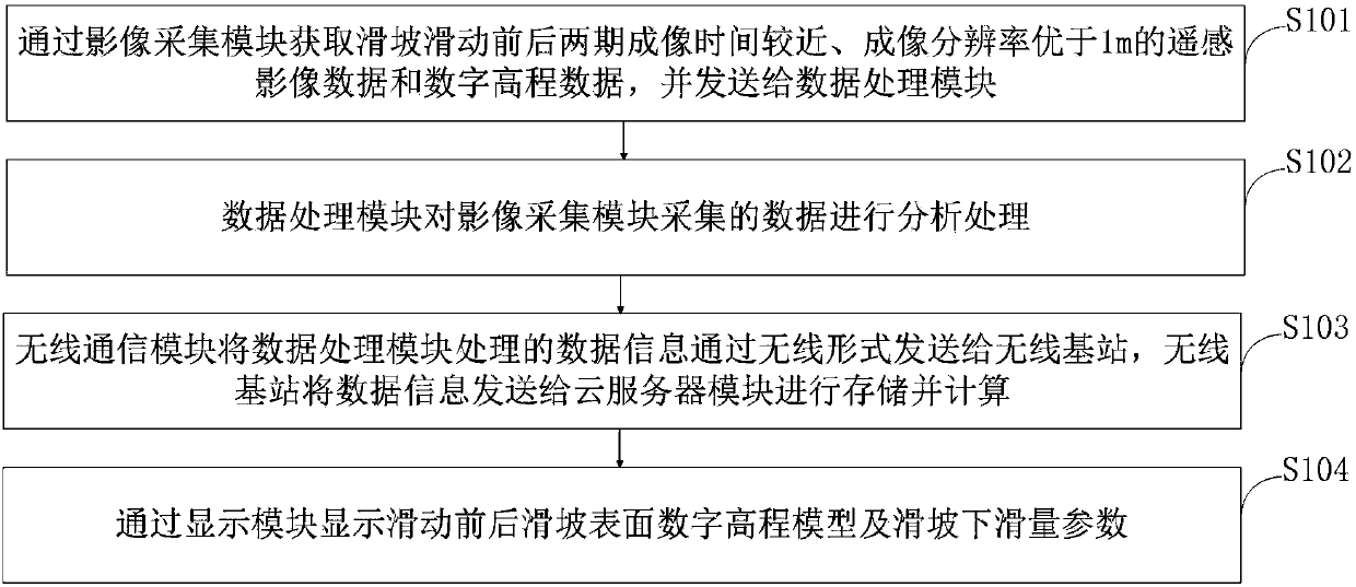
[0065] Such as figure 1 As shown, the large data-based landslide sliding parameter remote sensing rapid survey method provided by the embodiment of the present invention includes the following steps:

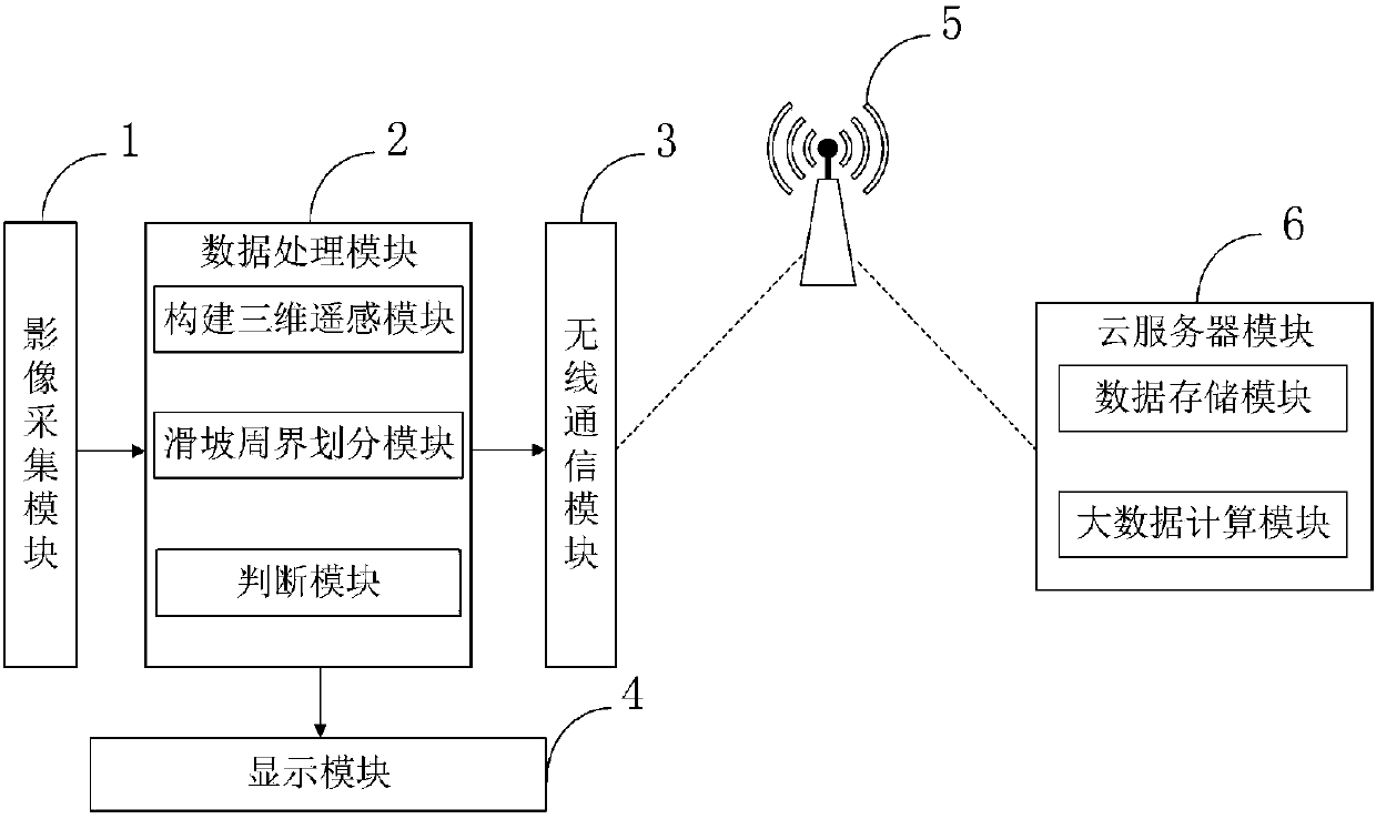
[0066] Step S101, the remote sensing image data and digital elevation data whose imaging time before and after the two phases of landslide sliding are relatively close and whose imaging resolution is better than 1m are acquired through the image acquisition module...


PUM


Abstract

The invention belongs to the technical field of remote-sensing surveying, and discloses a rapid remote-sensing exploration method for a landslide glide amount parameter based on big data. According tothe method, an image acquisition module is used for obtaining a remote-sensing image data and a digital elevation data with an imaging resolution being higher than 1 m as well as near imaging time before and after sliding of a landslide, the digital elevation data comprises a high resolution satellite image stereo image pair data and an elevation data obtained by airborne laser radar, a data processing module is used for analyzing the data collected by the image acquisition module, a wireless communication module is used for sending the data information processed by the data processing moduleto a wireless base station in a wireless form, the wireless base station sends the data to a cloud server module for storage and calculating, and a display module is used for displaying a landslide surface digital elevation model before and after sliding of the landslide as well as the landslide glide amount parameter. The method provides the data processing rate, a three-dimensional remote sensing module is constructed so that the constructed digital elevation model is visualized, and surveying is conveniently carried out.

Description

technical field [0001] The invention belongs to the technical field of remote sensing survey, and in particular relates to a remote sensing rapid survey method of landslide sliding amount parameters based on big data. Background technique [0002] Landslide refers to the soil or rock mass on the slope, affected by factors such as river scouring, groundwater activity, rainwater immersion, earthquake and artificial slope cutting, under the action of gravity, along a certain weak surface or weak zone, the whole or scattered The natural phenomenon of land sliding downhill. The moving rock (soil) body is called displacement body or sliding body, and the underlying rock (soil) body that has not moved is called sliding bed. With the increasing frequency of human activities, the construction of railways, highways, mines, water conservancy, factories and other projects has increased the probability of landslide disasters. However, the existing remote sensing survey technology is sl...

Claims


Application Information

Patent Timeline
Patent Type & Authority Applications(China)
IPC IPC(8): G01N21/17G06T7/10
CPCG01N21/17G01N2021/1793G06T7/10G06T2207/10032
Inventor 吴进良李修君吴瑞骐沈港
Owner CHONGQING JIAOTONG UNIVERSITY
Why Eureka
Try Eureka