Unmanned aerial vehicle-based real-time three-dimensional reconstruction method

A real-time 3D and unmanned aerial vehicle technology, applied in 3D modeling, image data processing, instruments, etc., can solve the problems of difficult matching of feature points, lack of real-time performance, slow matching speed, etc., achieve low cost and meet real-time 3D Reconstruction, surface smoothing effects

Active Publication Date: 2018-08-21
台州智必安科技有限责任公司 +1
View PDF8 Cites 20 Cited by
  • Summary
  • Abstract
  • Description
  • Claims
  • Application Information

AI Technical Summary

Problems solved by technology

[0007] (2) When the deflection angle between pictures is large or the light, season, etc. are different, it will be difficult to match the feature points;
[0008] (3) The feature matching speed is slow, very time-consuming, and not real-time
[0009] Using lidar to quickly scan the scene can efficiently and accurately obtain the information of the three-dimensional points of the scene, but the cost of lidar is high, and it is difficult to popularize and apply

Method used


Image

  • Unmanned aerial vehicle-based real-time three-dimensional reconstruction method
  • Unmanned aerial vehicle-based real-time three-dimensional reconstruction method
  • Unmanned aerial vehicle-based real-time three-dimensional reconstruction method

Examples


Embodiment Construction

[0071] The specific implementation manners of the present invention will be further described in detail below in conjunction with the accompanying drawings and embodiments. The following examples are used to illustrate the present invention, but not to limit the scope of the present invention.

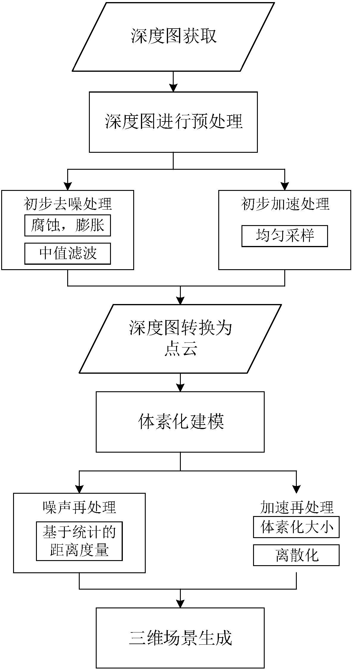
[0072] refer to Figure 1 to Figure 7 , a kind of real-time three-dimensional reconstruction method based on unmanned aerial vehicle of the present invention, comprises the following steps:

[0073] Step 1, obtain the depth data of the depth sensor and obtain the depth map;

[0074] The scene is captured by the binocular camera carried on the drone, and the depth data is obtained through the depth sensor according to the captured picture, and then the depth map of the scene is obtained; the captured image is a grayscale image with a size of 240*320; the depth data uses a xml file, as well as the UAV GPS data and yaw angle data obtained by the Guidence system. figure 2 and image 3...


PUM


Abstract

The invention discloses an unmanned aerial vehicle-based real-time three-dimensional reconstruction method. The method comprises the following steps of: 1, acquiring scene data, obtaining depth data through a depth sensor according to the acquired scene data, and obtaining a depth map; 2, carrying out noise preprocessing on the depth map obtained in the step 1, wherein the noise preprocessing comprises a morphological operation and a filtering operation; 3, carrying out acceleration processing on the noise preprocessed depth map, wherein the acceleration processing comprises carrying out uniform sampling on two-dimensional points in the noise preprocessed depth map; 4, converting the depth map accelerated in the step 3 into a point cloud; 5, modeling the point cloud obtained in the step 4;and 6, carrying out noise re-processing on the modeled point cloud obtained in the step 5, so as to realize three-dimensional reconstruction. According to the method, real-time three-dimensional reconstruction can be carried out on scenes, so that possibility is provided for subsequent intelligent processing of unmanned aerial vehicles and application of the unmanned aerial vehicles can be propelled.

Description

technical field [0001] The invention belongs to the technical field of unmanned aerial vehicle control, and in particular relates to a real-time three-dimensional reconstruction method based on an unmanned aerial vehicle. Background technique [0002] With the rapid development of information technology and the continuous maturity of equipment technology, there have been unmanned aerial vehicles, referred to as unmanned aerial vehicles (UAV). Because of its characteristics of non-contact, zero casualties, and long-term work, it has been widely used in military and civilian fields. [0003] From a technical point of view, drones can be divided into several categories: unmanned helicopters, unmanned fixed-wing aircraft, unmanned multi-rotor aircraft, unmanned airships, and unmanned paragliders. In the civilian field, UAVs can be used in aerial photography, news reports, environmental monitoring, express delivery, disaster monitoring, traffic patrols and power inspections, etc...

Claims


Application Information

Patent Timeline
IPC IPC(8): G06T17/00G06T5/00
CPCG06T5/002G06T17/005G06T2207/10028G06T2207/20036G06T2207/20032
Inventor 钱学明徐伟侯兴松邹屹洋
Owner 台州智必安科技有限责任公司
Why Eureka
Try Eureka