Building extraction method of using lidar data and remote-sensing image

A remote sensing image and laser radar technology, applied in the field of remote sensing information processing, can solve the problems of high degree of automation and difficulty in building extraction, and achieve the effect of high degree of automation, accurate detection, and improvement of detection accuracy

Inactive Publication Date: 2018-09-07
FUJIAN NORMAL UNIV
View PDF5 Cites 0 Cited by
  • Summary
  • Abstract
  • Description
  • Claims
  • Application Information

AI Technical Summary

Problems solved by technology

[0005] The invention provides a method for extracting buildings using laser radar data and remote sensing images, which can overcome the difficulty in extracting buildings in remote sensing images at present, make full use of the elevation information of laser radar data, and can directly separate low ground objects , improves the detection accuracy, can accurately detect building targets in remote sensing images, without manual intervention, and has a high degree of automation

Method used


Image

  • Building extraction method of using lidar data and remote-sensing image
  • Building extraction method of using lidar data and remote-sensing image
  • Building extraction method of using lidar data and remote-sensing image

Examples


Embodiment Construction

[0030] Specific embodiments of the present invention will be described in detail below in conjunction with the accompanying drawings.

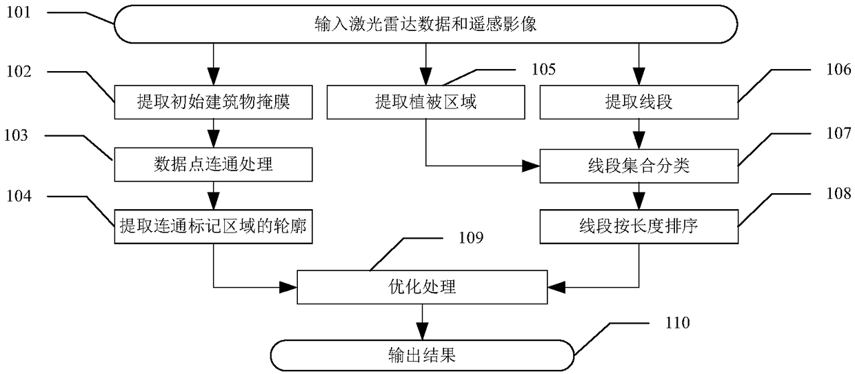
[0031] Step 101: Input lidar data (L) and remote sensing images (I) of the same area.

[0032] Step 102: Using the threshold (V t ) to extract the initial building mask (M) in L:

[0033] V t =V g +V r (3)

[0034] Equation (3), V g is the ground height, V r is the separation factor of high and low ground objects, when L(x,y)>V t , M(x,y)=1, when L(x,y)≤V t , M(x,y)=0, where (x,y) is the data point coordinates in L, where the ground height (V g ) is determined by the area covered by the remote sensing image (I). r ) is set to 1 meter.

[0035] Step 103: Connect data points to the initial building mask (M) in step 102 to obtain a set of connected labeled areas SET_Lablearea, the specific method is:

[0036] 103-a: Scan by row until a data point with M(x, y)=1 is searched, recorded as seed, and assigned a serial number Sqe, all data...


PUM


Abstract

The invention relates to a building extraction method of using lidar data and a remote-sensing image. The method comprises the following steps: step 1, inputting the lidar data and the remote-sensingimage of the same region; step 2, extracting an initial building mask; step 3, carrying out communication processing of data points; step 4, extracting contours of communication mark areas; step 5, extracting vegetation areas; step 6, extracting line segments; step 7, carrying out line segment set classification; step 8, sorting the line segments according to length; step 9, carrying out optimization processing; and step 10, outputting a result. Buildings in the remote-sensing image can be accurately extracted, and the method can be applied to updating of buildings in a geographic basic information database of an urban area.

Description

technical field [0001] The invention relates to the field of remote sensing information processing, in particular to a building extraction method using laser radar data and remote sensing images. Background technique [0002] Buildings are one of the main geographical elements of a city and an important content of various urban thematic maps. Researching the extraction of buildings is of great significance for comprehensively examining the urban geographic information environment. With the rapid development of high-resolution remote sensing image acquisition technology, the processing, analysis and application of remote sensing images have better data sources, and its digital products have wider and more in-depth applications. Various degrees of progress have been made in computer image processing technology, pattern recognition, artificial intelligence, etc., which provide the possibility to efficiently extract effective information from massive images. However, the extrac...

Claims


Application Information

Patent Timeline
Patent Type & Authority Applications(China)
IPC IPC(8): G06T7/13G06T7/187G06T7/246
CPCG06T2207/10032G06T7/13G06T7/187G06T7/246
Inventor 施文灶程姗
Owner FUJIAN NORMAL UNIV
Why Eureka
Try Eureka