Time synchronization and real-time data acquisition method for multi-sensor combined navigation system

An integrated navigation system and multi-sensor technology, which is applied in the field of time synchronization and data acquisition of real-time multi-sensor integrated navigation, can solve problems such as difficulty in implementation and poor generality, and achieve the effects of wide application, easy portability, and simple implementation.

Active Publication Date: 2018-09-11
WUHAN UNIV
View PDF6 Cites 15 Cited by
  • Summary
  • Abstract
  • Description
  • Claims
  • Application Information

AI Technical Summary

Problems solved by technology

In order to make the time synchronization accuracy meet the requirements by using software synchronization, it is often necessary to make the operating system meet the hard real-time requirements. Existing research mostly uses Linux based on RTAI, Xenomai and ot

Method used


Image

  • Time synchronization and real-time data acquisition method for multi-sensor combined navigation system
  • Time synchronization and real-time data acquisition method for multi-sensor combined navigation system
  • Time synchronization and real-time data acquisition method for multi-sensor combined navigation system

Examples


Example Embodiment

[0020] The specific technical solutions of the present invention will be described in detail below with reference to the drawings and embodiments.

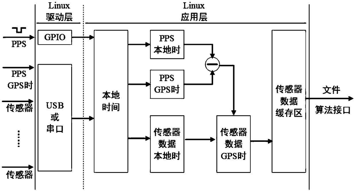
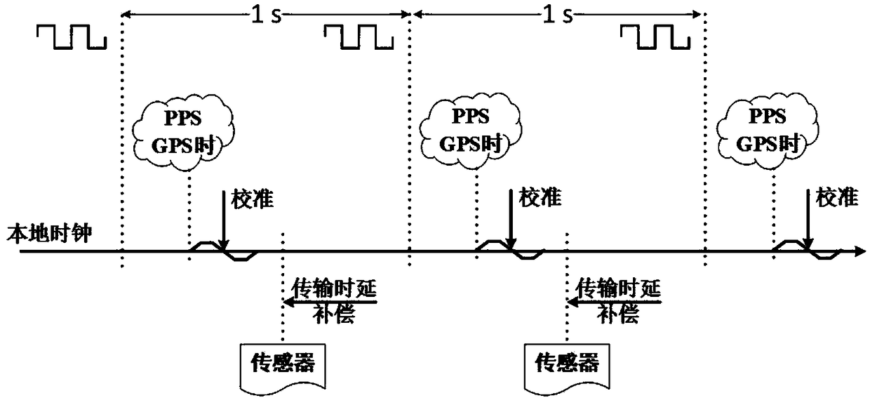
[0021] The present invention proposes that the real-time transformation of the standard Linux system is to make the operating system running on the computing carrier (such as the ARM development board) meet the hard real-time requirements; data collection and time synchronization are to make the time scale of the data collected by sensors such as IMU and odometer It is consistent with the standard GPS time, and then enters the designed buffer zone to prepare for integrated navigation data fusion. Specifically: Take the PPS signal output by the GPS receiver as a reference, correct the local clock of the calculation carrier, and then use the local calculation carrier The clock marks the time scale for other sensors.

[0022] The embodiments of the present invention are implemented as follows:

[0023] Firstly, the standard Linux kernel is...


PUM


Abstract

The invention relates to a time synchronization and real-time data acquisition method for a multi-sensor combined navigation system, comprising the steps that time synchronization is realized on the basis of a linux local clock, and real-time modification of a standard linux system is carried out, so that the operating system running on the computing carrier meets the hard real-time requirement; data acquisition and time synchronization are realized, so that the time marks of the data acquired by all the sensors are kept consistent with the standard GPS, then entering a buffer area and fusingthe combined navigation data to prepare the combined navigation data can be carried out; the data acquisition is synchronous with the time, and the implementation mode is as follows: the PPS signal output by the GPS receiver serves as a reference, the local clock of the calculation carrier is corrected, and then the time scale is marked by utilizing the local clock of the calculation carrier as other sensors. Under the condition that additional hardware is not needed, time synchronization precision within 10 ms can be achieved, the requirements of multi-sensor data fusion can be met, and programming is simple, application range is wide, and transplant is convenient.

Description

technical field [0001] The invention belongs to the field of multi-sensor integrated navigation, in particular to a time synchronization and data collection method for real-time multi-sensor integrated navigation. Background technique [0002] In complex ground environments such as urban canyons, GNSS signals cannot provide high-precision and reliable positioning and navigation services due to their susceptibility to occlusion and multi-path effects. preferred option. The inconsistency of data time scales due to the difference in the sampling time of each sensor data will introduce errors to the data fusion of integrated navigation and even lead to fusion errors. Therefore, solving the time synchronization problem of multi-sensor data, especially under real-time conditions, is to The key to optimal fusion of multiple sensors. [0003] At present, the time synchronization of real-time multi-sensor data is divided into two schemes. One is to use an external FPGA chip as a un...

Claims


Application Information

Patent Timeline
IPC IPC(8): G01S19/25G01S19/42
CPCG01S19/256G01S19/42
Inventor 张小红段睿朱锋
Owner WUHAN UNIV
Why Eureka
Try Eureka