Method for building three-dimensional terrain finite element model

A three-dimensional terrain and finite element technology, applied in special data processing applications, instruments, electrical digital data processing, etc., can solve the problem of inability to directly build a three-dimensional terrain model, and achieve the effect of lowering the threshold for use

Inactive Publication Date: 2018-09-11
SOUTH CHINA UNIV OF TECH
View PDF2 Cites 4 Cited by
  • Summary
  • Abstract
  • Description
  • Claims
  • Application Information

AI Technical Summary

Problems solved by technology

[0004] The present invention aims at the problem that the existing large-scale finite element software cannot directly construct a three-dimensional terrain model, and uses the characteristics of the COMSOL Multi

Method used


Image

  • Method for building three-dimensional terrain finite element model
  • Method for building three-dimensional terrain finite element model
  • Method for building three-dimensional terrain finite element model

Examples


Embodiment Construction

[0018] The present invention will be further described below in conjunction with specific embodiments.

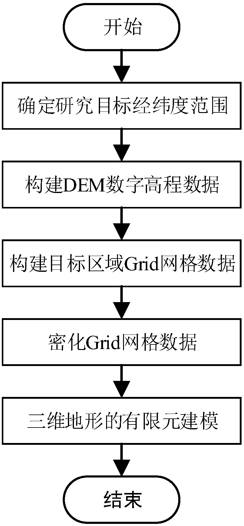
[0019] In this example, by improving the traditional modeling method and using the characteristics of the COMSOL Multiphysics software, a fast, high-precision, and high-efficiency method for establishing a three-dimensional terrain finite element model is proposed. Such as figure 1 As shown, the method includes the following steps:

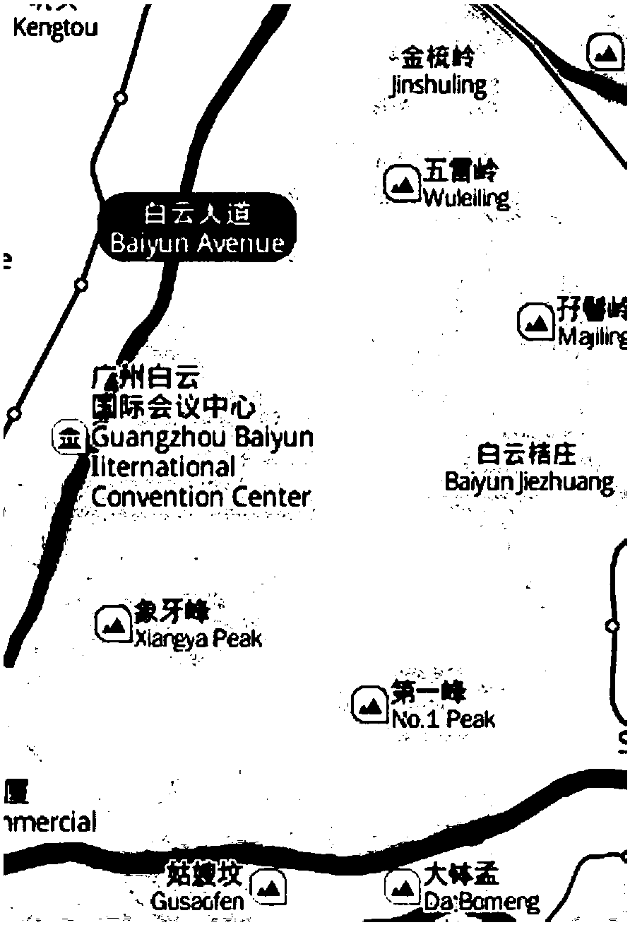
[0020] 1) Determine the latitude and longitude range of the research target: The research target is Baiyun Mountain in Guangzhou City, the longitude range is 113.2786°E–113.3174°E, and the latitude range is 23.1583°N–23.2171°N. map see figure 2 shown.

[0021] 2) Constructing DEM digital elevation data: refers to extracting vector data containing latitude and longitude information from the integrated remote sensing data, and constructing GDEMDEM 30M resolution digital elevation data by obtaining pairs from the Chinese Academy of Sciences da...


PUM


Abstract

The invention discloses a method for building a three-dimensional terrain finite element model. The method comprises the steps of 1, determining the longitudinal and latitude range of a research target; 2, constructing DEM digital elevation data; 3, constructing target region Grid data; 4, encrypting the Grid data; 5, performing finite element modeling on a three-dimensional terrain. By improvinga traditional modeling method, by means of characteristics of COMSOL Multiphysics software, the method for building the three-dimensional terrain finite element model is rapid and high in precision and efficiency.

Description

technical field [0001] The invention relates to the technical field of civil engineering and water conservancy, in particular to a method for establishing a three-dimensional terrain finite element model by using COMSOL Multiphysics software. Background technique [0002] At present, finite element has become an important tool for engineering numerical analysis. In the field of civil engineering, the numerical simulation of engineering problems such as slope stability and tunnel excavation can be carried out by using the finite element method. In the field of wind engineering research, fluid-solid coupling technology can be used to study the change phenomenon of fluid on the solid surface. For this type of research, it is difficult to fully reflect the essence of the problem with only two-dimensional models, and it needs to be applied to three-dimensional terrain finite element modeling technology. [0003] In the existing finite element software, such as ANSYS, ABAQUS, CO...

Claims


Application Information

Patent Timeline
IPC IPC(8): G06F17/50
CPCG06F30/23
Inventor 唐文虎杨毅豪牛哲文冯志颖辛妍丽
Owner SOUTH CHINA UNIV OF TECH
Why Eureka
Try Eureka