A method for positioning and navigation of UAV based on binocular vision

A positioning navigation and binocular vision technology, applied in image data processing, instruments, etc., can solve the problems of lack of height information, etc., and achieve the effects of strong anti-interference ability, good real-time performance, and strong stability

Active Publication Date: 2022-04-05
西安因诺航空科技有限公司
View PDF6 Cites 0 Cited by
  • Summary
  • Abstract
  • Description
  • Claims
  • Application Information

AI Technical Summary

Problems solved by technology

In the process of positioning and navigation based on vision, since the scene observed by the camera is a two-dimensional scene and lacks height information, there is great uncertainty in building and navigating a three-dimensional map through a two-dimensional scene alone.

Method used


Image

  • A method for positioning and navigation of UAV based on binocular vision
  • A method for positioning and navigation of UAV based on binocular vision
  • A method for positioning and navigation of UAV based on binocular vision

Examples


Embodiment Construction

[0055] The present invention provides a binocular vision-based method for positioning and navigating UAVs. The initial tracking target frame is input and optimized through user interaction, and a tracking model based on correlation filtering and target loss based on a random forest classifier are established. Retrieve the module to realize a long-term stable UAV target tracking method.

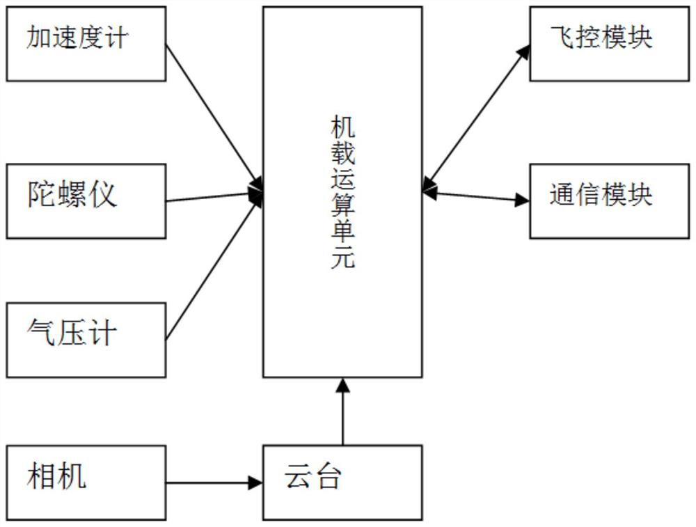
[0056] see figure 2 , UAV onboard control system includes gyroscope, accelerometer, barometer, gimbal, camera, flight control module, communication module and onboard computing unit, accelerometer is used to measure the three-axis acceleration of UAV; gyroscope is used It is used to measure the roll, yaw, and pitch angles of the UAV; the barometer is used to obtain the flight altitude of the UAV; the accelerometer, gyroscope and barometer are respectively connected to the onboard computing unit, and the camera is connected to the airborne computer via the gimbal. The computing unit is connec...


PUM


Abstract

The invention discloses a binocular vision-based positioning and navigation method for UAVs. According to the binocular camera of the UAV-borne control system, the left and right views of the image are obtained and the left and right views after the camera parameters have been corrected to obtain the depth information of the corresponding pixels. ; Extract the key points of the left view for filtering and screening; then find the matching key point set through optical flow tracking in the current frame, and obtain the matching key point pair; calculate the cost function according to the matching key point pair, and obtain the final pose result; The input continuous image frames are screened to obtain the key image frames, the joint cost function is calculated for the key point set and the pose of the key image frames, and the cost function is optimized to obtain the updated pose. The invention can quickly obtain reliable depth data through the binocular camera, and at the same time use the optical flow method to quickly calculate the matching relationship, with strong real-time performance and high algorithm robustness, and can complete UAV positioning and navigation work in indoor and outdoor large and medium-sized scenes .

Description

technical field [0001] The invention belongs to the technical field of unmanned aerial vehicles, and in particular relates to a method for positioning and navigating an unmanned aerial vehicle based on binocular vision. Background technique [0002] Visual positioning and navigation technology is a key technology in the field of computer vision, and has important applications in surveying and mapping, control, military and other fields. At the same time, it involves a number of core technologies in the field of computer vision, such as image processing, pattern recognition, automatic control, feature engineering, etc. It is a comprehensive technology. [0003] When UAVs are used to observe the ground in the air, it is often necessary to solve the problem of positioning and navigation when the UAV moves in an unknown environment, that is, how to determine its own movement through the observation of the environment when a UAV moves in an unknown environment trajectories while...

Claims


Application Information

Patent Timeline
Patent Type & Authority Patents(China)
IPC IPC(8): G06T19/00
CPCG06T19/003
Inventor 雍旭东方万元
Owner 西安因诺航空科技有限公司
Why Eureka
Try Eureka