Geometric cross-calibration method and system for spaceborne SAR images

A geometric calibration and image technology, applied in the field of geometric calibration, can solve problems such as unavailability of calibration technology, small number of geometric calibration fields, and reduced accuracy of satellite products

Active Publication Date: 2018-09-21
WUHAN UNIV
View PDF2 Cites 9 Cited by
  • Summary
  • Abstract
  • Description
  • Claims
  • Application Information

AI Technical Summary

Problems solved by technology

[0003] The traditional geometric calibration method relies on the high-precision control data of the geometric calibration field. Therefore, after the satellite is launched, it is necessary to collect images of the calibration field area to complete the geometric calibration. Only when the satellite successfully obtains the image of the calibration field area can it be carried out Geometric calibration, which c...

Method used


Image

  • Geometric cross-calibration method and system for spaceborne SAR images
  • Geometric cross-calibration method and system for spaceborne SAR images
  • Geometric cross-calibration method and system for spaceborne SAR images

Examples


Embodiment Construction

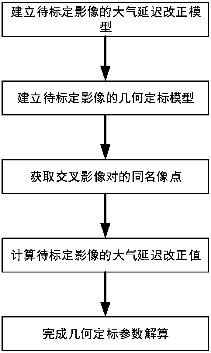
[0074] Such as figure 1 As shown, the spaceborne SAR image geometric cross calibration method of the present invention specifically includes the following steps:

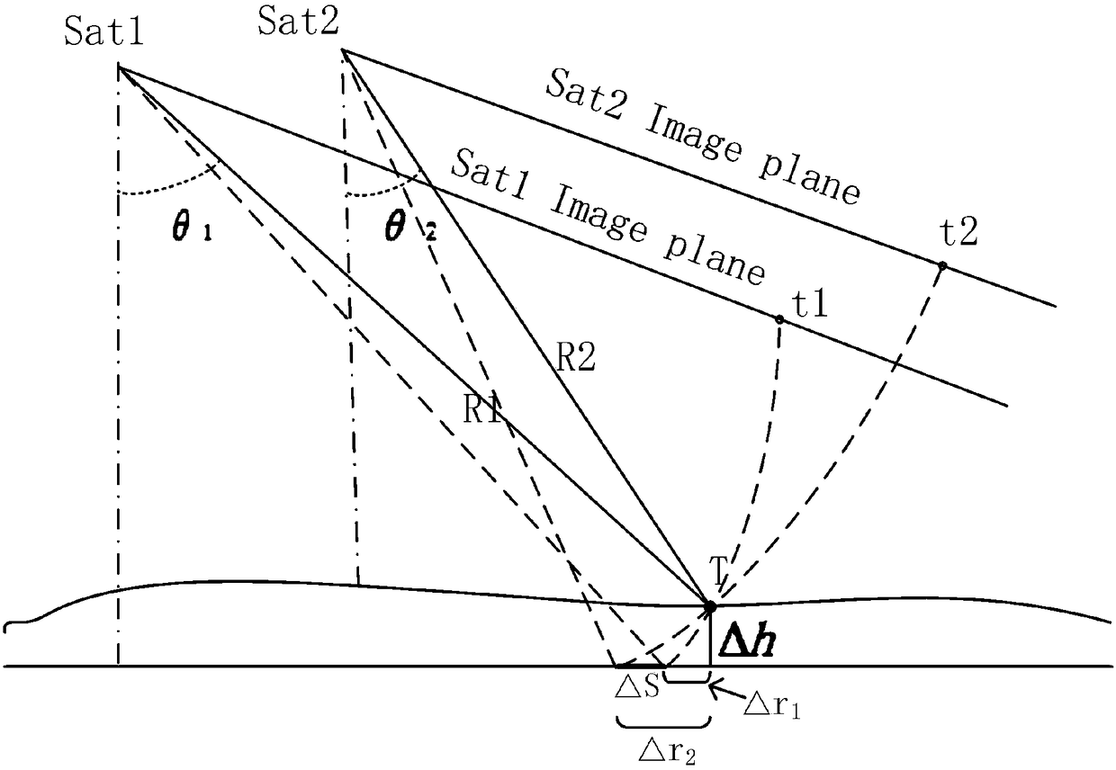
[0075] 1) Establish an atmospheric delay correction model for the image to be calibrated; the propagation of electromagnetic wave signals in the atmosphere follows Fermat's law, that is, the propagation time of the signal between any two points in space is minimized. It is known that the relationship between the propagation speed v of the radar observation signal in the atmosphere, the refractive index n, and the speed of light c in vacuum is n=c / v, and thus the propagation time delay of the radar observation signal in the atmosphere to the point z on the ground can be deduced for:

[0076]

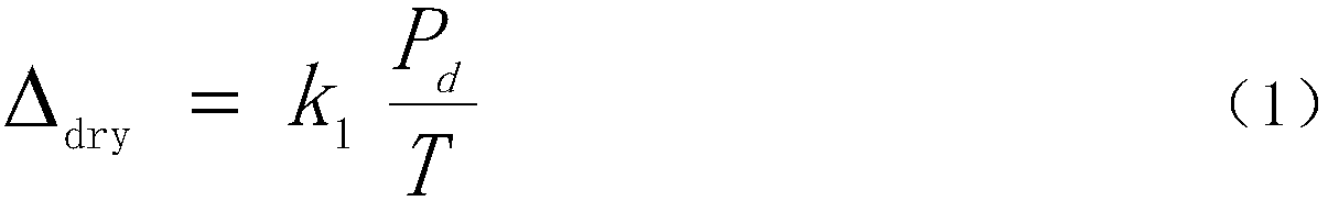
[0077] The atmospheric delay correction model is usually written as the product of the atmospheric zenith delay and the altitude angle correlation mapping function:

[0078]

[0079] Among them, n(z) is the atmospheric ...


PUM


Abstract

The invention relates to a geometric cross-calibration method and system for spaceborne SAR images. The method comprises the steps of step 1), establishing an atmospheric delay correction model of images to be calibrated; step 2) establishing a geometric calibration model of the images to be calibrated; step 3), selecting pairs of points with the same name from the images to be calibrated and reference images; step 4, according to imaging time of the images to be calibrated, using global atmospheric data provided by NCEP and ionospheric electron content distribution data provided by the European Orbit Determination Center (CODE), through the atmospheric delay correction model established in the step 1), calculating atmospheric delay correction values of the image to be calibrated; step 5),substituting the several pairs of points with the same name obtained in step 3) and the atmospheric delay correction values obtained in step 4) into the geometric calibration model established in step 2) to complete geometric calibration parameter solution. The method can achieve the normalization and short-period geometric calibration of a SAR satellite, do not need to arrange targets in advanceon the ground, and greatly save manpower and financial cost.

Description

technical field [0001] The invention relates to a geometric calibration method, in particular to a spaceborne SAR (Synthetic Aperture Radar) image geometric cross calibration method and system. Background technique [0002] Geometric calibration refers to the use of high-precision ground control data to accurately calibrate the geometric parameters of on-board imaging, which is of great significance for improving the geometric accuracy of satellite images. [0003] The traditional geometric calibration method relies on the high-precision control data of the geometric calibration field. Therefore, after the satellite is launched, it is necessary to collect images of the calibration field area to complete the geometric calibration. Only when the satellite successfully obtains the image of the calibration field area can it be carried out Geometric calibration, which cannot meet the needs of satellite normalization and rapid geometric calibration. In addition, the number of fix...

Claims


Application Information

Patent Timeline
IPC IPC(8): G01S7/40G01S13/90
CPCG01S7/40G01S13/90G01S13/9058
Inventor 张过邓明军赵瑞山徐凯郭风成
Owner WUHAN UNIV
Why Eureka
Try Eureka