Farmland identification method and system, unmanned aerial vehicle applied to agriculture

An identification method and farmland technology, applied in the agricultural field, can solve the problem of low identification accuracy of farmland, and achieve the effect of high identification accuracy and simple implementation process.

Active Publication Date: 2018-10-09
QIANXUN SPATIAL INTELLIGENCE INC
View PDF8 Cites 7 Cited by
  • Summary
  • Abstract
  • Description
  • Claims
  • Application Information

AI Technical Summary

Problems solved by technology

[0005] The embodiment of the present invention provides a farmland recognition method and device, and a drone used in agriculture, aiming to solve the problem of low farmland recognition accuracy in the prior art due to the influence of different factors on the farmland

Method used


Image

  • Farmland identification method and system, unmanned aerial vehicle applied to agriculture
  • Farmland identification method and system, unmanned aerial vehicle applied to agriculture
  • Farmland identification method and system, unmanned aerial vehicle applied to agriculture

Examples


Embodiment 1

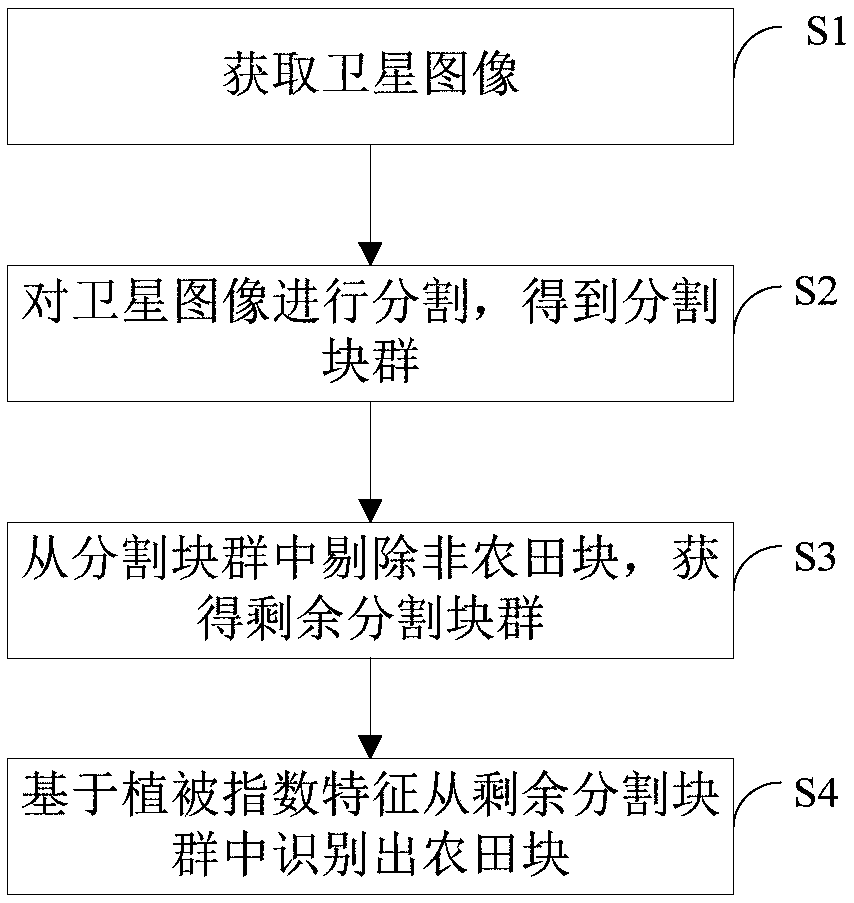
[0066] figure 1 It shows a flow chart of a farmland identification method provided by the first embodiment of the present invention, and the method includes:

[0067] Step S1, acquiring satellite images;

[0068]Specifically, the satellite image of the area where the farmland needs to be identified is first obtained, and the image can be taken by satellite to obtain a high-resolution image.

[0069] Step S2, segmenting the satellite image to obtain segmented block groups;

[0070] Specifically, the acquired satellite image is segmented to obtain a segmented block group, the segmented block group includes at least two segmented blocks, and in actual situations, the segmented block group includes multiple segmented blocks. The technology for segmenting the satellite image can adopt the existing segmentation technology, which will not be repeated here.

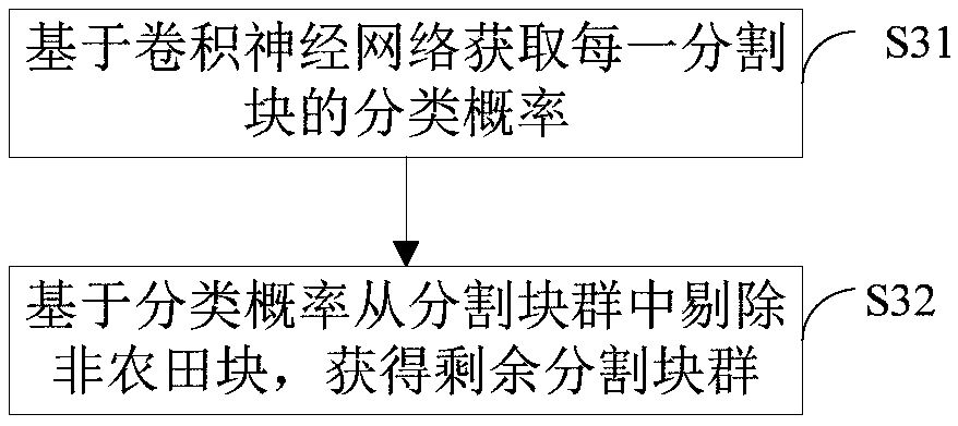
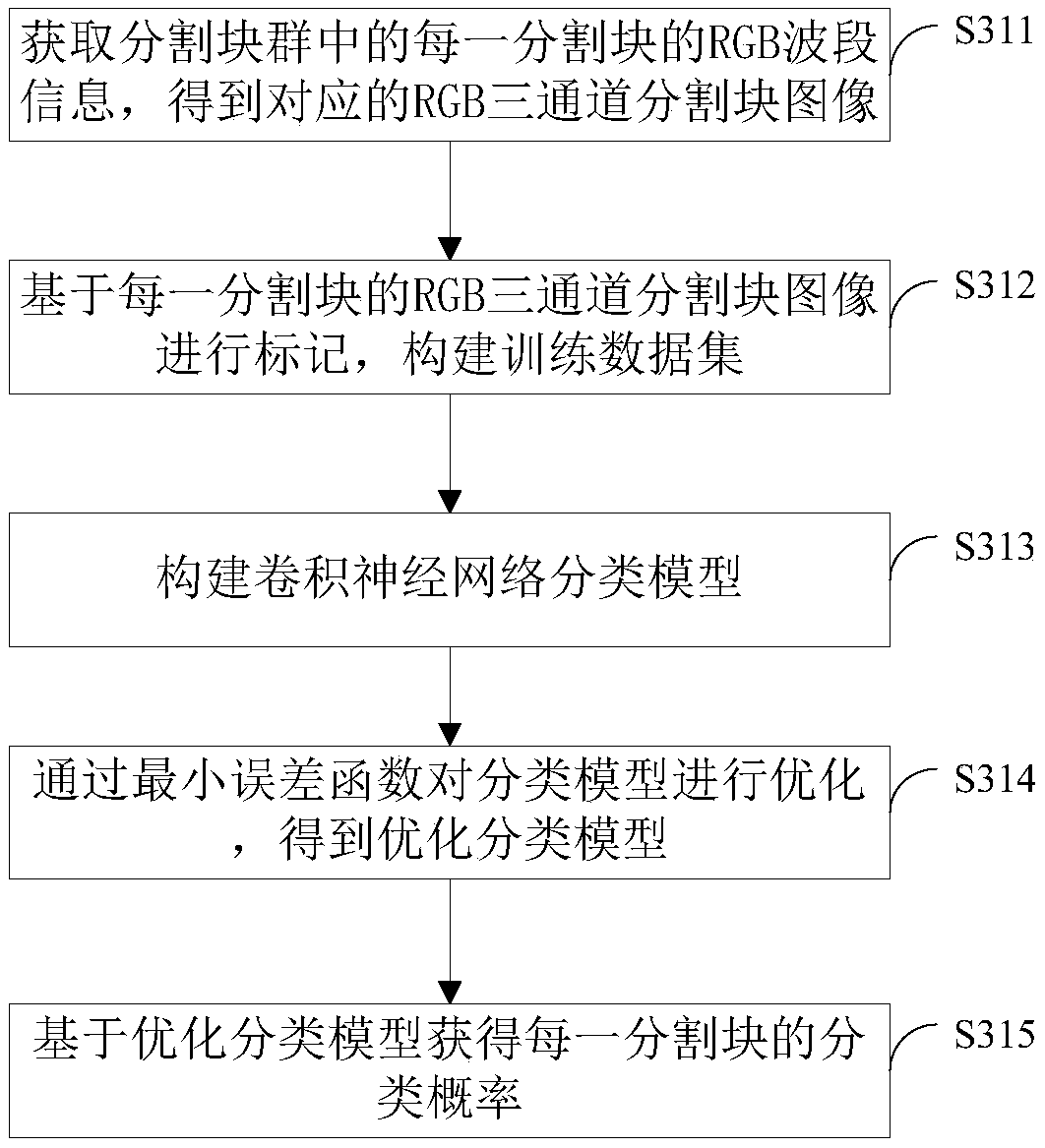
[0071] Step S3, removing non-farmland blocks from the segmented block group to obtain the remaining segmented block group; ...

Embodiment 2

[0129] Such as Figure 7 As shown, it is a structural diagram of a farmland identification system provided by the second embodiment of the present invention. The device includes: an acquisition unit 1, a segmentation unit 2 connected to the acquisition unit 1, a screening unit 3 connected to the segmentation unit 2, A recognition unit 4 connected to the screening unit 3, wherein:

[0130] An acquisition unit 1, configured to acquire satellite images;

[0131] Specifically, the satellite image of the area where the farmland needs to be identified is first obtained, and the image can be taken by satellite to obtain a high-resolution image.

[0132] The segmentation unit 2 is used to segment the satellite image to obtain segmented block groups;

[0133] Specifically, the acquired satellite image is segmented to obtain a segmented block group, the segmented block group includes at least two segmented blocks, and in actual situations, the segmented block group includes multiple s...

Embodiment 3

[0192] Figure 8 Shows a structural diagram of a service terminal provided by the third embodiment of the present invention, the service terminal includes: a memory (memory) 81, a processor (processor) 82, a communication interface (Communications Interface) 83 and a bus 84, the processing The controller 82 , the memory 81 , and the communication interface 83 complete mutual communication through the bus 84 .

[0193] Memory 81, used to store various data;

[0194] Specifically, the memory 81 is used to store various data, such as data during communication, received data, etc., which is not limited here, and the memory also includes multiple computer programs.

[0195] Communication interface 83, used for information transmission between communication devices of the service terminal;

[0196] The processor 82 is used to call various computer programs in the memory 81 to execute the farmland identification method provided in the first embodiment above, for example:

[0197] ...


PUM


Abstract

The invention provides a farmland identification method and system, and an unmanned aerial vehicle applied to agriculture, which are applicable to the technical field of agriculture. The identification method comprises the following steps of acquiring a satellite image; segmenting the satellite image to obtain a segmentation block group, wherein the segmentation block group at least comprises morethan two segmentation blocks; removing a non-farmland block from the segmentation block group, and obtaining a residual segmentation block group, wherein the residual segmentation block comprises atleast one segmentation block; identifying a farmland block from the residual segmentation block group based on vegetation index feature. The invention is advantageous in that firstly, the satellite image is segmented, and non-farmland blocks are preliminarily removed from the segmented block group, and then the farmland blocks are further identified from the residual segmentation block group basedon the vegetation index feature; the implementation process is simple and recognition accuracy is quite high.

Description

technical field [0001] The invention belongs to the technical field of agriculture, and in particular relates to a farmland identification method and system, and an unmanned aerial vehicle applied to agriculture. Background technique [0002] With the development of precise positioning technology, remote sensing technology and intelligent information processing technology, precision agriculture has become a development trend. Precise positioning of farmland blocks is the basis for precision agricultural applications such as unmanned planting, drone plant protection spraying, crop growth monitoring, and intelligent pest monitoring. [0003] At present, the geographical information of farmland blocks is basically collected manually, which has low efficiency and high cost, and the data distribution is scattered and the format is not uniform, so large-scale centralized management and update cannot be realized. The process of automatically extracting and discriminating farmland ...

Claims


Application Information

Patent Timeline
Patent Type & Authority Applications(China)
IPC IPC(8): G06K9/00
CPCG06V20/188
Inventor 赵一欣
Owner QIANXUN SPATIAL INTELLIGENCE INC
Why Eureka
Try Eureka