
Eureka
For R&D, Eureka makes reading and utilizing patents & technical documents easy.
Eureka AIR
Designed for self-driven R&D workflows. Generate viable solutions, solve complex R&D challenges, empower your innovation with AI.

Eureka Materials
Designed for material experts only. Revolutionize your material R&D, from search, analyze, to developing new materials.

TechResearch
Generate reliable direction feasibility study reports for your R&D in just a few steps.

TechSeek
Discover and master advanced knowledge NOW. Basics, ideas, possibilities, all at once.

TechMind
As an expert in R&D Theories, TechMind can generates customized viable solutions instantly.

TechRisk
Analyze your overall solution with one click, know your potential R&D risks in advance.

TechMonitor
Get weekly tech updates, stay abreast of the latest tech innovations and key insights.
Navigation and location service method based on big data system
A technology of location services and big data, applied in the field of navigation and location services based on big data systems, can solve the problems of user concurrency control, difficulty in mining value, and limitations, etc., to meet the needs of low-latency recommendation functions, complete routes and services Recommend and satisfy the effect of incremental analysis
- Summary
- Abstract
- Description
- Claims
- Application Information
AI Technical Summary
Problems solved by technology
Method used
Image

Examples
Embodiment 1
[0053] The present invention is described in detail below in conjunction with accompanying drawing:
[0054] Embodiments of the present invention provide a method for navigation and location services based on a big data system, including the following steps:
[0055] Step 1: Install Cloudera-Manager in the server, and use Cloudera-Manager to install distributed memory computing framework, distributed file system, data warehouse tools, log collection system and distributed message subscription system in the server system to form a big data system;
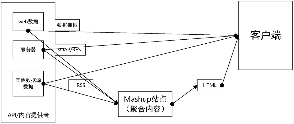
[0056] Step 2: Build a Mashup network aggregation platform;
[0057] Step 3: Utilize the Mashup network aggregation platform, the log collection system and the distributed message subscription system software to collect user sign-in information, and record the user sign-in information as original data;
[0058] Step 4: Perform data cleaning on the original data to obtain first data, and store the first data in the distributed file ...
Embodiment 2
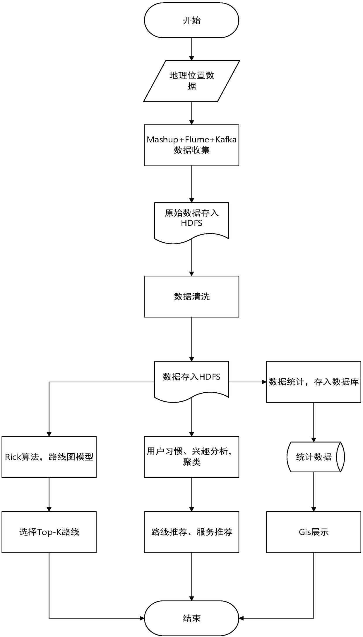
[0080] Such as figure 1 Shown, the basic process of the present invention is as figure 1 shown.
[0081] The first data is the geographical location data of the user, which is obtained by means of vehicle-mounted or mobile sensors and uploaded to the Internet through the network.
[0082] Use the network aggregation tool Mashup combined with the Flume log collection tool and the Kafka message system to collect location data information on the Internet and store them in the distributed file system HDFS. The collected original data is deduplicated to realize data cleaning, and the processed data Stored in HDFS.
[0083] The GIS display module reads data from HDFS, and uses the distributed computing framework to perform statistical analysis on these data. The analysis results are stored in Hive and relational databases according to the situation, and are called by the corresponding web application and combined with tools such as Baidu map. Visual display.
[0084] Cluster the...
example 1
[0105] Example 1: Route recommendation
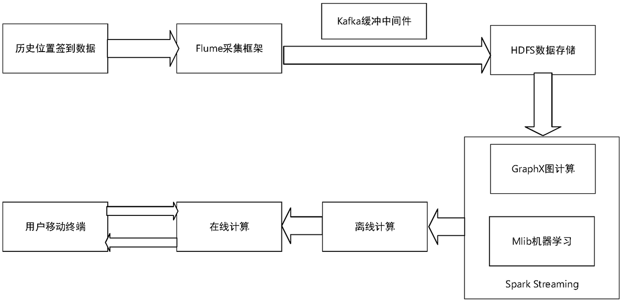
[0106] Such as image 3 As shown, the route recommendation implementation process is as follows:
[0107] Data collection: The design plan of the entire application is to track the browsing routes of historical users, use the user's check-in data in the scenic spot as the source of ST (space-time) data, further analyze and dig out valuable information, and use it as the basis for subsequent real-time route recommendation. We assume that at the same time, there will be hundreds of users clicking and signing in. We believe that the data source will generate a mega-level of data every 1-2 minutes. In order to ensure that the data can be collected completely and without errors, a Highly available data collection framework for data collection. Flume is a real-time log collection framework generated under such a technical requirement, which can well meet the conditions. Data needs to be stored in system files while data is being collected....
PUM
 Abstract
Description
Claims
Application Information
 - R&D Engineer
- R&D Manager
- IP Professional
- Industry Leading Data Capabilities
- Powerful AI technology
- Patent DNA Extraction
Browse by: Latest US Patents, China's latest patents, Technical Efficacy Thesaurus, Application Domain, Technology Topic, Popular Technical Reports.
© 2024 PatSnap. All rights reserved.Legal|Privacy policy|Modern Slavery Act Transparency Statement|Sitemap|About US| Contact US: help@patsnap.com