Sea chart aquiculture area recognition method based on multispectral remote sensing image

A multi-spectral image and remote sensing image technology, applied in the field of image processing and computer vision, can solve the problems of inability to dynamically obtain the distribution and location range information of large-scale offshore aquaculture areas, and label information of offshore aquaculture areas.

Active Publication Date: 2018-11-23
SHANGHAI MARITIME UNIVERSITY
View PDF9 Cites 19 Cited by
  • Summary
  • Abstract
  • Description
  • Claims
  • Application Information

AI Technical Summary

Problems solved by technology

[0006] The purpose of the present invention is to propose a sea chart based on multi-spectral remote sensing images for the current problem that the distribution and location range information of la

Method used


Image

  • Sea chart aquiculture area recognition method based on multispectral remote sensing image
  • Sea chart aquiculture area recognition method based on multispectral remote sensing image
  • Sea chart aquiculture area recognition method based on multispectral remote sensing image

Examples


Embodiment Construction

[0053] The implementation method will be described in detail below in conjunction with the accompanying drawings, and the present invention will be further elaborated.

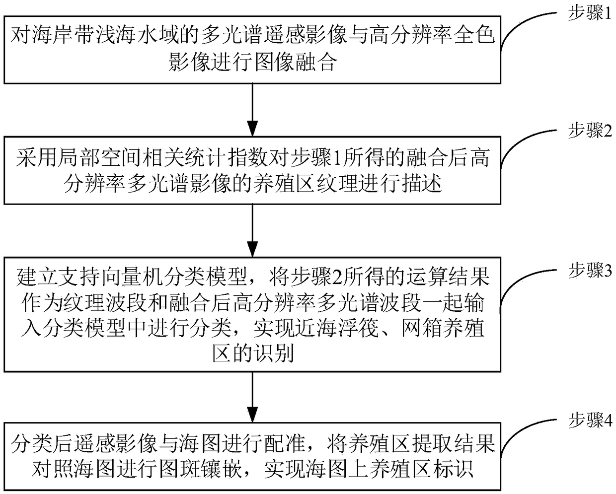
[0054] Step 1: Carry out image fusion of low-resolution multispectral remote sensing images and high-resolution panchromatic images of coastal shallow waters.

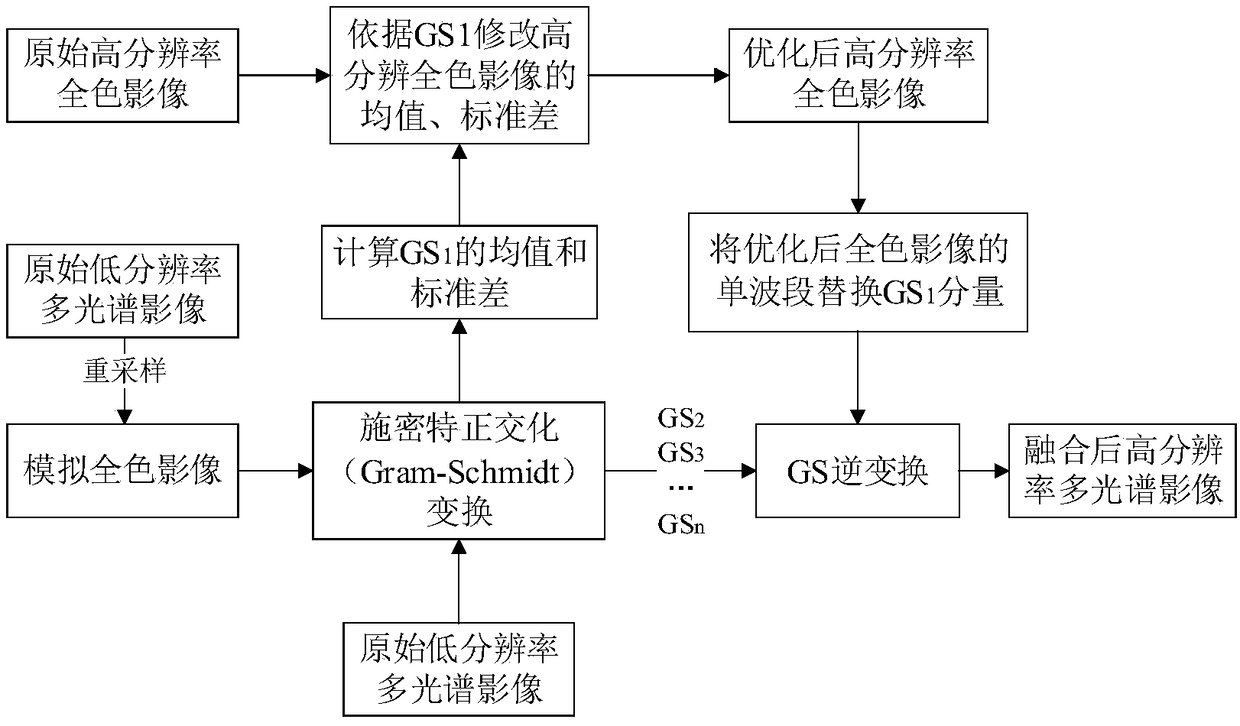
[0055] In order to ensure the fusion effect, the multi-spectral remote sensing images and high-resolution panchromatic images of coastal shallow waters are first preprocessed by atmospheric correction and spatial registration, so that the size of the multi-spectral bands is consistent with that of the panchromatic images; then, The Schmidt orthogonal transformation method is used to fuse panchromatic images and multi-spectral images to enhance the spatial resolution of the images, improve the accuracy of the images, increase the amount of information, and highlight the internal texture structure of the breeding area.

[0056] (1) The panchromatic image...


PUM


Abstract

The invention discloses a sea chart aquiculture area recognition method based on a multispectral remote sensing image. The method comprises the following steps of 1, performing image fusion on the multispectral remote sensing image and a high-resolution panchromatic image of a shallow water area of a coastal zone; 2, using a local space correlation statistical index to describe aquiculture area textures of the fused high-resolution multispectral image acquired in the step 1; 3, building a support vector machine classification model, using an operation result acquired in the step 2 to serve asa texture band and input into a classification model together with the fused high-resolution multispectral image for classification, and thus recognizing offshore floating rafts and net cage aquiculture areas; and 4, registering the remote sensing image with the sea chart after classification, performing pattern spot embedding on an aquiculture area extraction result by comparing with the sea chart, thus achieving identification of the aquiculture area on the sea chart. According to the method provided by the invention, the offshore aquiculture area can be objectively, accurately and dynamically monitored, and the method and the technical support are provided for further developing navigation monitoring and investigation work of distribution of the coastal aquiculture areas.

Description

Technical field: [0001] The invention relates to a sea chart breeding area identification method based on multi-spectral remote sensing images, which is used for multi-spectral remote sensing image analysis and target identification, and belongs to the field of image processing and computer vision. Background technique: [0002] With the development of my country's aquaculture industry, the scope of aquaculture areas in coastal areas has continued to expand, which has produced huge economic benefits, but also caused a lot of negative impacts on the ecological environment and maritime traffic. Every year, there are many incidents where merchant ships stray into breeding areas. Merchant ships entering the aquaculture area will, on the one hand, affect or partially destroy aquaculture, resulting in economic disputes; on the other hand, accidents of fishing nets being entangled with propellers may also occur, which will affect the safe navigation of ships. At present, the offsh...

Claims


Application Information

Patent Timeline
IPC IPC(8): G06K9/00G06K9/62G06T5/50
CPCG06T5/50G06V20/182G06V20/13G06F18/2411
Inventor 彭静陈淋淋肖文超丁雅玲王昊罗云
Owner SHANGHAI MARITIME UNIVERSITY
Why Eureka
Try Eureka