Monocular localization in urban environments using road markings

A technology of monocular and positioning method, applied in road network navigator, using re-radiation, re-radiation of electromagnetic waves, etc., can solve the problems of high cost of LiDAR, lack of direct distance measurement, etc.

Pending Publication Date: 2018-12-04
HONDA MOTOR CO LTD
View PDF5 Cites 5 Cited by
  • Summary
  • Abstract
  • Description
  • Claims
  • Application Information

AI Technical Summary

Problems solved by technology

However, LiDAR may be cost-prohibitive for large range ranging applications
On the other hand, cameras, while low cost and light weight, present challenges for visual mappin

Method used


Image

  • Monocular localization in urban environments using road markings
  • Monocular localization in urban environments using road markings
  • Monocular localization in urban environments using road markings

Examples


Embodiment Construction

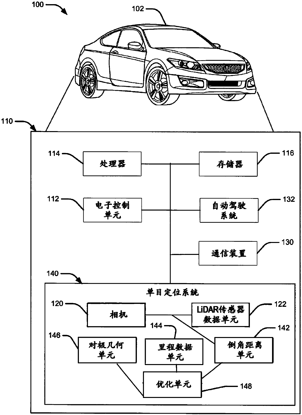
[0018] The following include definitions of selected terms used herein. The definitions include various instances and / or forms of components that are within the scope of the term and can be used for implementation. Examples are not limiting.

[0019] As used herein, a "processor" processes signals and performs general calculations and arithmetic functions. Signals processed by a processor may include digital signals, data signals, computer instructions, processor instructions, messages, bits, bit streams, or other computations that may be received, transmitted, and / or detected.

[0020] As used herein, a "bus" means an interconnection fabric operatively connected to transfer data between computer components in a single or multiple systems. A bus may be a memory bus, a memory controller, a peripheral bus, an external bus, a crossbar switch, and / or a local bus, among others. The bus may also be a vehicle bus that interconnects vehicle internal components using protocols such ...


PUM


Abstract

The invention relates to monocular localization in urban environments using road markings, in particular to methods and systems for monocular localization in urban environments. The method may generate an image from a camera at a pose. The method may receive a pre-generated map, and determine features from the generated image based on edge detection. The method may predict a pose of the camera based on at least the pre-generated map, and determine features from the predicted camera pose. Further, the method may determine a Chamfer distance based upon the determined features from the image andthe predicted camera pose, optimize the determined Chamfer distance based upon odometry information and epipolar geometry. Upon optimization, the method may determine an estimated camera pose.

Description

Background technique [0001] Autonomous vehicles have advanced significantly due to the expansion of perception, motion planning, and control, and / or the rise of perception technologies. For autonomous navigation, accurate positioning can be used. While a Global Positioning System ("GPS") may be used, in urban environments GPS systems may be affected by multipath effects. In GPS-challenged environments, alternative systems can be used for positioning. [0002] Localization can match sensor observations to a priori known maps. Maps can be generated by manual measurements or machine-mapped using different sensors. Cameras and light detection and ranging (“LiDAR”) are two common perception sensors. Since LiDAR generally provides accurate distance measurements, it can be used for mapping. A common approach might be to use LiDAR in the mapping and localization process. However, LiDAR can be cost-prohibitive for large-range ranging applications. On the other hand, cameras, whi...

Claims


Application Information

Patent Timeline
IPC IPC(8): G01C21/30G01S17/86G01S17/89
CPCG01C21/30G06T7/73G01S17/89G06T2207/30244G06T2207/30252G01S17/86G06T7/13
Inventor 陆彦黄嘉维陈奕廷B·海斯勒
Owner HONDA MOTOR CO LTD
Why Eureka
Try Eureka