A heat island simulation and forecast method of an urban planning scheme based on grey neural network CA model

A grey neural network and urban planning technology, applied in biological neural network models, special data processing applications, complex mathematical operations, etc. Computationally flexible effects

Inactive Publication Date: 2018-12-14
NANJING FORESTRY UNIV
View PDF2 Cites 4 Cited by
  • Summary
  • Abstract
  • Description
  • Claims
  • Application Information

AI Technical Summary

Problems solved by technology

[0005] Whether it is numerical models, urban canopies, or cellular automata, existing research is based on larger or smaller scales, and the WRF simulation scale is less than 3km 2 The resolution is difficult to accurately simulate, and the existing cellular automata models are also based on the 120m-scale surface heat island, mostly based on NDBI, DNVI and other indices, which cannot be connected with real cities to achieve real atmospheric temperature, and it is also difficult to match the actual planning The index connection of the design project, not to mention the practical application
Moreover, at present, neural networks and gray systems are used to study heat islands, most of which are based on time-based GM(1,1) models, and this model is also very unsuitable for simulation predictions based on current ground objects, because GM(1,1) The model is based on the prediction of the future based on time series data, while the prediction of the heat island is based on the prediction of the combined impact of multiple factors at the same time

Method used


Image

  • A heat island simulation and forecast method of an urban planning scheme based on grey neural network CA model
  • A heat island simulation and forecast method of an urban planning scheme based on grey neural network CA model
  • A heat island simulation and forecast method of an urban planning scheme based on grey neural network CA model

Examples


Embodiment 1

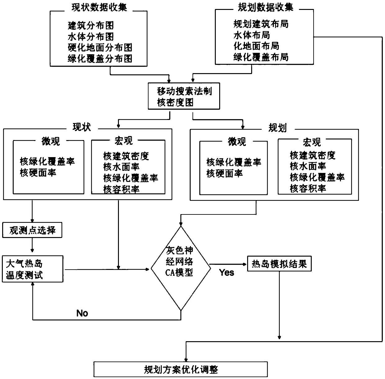
[0038] 1. Collect the data of the planned area to be evaluated, and select the weather test time and test location according to the following selection criteria: first, the heat island observation avoids the influence of rainfall; second, the average wind speed is close to 3m / s; third, consider building density, Factors such as volume ratio, hardened ground ratio, distance to water bodies, road density, green area ratio, etc., were considered both macroscopic factors and microscopic factors around the site, and 18 observation points were selected. According to the above criteria, 18 points in Tianjin were selected for testing (Table 1).

[0039] Table 1 Observation point name, number, coordinates, elevation

[0040]

[0041]

[0042] 2. Establish the regression equation

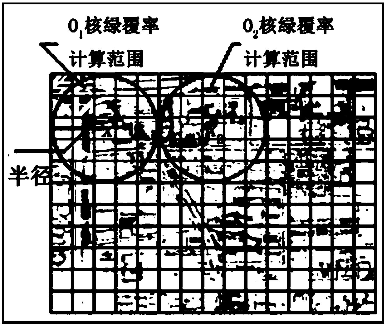
[0043] Use the test data and volume ratio, building density, green area ratio, water surface ratio, and hardened ground ratio (also known as nuclear volume ratio, nuclear building density, nuclear gree...

Embodiment 2

[0057] Select 20 test points in the Beijing case area, and the simulation and actual measurement contrast shows that the accuracy of the present invention is higher (such as Figure 6 and 7 shown). The 14:00 heat island intensity and simulation evaluation results show that the error is 0.09°C, and the average error is 1.4%. The 8:00-18:00 average heat island and simulation evaluation results show that the error is 0.12°C, and the average error is 3.5%.


PUM


Abstract

The invention provides a heat island simulation and forecast method of an urban planning scheme based on grey neural network CA model, which comprises the following steps: 1) collecting data of urbangreen space, hardened ground, building layout, volume ratio, building density and water body that affect the simulating and predicting of the heat island; 2) calculating and obtaining that kernel density of each factor in each divide area; 3) establishing a regression equation; according to the typical weather test results and regression parameters, using the grey neural network CA model to trainand verify the model, wherein the output results are the heat island effect of the simulation and prediction program. The invention provides a method for controlling and evaluating an outdoor thermalenvironment of a town. According to the spatial influence factors of urban heat island, the spatial distribution of urban heat island intensity at any time is simulated under the given meteorologicalconditions, so people can adjust the distribution of hardened ground such as building layout, green space layout and road square in urban planning according to the simulation results, which provides apowerful analysis tool for ecological town planning.

Description

technical field [0001] The invention relates to a method for simulating and predicting a heat island of an urban planning scheme based on a gray neural network CA model. Background technique [0002] Urban heat island (UHI) is a phenomenon in which cities are warmer than surrounding rural areas. In 1833, the British Howard (Howard) first proposed the urban heat island effect in the scientific magazine "London Climate". In the following 180 years, western countries carried out extensive research on urban heat islands, so there are endless literature on this aspect. The urban heat island effect varies with time and geographical location. The research on the heat island effect can be divided into two types according to the object: surface temperature and atmospheric temperature near the surface. In terms of research time, there are long-term change studies, annual change studies, and daily change studies. The scope of research ranges from hundreds of square kilometers at th...

Claims


Application Information

Patent Timeline
IPC IPC(8): G06F17/50G06F17/18G06N3/063
CPCG06F17/18G06N3/063G06F30/20Y02A30/60
Inventor 黄焕春运迎霞王世臻周婕李志刚
Owner NANJING FORESTRY UNIV
Why Eureka
Try Eureka