Underground high-precision navigation map establishment system and establishment method

A technology for navigation maps and construction methods, applied in directions such as road network navigators, can solve the problems of poor sensor effect, high price, and lack of construction methods and systems.

Active Publication Date: 2018-12-21
CHINA UNIV OF MINING & TECH
View PDF9 Cites 34 Cited by
  • Summary
  • Abstract
  • Description
  • Claims
  • Application Information

AI Technical Summary

Problems solved by technology

However, this type of technology usually requires expensive high-precision, multi-type sensors to provide accurate positioning information, and relies on sensor fusion technologies such as GPS and visual cameras. However, these sensors cannot be directly used in coal mines or have poor results due to the limitations of the working environment.
At present, the laser scanner used in the field of environmental surveying and mapping for roadway deformation measurement and roadway environment modeling has high precision, but it is expensive and must be s

Method used


Image

  • Underground high-precision navigation map establishment system and establishment method
  • Underground high-precision navigation map establishment system and establishment method
  • Underground high-precision navigation map establishment system and establishment method

Examples


Embodiment Construction

[0061] The specific implementation manners of the present invention will be further described in detail below in conjunction with the accompanying drawings.

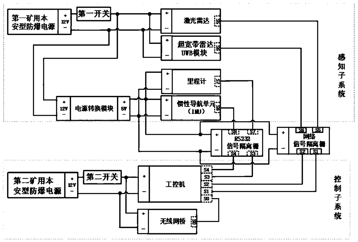
[0062] The present invention designs an underground high-precision navigation map construction system, which is used to realize the construction of an underground multi-level map model, including an underground geographic information system, an intrinsically safe modeling device, and various intrinsically safe ultra-wide bands arranged in each underground roadway The radar UWB anchor node and the reflection markers arranged in each underground roadway are used to determine the accuracy of the underground multi-level map model.

[0063] Among them, such as figure 1 As shown, the intrinsically safe modeling device includes laser radar, ultra-wideband radar UWB module, odometer, inertial navigation module, the first mine intrinsically safe explosion-proof power supply, the second mine intrinsically safe explosion-proof powe...


PUM


Abstract

The invention relates to an underground high-precision navigation map establishment system and an establishment method. On the basis of the system comprising an underground geographic information system, an intrinsically safe modeling device and each intrinsically safe ultra wide band (UWB) anchor node which is set in each underground tunnel, the establishment method is further designed and introduced. According to the whole design, an underground high-precision navigation map can be rapidly established, environment model functions can be dynamically updated, a modeling result is input into the underground geographic information system, and a multilayer map model capable of providing auxiliary positioning and route planning for automatic movement of vehicles underground is established.

Description

technical field [0001] The invention relates to an underground high-precision navigation map construction system and a construction method, belonging to the technical field of coal mine environment modeling. Background technique [0002] Automation and intelligence are the development trend of underground mobile equipment, and positioning and navigation technology is the key to achieve the above goals. At present, the underground positioning technology mainly focuses on the positioning of track-type equipment such as coal shearers, scraper machines, and mine cars, as well as personnel positioning. Usually, encoders or inertial devices are used for dead reckoning and radio frequency positioning. Underground construction equipment and robots currently used for support, rock drilling, loading, shoveling, drilling, gas extraction, coal mining and rescue still mainly rely on manual driving or remote control operation, which is highly dangerous and labor-intensive. Auxiliary tran...

Claims


Application Information

Patent Timeline
IPC IPC(8): G01C21/32
CPCG01C21/32
Inventor 朱华李猛钢葛世荣由韶泽陈常汪雷唐超权
Owner CHINA UNIV OF MINING & TECH
Why Eureka
Try Eureka