Eureka AIR delivers breakthrough ideas for toughest innovation challenges, trusted by R&D personnel around the world.

Laser radar data fusion method

A laser radar, data technology, applied in the direction of re-radiation of electromagnetic waves, utilization of re-radiation, measurement devices, etc., can solve the problem of ignoring echo signals and other problems

Active Publication Date: 2018-12-21
TIANJIN UNIV
View PDF11 Cites 7 Cited by
  • Summary
  • Abstract
  • Description
  • Claims
  • Application Information

AI Technical Summary

Problems solved by technology

The existing methods have made improvements in the direction of fusing visible light images and point cloud data based on distance information, but they have ignored the application of the echo signal intensity information generated by the pulse laser radar system (LIDAR). The signal intensity information is related to the reflectivity, material, and texture of the target reflective surface, which can reflect rich target object information, and has intrinsic correlation with the echo distance information

Method used


Image

  • Laser radar data fusion method
  • Laser radar data fusion method
  • Laser radar data fusion method

Examples


Embodiment Construction

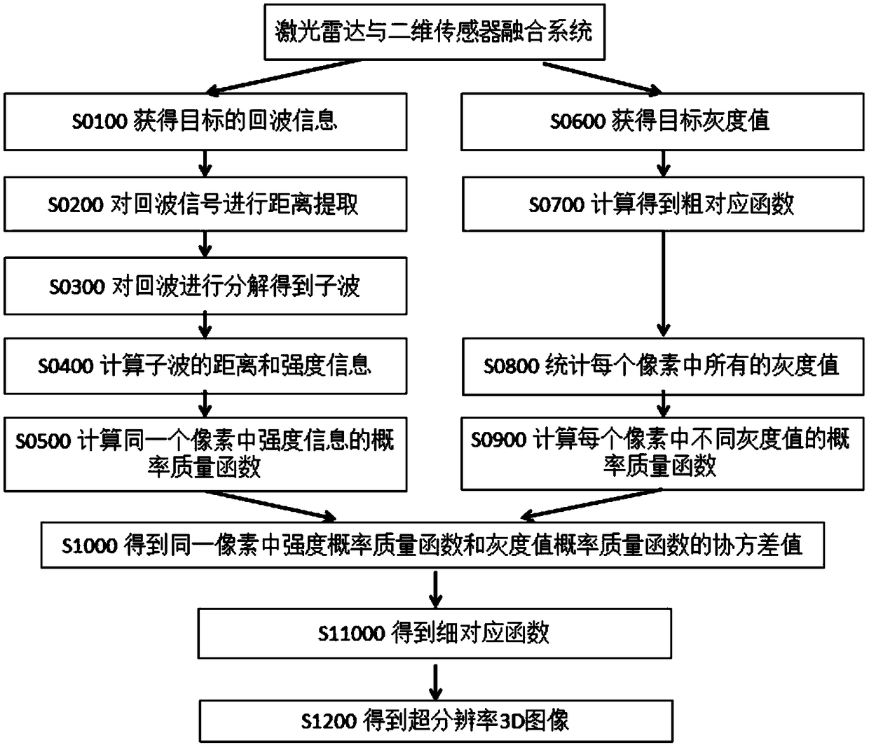
[0034] The invention is a data fusion algorithm based on a pulse laser radar and a two-dimensional plane sensing system. The two-dimensional plane sensing system in the present invention refers to a visible light sensing system and an infrared sensing system, which can obtain two-dimensional plane grayscale information. Obtain more detailed distance information and intensity information by decomposing pulse lidar echoes, normalize the distance information, intensity information, and grayscale information, and then perform data fusion, which can increase the 3D image resolution of lidar by 5 times to 10 The multiplier is related to the material, reflectivity, texture of the target object, and the light intensity and temperature of the environment where the system is located.

[0035] Technical scheme of the present invention is:

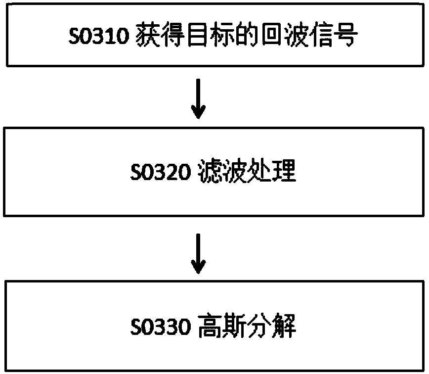
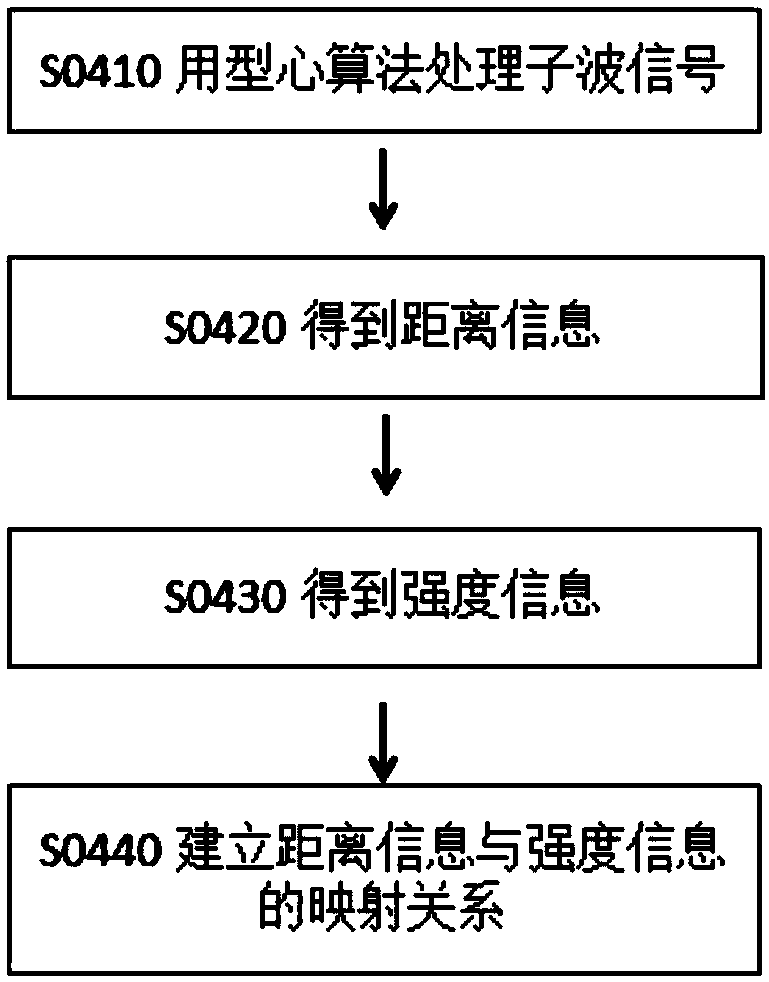
[0036] Step 1: Obtain the echo information of the target in the field of view through the pulse lidar, including distance information and intensity ...


PUM


Abstract

The invention relates to a pulsed laser radar and a two-dimensional planar sensing system and data processing so that the resolution of a 3D image based on a laser radar system can be improved while the complexity of the original pulsed laser radar system is not increased. According to the invention, a laser radar data fusion method comprises: extracting echo information and distance information and carrying out decomposition and analysis; calculating a probability mass function of each piece of intensity information i; acquiring a fine correspondence matrix F(d<M>N,G<alpha>beta of distance information d<M>N and gray information G<alpha>beta in a same pixel; and acquiring a 3D image with the resolution exceeding the inherent resolution of the pulsed laser radar. According to the invention,the laser radar data fusion method is mainly applied to data processing occasions for the pulsed laser radar and the two-dimensional planar sensing system.

Description

technical field [0001] The invention relates to a pulse laser radar, a two-dimensional plane sensing system and data processing, specifically, a laser radar data fusion method. Background technique [0002] Lidar can realize automatic navigation and 3D mapping through ranging, and can be widely used in autonomous driving, drones, terrain mapping, security, monitoring and other fields. However, due to the limitations of current technology, the environmental adaptability and image resolution of lidar need to be improved, and the integration of lidar with other types of sensing systems is an effective way to make up for its shortcomings. [0003] In 2014, a feature-based fusion method of airborne laser point cloud and image data appeared, which is easy to implement and has high accuracy of fusion effect. In 2017, many technologies related to lidar information fusion appeared, including point cloud and planar image fusion methods and devices. It is only necessary to determine t...

Claims


Application Information

Patent Timeline
Patent Type & Authority Applications(China)
IPC IPC(8): G01S17/06G01S7/48
CPCG01S7/4802G01S7/4808G01S17/06
Inventor 赵毅强夏显召李杰陈瑞
Owner TIANJIN UNIV
Why Eureka
Eureka Blog
Learn More