Satellite Remote Sensing Image Recognition of Water Body

A remote sensing image and satellite remote sensing technology, which is applied in the field of water body identification in satellite remote sensing images, can solve the problems of low quality, low extraction accuracy and low signal-to-noise ratio of water body target information extraction.

Inactive Publication Date: 2018-12-25
国网新疆电力有限公司信息通信公司 +1
View PDF2 Cites 9 Cited by
  • Summary
  • Abstract
  • Description
  • Claims
  • Application Information

AI Technical Summary

Problems solved by technology

[0004] The present invention provides a method for water body identification in satellite remote sensing images, which overcomes the deficiencies in the prior art above, and can effectively solve the problem of low accuracy and low signal-to-noise ratio of water body information extraction methods for high-resolution images in existing satellite remote sensing image water body information extraction methods. Low, causing the problem of low quality of water body target information extraction

Method used


Image

  • Satellite Remote Sensing Image Recognition of Water Body
  • Satellite Remote Sensing Image Recognition of Water Body
  • Satellite Remote Sensing Image Recognition of Water Body

Examples


Embodiment 1

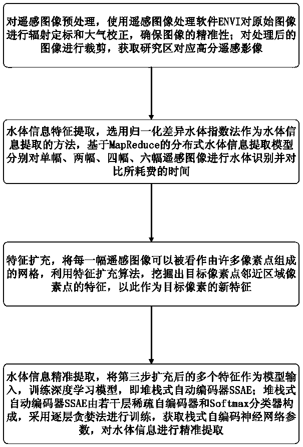
[0049] Example 1: as attached figure 1 , 2 , 3, and 4, the method for identifying water bodies in satellite remote sensing images includes the following steps:

[0050]The first step is to preprocess the remote sensing images, and use the remote sensing image processing software ENVI to perform radiometric calibration and atmospheric correction on the original images to ensure the accuracy of the images; crop the processed images to obtain high-scoring remote sensing images corresponding to the study area. Supervised classification of high-scoring remote sensing images with the help of remote sensing image processing software ENVI, using the maximum likelihood method as the classification basis;

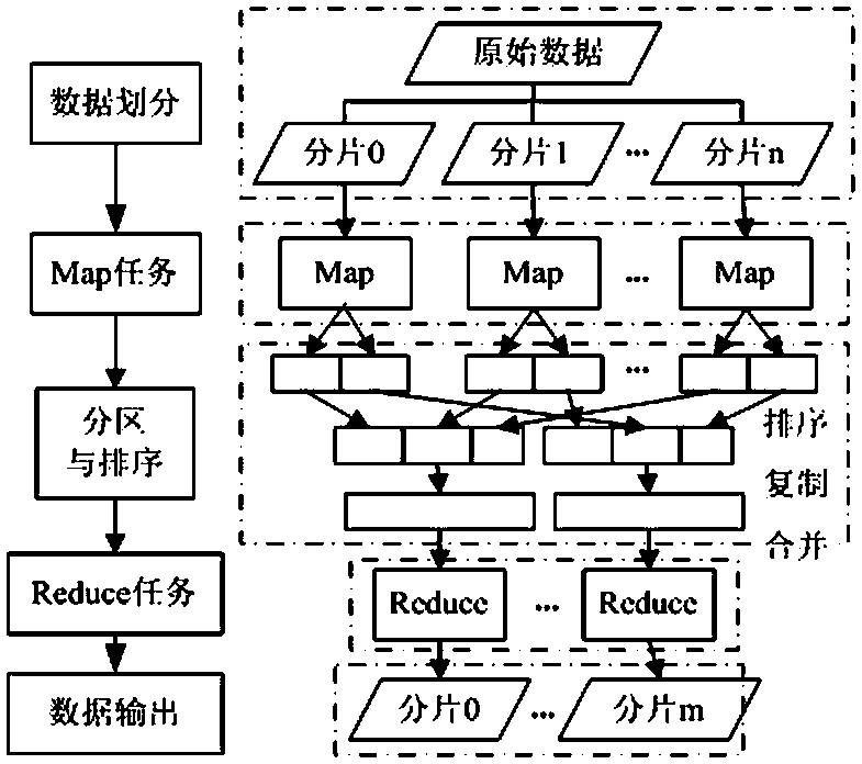
[0051] In the second step, water body information feature extraction, the normalized difference water body index method is selected as the method for water body information extraction, and the distributed water body information extraction model based on MapReduce is used to extract ...

Embodiment 2

[0081] Example 2: as attached Figure 5 , 6 , 7, 8 and Tables 1, 2, 3, 4, and 5, three areas with different topography were selected as the study areas to evaluate the robustness of the proposed water body information extraction model; each area has a typical Geographical characteristics, Table 1 presents the details of the study area.

[0082] Xinjiang Uygur Autonomous Region is located at 34° 25' to 48° 10' north latitude and 73° 40' to 96° 18' east longitude, with an area of ​​about 1.66 million square kilometers. Xinjiang is dry and rainy all year round, forming an obvious temperate continental arid climate. The entire Xinjiang region is home to more than 500 rivers, including the Tarim River, China's largest inland river, and the Ili River, which spans China and Kazakhstan. Therefore, the focus of water body information extraction in Xinjiang is to distinguish between water bodies and arid soils.


PUM


Abstract

The invention relates to the technical field of remote sensing image processing, which is a water body identification method of satellite remote sensing image. The first step is remote sensing image preprocessing. The second step is feature extraction of water information, wherein the normalized difference water index method is selected as the method of water information extraction. Thirdly, the feature of pixel points in the vicinity of target pixel points is extracted by using the feature expansion algorithm, which is used as the new feature of target pixel. In the fourth step, the extendedfeatures of the third step are used as model inputs to train the depth learning model, and the layer-by-layer greedy method is used to train the model to obtain the parameters of the stack-type self-coding neural network, and then the water information is extracted precisely. The invention constructs a water body information extraction model based on depth learning, relates to the association characteristics of adjacent pixel points and target points in an image, designs and realizes a feature expansion algorithm, connects the original features and the expanded features of the image, trains the depth learning model together, and realizes the accurate extraction of water body information.

Description

technical field [0001] The invention relates to the technical field of remote sensing image processing, and relates to a method for identifying water bodies in satellite remote sensing images. Background technique [0002] With the development of remote sensing technology, the significant improvement of satellite image resolution (including spatial, temporal, and spectral resolution), and the continuous improvement of image correction, enhancement, fusion and other processing technologies, the monitoring of various ground objects on the earth's surface can not be affected. Due to geographical location, weather and man-made constraints, remote sensing technology is increasingly showing its unique superiority. Among them, the extraction of water body information from remote sensing images plays a very important role in water resources investigation, flood disaster prediction and assessment, water conservancy planning, and environmental monitoring. The imaging period of remote...

Claims


Application Information

Patent Timeline
Patent Type & Authority Applications(China)
IPC IPC(8): G06K9/00G06K9/62
CPCG06V20/13G06F18/24
Inventor 杨柳赵明君王晓磊胡红艳何伟冯磊王辉马斌徐玺翔刘权李雅洁李志刚胡美慧王楷景康王冰张烜
Owner 国网新疆电力有限公司信息通信公司
Why Eureka
Try Eureka