Doppler radar sea surface speed measurement error correction method
A Doppler radar and error correction technology, applied in the field of radar, can solve the problems of easy fatigue of pilots, large error in speed measurement accuracy, and inability to correct, so as to simplify the operation complexity, improve the speed measurement accuracy, and increase the effect of correction.
- Summary
- Abstract
- Description
- Claims
- Application Information
AI Technical Summary
Problems solved by technology
Method used
Image
Examples
Embodiment 1
[0041] Embodiment 1, given the sea surface wind data, the correction amount is calculated:
[0042] refer to figure 1 , the implementation steps of this embodiment are as follows
[0043] Step 1, set the "Land / Sea" switch mode.
[0044] The carrier aircraft sets the corresponding switch mode according to the flight area, that is, when the carrier aircraft is flying over land, the pilot sets the "land / sea" switch to "land" mode; / Sea" switch to "Ocean" mode. When the Doppler radar beam tracking on the carrier aircraft is normal, the radar outputs the three-axis velocity in the body coordinate system, the forward velocity V x , Lateral velocity V y , vertical velocity V z .
[0045] This example is mainly for the carrier aircraft flying over the sea, that is, the "Land / Sea" switch is set to "Ocean" mode.
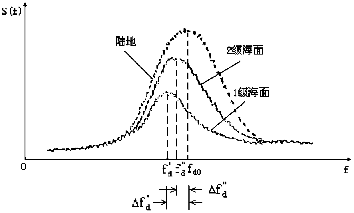
[0046] Step 2, correcting the speed measurement error caused by the echo spectrum distortion.
[0047] When the carrier aircraft is flying over the sea, for the Dopple...
Embodiment 2
[0078] Embodiment 2, the unknown ocean surface wind data, the correction amount is calculated
[0079] refer to figure 2 , the implementation steps of this embodiment are as follows
[0080] Step 1, set the "Land / Sea" switch mode.
[0081] Step 2, correcting the speed measurement error caused by the echo spectrum distortion.
[0082] Step 3, obtaining the correction amount of the speed measurement error caused by the ocean current relative to the geographic coordinate system.
[0083] The specific implementation of the above three steps is the same as that of Step 1-Step 3 in Embodiment 1.
[0084] Step 4. Automatically derive ocean surface wind data and calculate the correction amount
[0085] 4.1) When there is no sea surface wind data and the altitude of the aircraft is not greater than 3000 feet, the Doppler radar firstly needs to be based on the altitude Hp of the aircraft and the air wind speed V displayed by the aircraft instrument. aw , air wind direction D aw , l...
PUM
 Abstract
Description
Claims
Application Information
 - R&D
- Intellectual Property
- Life Sciences
- Materials
- Tech Scout
- Unparalleled Data Quality
- Higher Quality Content
- 60% Fewer Hallucinations
Browse by: Latest US Patents, China's latest patents, Technical Efficacy Thesaurus, Application Domain, Technology Topic, Popular Technical Reports.
© 2025 PatSnap. All rights reserved.Legal|Privacy policy|Modern Slavery Act Transparency Statement|Sitemap|About US| Contact US: help@patsnap.com


