
Measurement method of amount of fill and amount of excavation of engineering by unmanned aerial vehicle

A measurement method and unmanned aerial vehicle technology, applied in the direction of volume measurement instruments/methods, container/cavity measurement, measurement devices, etc., can solve problems such as complexity and large errors, achieve less earthwork volume, speed up construction progress, The effect of improving design efficiency and accuracy

Inactive Publication Date: 2019-01-01
中铁贵州工程有限公司
View PDF3 Cites 8 Cited by
  • Summary
  • Abstract
  • Description
  • Claims
  • Application Information

AI Technical Summary

Problems solved by technology

Different from the method of allocating earth and rocks in the plane area, not only the space area allowed to pile up soil in the plane, but also the influence of the slope of the terrain must be considered. In addition, according to the overall construction arrangement sequence of the project building, the pre-construction cost estimate must be taken into account. Carry out earthwork measurement first. The current test method is too complicated and has large errors. Under the condition of ensuring safety, reduce the impact of earthwork stacking on construction and transportation

Method used


Image

  • Measurement method of amount of fill and amount of excavation of engineering by unmanned aerial vehicle

Examples


Embodiment Construction

[0024] The technical solutions in the embodiments of the present invention will be clearly and completely described below in conjunction with the accompanying drawings in the embodiments of the present invention. Obviously, the described embodiments are only a part of the embodiments of the present invention, rather than all the embodiments. Based on the embodiments of the present invention, all other embodiments obtained by a person of ordinary skill in the art fall within the protection scope of the present invention.

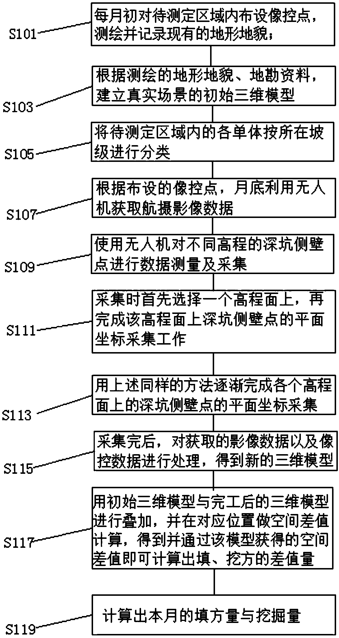
[0025] According to an embodiment of the present invention, a method for measuring the filling amount and excavation amount of the drone engineering is provided.

[0026] Such as figure 1 As shown, a method for measuring fill and excavation in UAV engineering according to an embodiment of the present invention includes the following steps:

[0027] Step S101, arranging image control points in the area to be measured at the beginning of each month, surveying, mappin...


PUM


Abstract

The invention discloses a measurement method of amount of fill and amount of excavation of engineering of an unmanned aerial vehicle. The measurement method comprises the following steps: laying photo-control points in a to-be-measured region at the beginning of each month, mapping and recording the existing landform, establishing an initial three-dimensional model of a real scene according to themapped landform and geological exploration document, classifying various monomers in the to-be-measured region according to located slopes, and acquiring aerial image data by using an unmanned aerialvehicle at the end of the month according to the laid photo-control points; performing data measurement and collection on pit sidewall points at different elevations by using the unmanned aerial vehicle; firstly selecting one elevation plane in the collection, and then accomplishing plane coordinate collection work of pit sidewall points on the elevation plane; gradually accomplishing the plane coordinate collection of the pit sidewall points on various elevation planes by using same method, processing the acquired image data and the photo-control data to obtain a new three-dimensional model;performing superposition on the initial three-dimensional model and the finished three-dimensional model, and performing space difference computation at a corresponding location.

Description

Technical field [0001] The invention relates to the technical field of building construction, in particular to a method for measuring the filling amount and the excavation amount of an unmanned aerial vehicle project. Background technique [0002] At present, in order to reduce earth excavation, save resources and protect the environment, engineering buildings are generally built on the hillside. In the construction process of this kind of engineering building, there are a lot of earth and stone filling and excavation work. Different from the earthwork allocation method in the plane area, it is necessary to consider not only the allowable space area in the plane, but also the influence of the slope of the terrain. In addition, according to the overall construction order of the engineering building, the pre-construction cost must be estimated. The earthwork measurement is carried out first. The current test method is too complicated and the error is large. Under the condition of ...

Claims


Application Information

Patent Timeline
IPC IPC(8): G01F17/00
Inventor 袁正学陈深林任其震蒋卫东陈坤
Owner 中铁贵州工程有限公司
Learn More