Robust BSLAM method for AUV terrain matching navigation

A terrain matching and robust technology, applied in navigation, surveying and navigation, navigation computing tools, etc., can solve problems such as poor anti-interference ability and poor reliability, so as to reduce the impact, improve real-time performance and consistency, and realize global optimization Effect

Active Publication Date: 2019-01-11
HARBIN ENG UNIV
View PDF3 Cites 19 Cited by
  • Summary
  • Abstract
  • Description
  • Claims
  • Application Information

AI Technical Summary

Problems solved by technology

But this robust filtering method has poor re

Method used


Image

  • Robust BSLAM method for AUV terrain matching navigation
  • Robust BSLAM method for AUV terrain matching navigation
  • Robust BSLAM method for AUV terrain matching navigation

Examples


Embodiment Construction

[0050] Further describe the present invention below in conjunction with accompanying drawing:

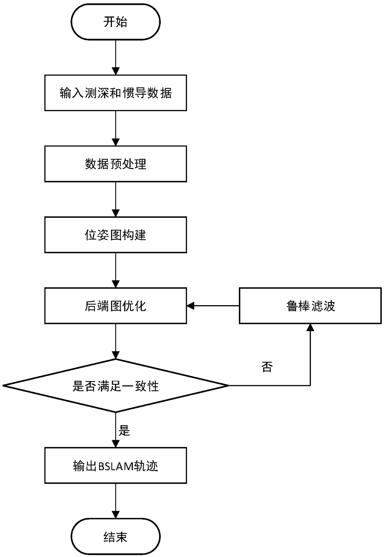
[0051] Such as figure 1 , a robust BSLAM method for AUV terrain matching navigation, including the following steps:

[0052] Step (1): Input bathymetry and inertial navigation data: When the AUV sails on the seabed for a long time and the inertial navigation data drifts too much, initialize the BSLAM, start the multi-beam sonar, collect the bathymetry and inertial navigation data of the seabed topography, and Continuous input into the BSLAM program;

[0053] Step (2): Data preprocessing: using the single ping filtering method of multi-beam bathymetric data based on the Alpha-Shapes model, the outliers in the multi-beam sonar bathymetric data are effectively eliminated, and the filtered bathymetric data are obtained ;

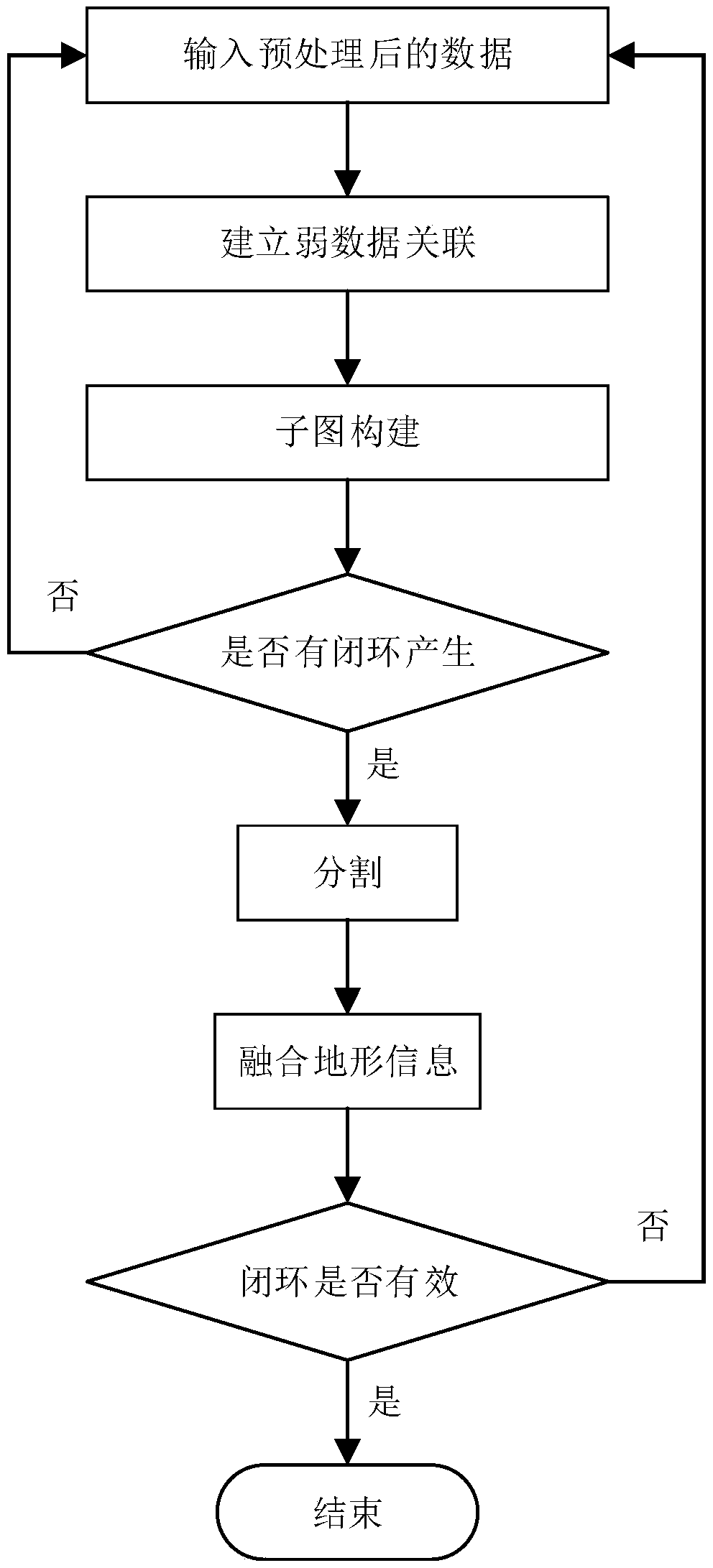
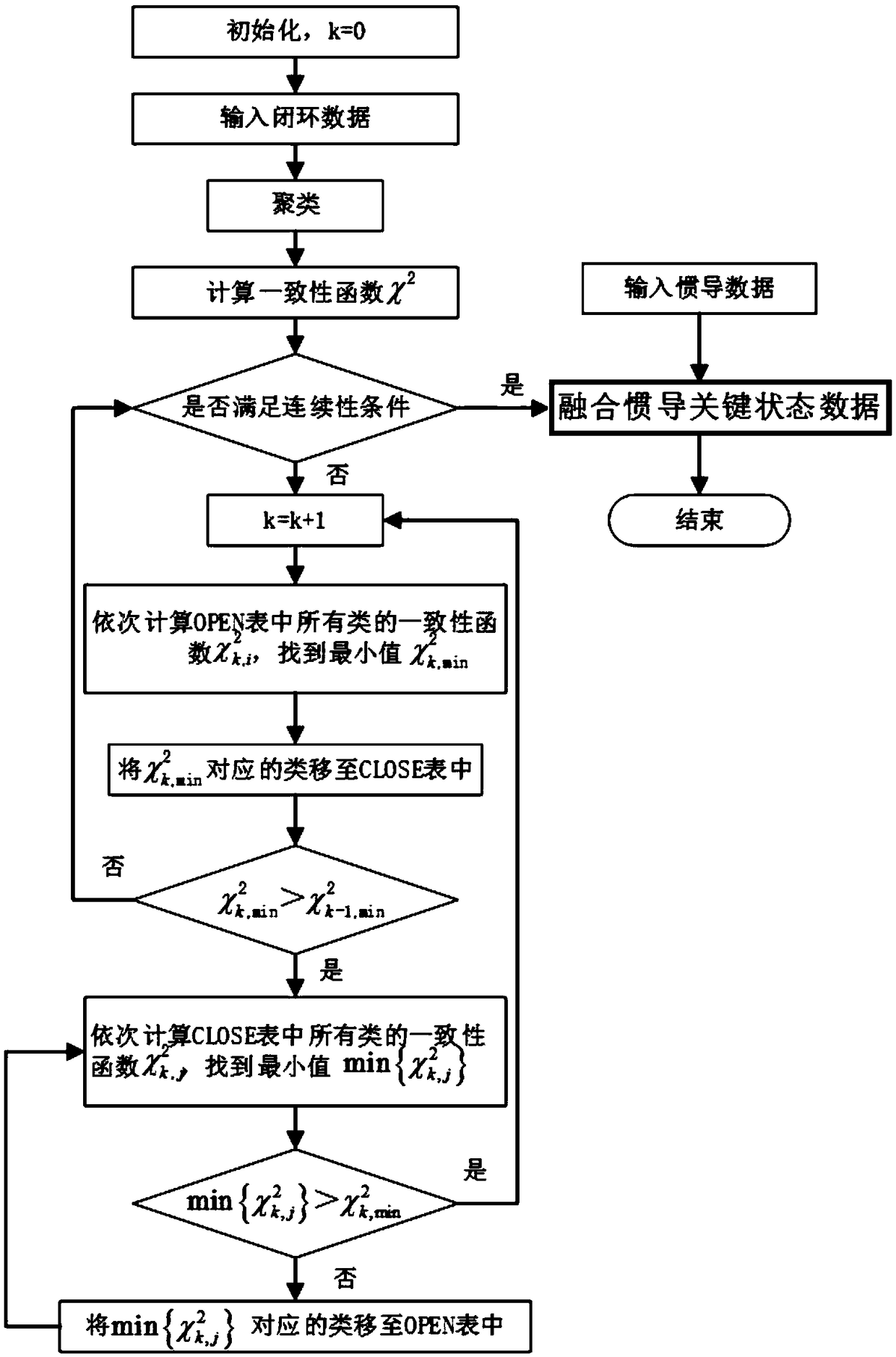
[0054] Step (3): If figure 2 , Pose graph construction: Gaussian process regression is used to estimate terrain depth and form weak data association; after the b...


PUM


Abstract

The invention belongs to the field of an underwater vehicle and discloses a robust BSLAM method for AUV terrain matching navigation. The method comprises the steps of (1), inputting depth sounding andinertia navigation data; (2), carrying out data preprocessing to obtain filtered depth sounding data; (3), establishing an attitude graph, specifically, computing weak data association, establishinga new subgraph, carrying out closed loop detection through terrain positioning, and then carrying out invalid closed loop detection; and (4), optimizing a rear end graph, specifically, computing consistency functions through utilization of clustered closed loop data, finding out the minimum values of the consistency functions in all classes, integrating data of key statuses of inertia navigation,and outputting a modified BSLAM track. According to the method, through processing and closed loop detection of the depth sounding and inertia navigation data, global optimization of the data is realized, timeliness and consistency of positioning and graph establishment are improved, robustness is high, and influence of noises of measurement data on navigation precision can be reduced.

Description

technical field [0001] The invention belongs to the field of underwater vehicles, in particular to a robust BSLAM method for AUV terrain matching navigation. Background technique [0002] Underwater robots are mainly divided into two categories: one is a cable underwater robot, which is commonly called a remote control submersible, or ROV for short; AUVs. Autonomous underwater robots integrate mission controllers of artificial intelligence and other advanced computing technologies, integrating deep submersibles, sensors, environmental effects, computer software, energy storage, conversion and propulsion, new materials and new processes, and underwater intelligence Weapons and other high-tech are used in the fields of anti-submarine warfare, mine warfare, reconnaissance and surveillance, and logistical support in the military. . For example, in the civilian field, it can be used for laying pipelines, seabed investigation, data collection, drilling support, seabed construct...

Claims


Application Information

Patent Timeline
IPC IPC(8): G01C21/20G01C21/16
CPCG01C21/165G01C21/203
Inventor 李晔徐硕马腾丛正贡雨森王汝鹏武皓微
Owner HARBIN ENG UNIV
Why Eureka
Try Eureka