Method for quickly modeling urban three-dimensional buildings for traffic environmental pollution simulation

A modeling method, building technology, applied in the field of road traffic and environment

Active Publication Date: 2019-01-11
SUN YAT SEN UNIV
View PDF7 Cites 10 Cited by
  • Summary
  • Abstract
  • Description
  • Claims
  • Application Information

AI Technical Summary

Problems solved by technology

[0005] The purpose of the present invention is to overcome the above-mentioned shortcoming of prior art, provide a kind of urban three-dimensional building rapid modeling method that faces traffic environment pollution simulation, this method solves the problem of rapidly generating building geometry model in real urban scene air pollution diffusion simulation process problems, improve the efficiency and accuracy of urban 3D building modeling, and simplify the pre-processing process of urban air pollution diffusion simulation

Method used


Image

  • Method for quickly modeling urban three-dimensional buildings for traffic environmental pollution simulation
  • Method for quickly modeling urban three-dimensional buildings for traffic environmental pollution simulation
  • Method for quickly modeling urban three-dimensional buildings for traffic environmental pollution simulation

Examples


Embodiment 1

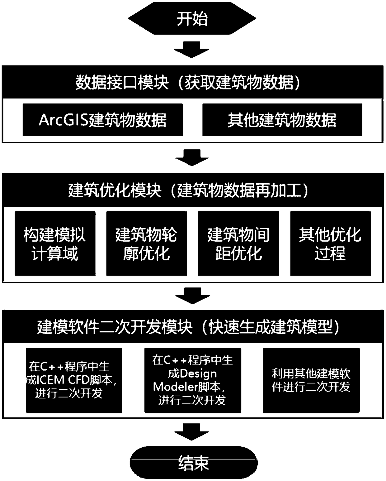
[0048] A rapid modeling method for urban 3D buildings oriented to traffic environment pollution simulation mainly includes the following steps:

[0049] (1) Based on the ArcGIS electronic map, export the building data of the CFD simulation area, specifically:

[0050] (11) Determine the scope of the simulation area (blocks near Renmin South Road, Guangzhou City). The longitude and latitude coordinates of the boundary coordinate points can be seen in Table 1, and the approximate range is 1.5km×1.3km. Use the projection tool in the ArcToolBox of the ArcGIS electronic map to convert the latitude and longitude coordinates of the shp format file into plane coordinates, and export the geometric data of the building to an excel file.

[0051] Table 1 Simulation area range

[0052] Coordinate points

longitude

latitude

A

113.2404

23.1088

B

113.2537

23.1088

C

113.2404

23.1200

D

113.2537

23.1200

[0053] ...


PUM


Abstract

A method for quickly modeling three-dimensional urban buildings for traffic environmental pollution simulation is characterized in that the specific steps are as follows: step 1, building data of a simulation area are derived through a digital urban software; 2, reading the building data through program language software and optimizing the building shape data characteristics, so that the buildingshape data can be obtain with better quality on the premise of ensuring the main shape characteristics of the building; 3, according to the building shape data and the boundary condition of the computational fluid dynamics simulation, designing a computational area of the numerical simulation; 4, generating a corresponding building through a modeling software script language, and calculating a modeling script of that domain. The method has the advantages of solving the problem of rapidly generating a building geometric model in the process of simulating the atmospheric pollution diffusion in areal urban scene, improving the efficiency and accuracy of the urban three-dimensional building modeling, and simplifying the pretreatment process of the urban atmospheric pollution diffusion simulation.

Description

technical field [0001] The invention relates to the field of road traffic and the environment, in particular to a rapid modeling method for urban three-dimensional buildings oriented to traffic environment pollution simulation. Background technique [0002] The problem of motor vehicle exhaust pollution in my country's cities has become increasingly prominent, seriously affecting urban air quality. With the effective development of pollution control from industrial sources and domestic sources, motor vehicles will become an important governance object for cities to complete air quality assessments and improve the living environment. The traffic emissions generated inside urban streets are affected by factors such as urban building layout and traffic flow changes, and it is easy to form high-concentration pollution on the roadside, and there are many exposed people for a long time, which directly endangers people's health. Therefore, accurate assessment of traffic emission p...

Claims


Application Information

Patent Timeline
Patent Type & Authority Applications(China)
IPC IPC(8): G06T17/00
CPCG06T17/00
Inventor 陈进财刘永红罗银萍
Owner SUN YAT SEN UNIV
Why Eureka
Try Eureka