Evaluation method, device, equipment and storage medium of laser radar positioning effect

A lidar, point cloud technology, applied in radio wave measurement systems, instruments, etc., can solve the problems of high cost, long cycle, difficult data distribution control, etc., to achieve the effect of improving efficiency and accuracy

Active Publication Date: 2019-03-12
BAIDU ONLINE NETWORK TECH (BEIJIBG) CO LTD
View PDF24 Cites 27 Cited by
  • Summary
  • Abstract
  • Description
  • Claims
  • Application Information

AI Technical Summary

Problems solved by technology

[0004] Among them, the point cloud data required for positioning mainly comes from the accumulated data of drive tests. This method is costly and long-term, and the data distribution is difficult to control. It is difficult to collect corresponding data for some rare scenes. Effectively evaluate the positioning effect in various environments and scenarios

Method used


Image

  • Evaluation method, device, equipment and storage medium of laser radar positioning effect
  • Evaluation method, device, equipment and storage medium of laser radar positioning effect
  • Evaluation method, device, equipment and storage medium of laser radar positioning effect

Examples


Embodiment 1

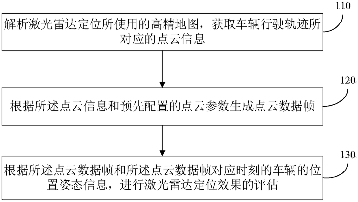
[0029] figure 1 It is a schematic flow chart of a LiDAR positioning effect evaluation method provided in Embodiment 1 of the present invention. The LiDAR positioning effect evaluation method provided in this embodiment is applicable to evaluating the LiDAR positioning effect of unmanned vehicles, especially for Evaluate the localization effect of LiDAR in various extreme environments and rare scenes for unmanned vehicles. For example, the extreme environment may be: extreme weather, including: foggy weather, rainstorm, snowstorm, windy weather, or sandy weather, etc.; the rare scene may be, for example, a scene of fallen leaves on the ground or a scene of different traffic flows. The LiDAR positioning effect evaluation method can be executed by a LiDAR positioning effect evaluation device. The device can be implemented by software and / or hardware, and is generally integrated into a terminal, such as a server. For details, see figure 1 As shown, the method includes the follow...

Embodiment 2

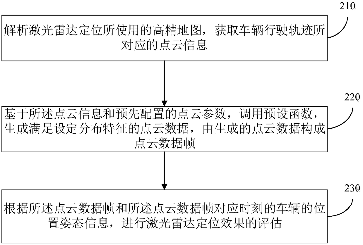
[0043] figure 2 It is a flow diagram of a laser radar positioning effect evaluation method provided by Embodiment 2 of the present invention. On the basis of the above embodiments, this embodiment specifies the point cloud information corresponding to the vehicle trajectory, and at the same time The realization process of "step 120, generating a point cloud data frame according to the point cloud information and pre-configured point cloud parameters" is described. For details, see figure 2 As shown, the method includes the following steps:

[0044] Step 210, analyzing the high-precision map used for the lidar positioning, and obtaining the point cloud information corresponding to the vehicle trajectory.

[0045] Specifically, the point cloud information may include three-dimensional coordinate values ​​of the point cloud, point cloud intensity values, and color information. The point cloud intensity value refers to the reflection intensity information of the laser, specifi...

Embodiment 3

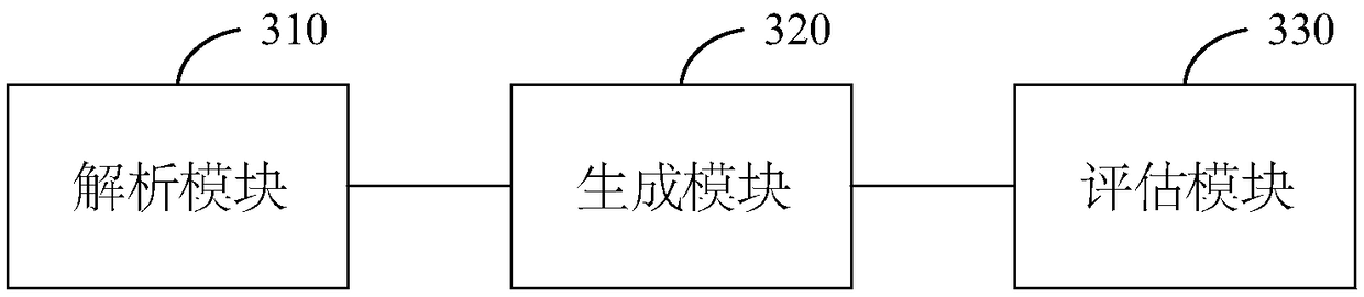
[0053] image 3 It is a schematic structural diagram of a laser point cloud positioning effect evaluation device provided in Embodiment 3 of the present invention, and the device is used to implement the laser radar positioning effect evaluation method described in the above embodiment. For details, see image 3 As shown, the device includes: an analysis module 310, a generation module 320 and an evaluation module 330;

[0054] Wherein, the parsing module 310 is used for parsing the high-precision map used for lidar positioning, and obtaining the point cloud information corresponding to the vehicle trajectory;

[0055] A generating module 320, configured to generate a point cloud data frame according to the point cloud information and preconfigured point cloud parameters;

[0056] The evaluation module 330 is configured to evaluate the laser radar positioning effect according to the point cloud data frame and the position and posture information of the vehicle at the corresp...


PUM


Abstract

The invention discloses an evaluation method, device, equipment and storage medium of laser radar positioning effect. The method comprises the steps that a high-precision map used by laser radar positioning is analyzed to obtain dot cloud information corresponding to a vehicle driving track; dot cloud data frames are generated according to the dot cloud information and dot cloud parameters which are configured in advance; the evaluation of the laser radar positioning effect is conducted according to the dot cloud data frame and the location attitude information of the vehicle at correspondingtimings of the dot cloud data frames. By means of the method, the simulation of the dot cloud data under various environments and scenarios is achieved to improve the whole positioning evaluation efficiency and accuracy, and a convenient and effective testing and debugging method is provided for the improvement of the positioning precision and robustness of the laser radar.

Description

technical field [0001] Embodiments of the present invention relate to automatic driving technology, and in particular to a method, device, device, and storage medium for evaluating a laser radar positioning effect. Background technique [0002] Self-driving cars, also known as unmanned cars, rely on technologies such as artificial intelligence, computer vision, radar, global positioning system and high-precision maps to automatically obtain environmental information around the vehicle and make decisions and path planning, so as to achieve complete independence Human-operated autonomous driving. LiDAR positioning is one of the mainstream positioning solutions for autonomous driving systems, and it is of great significance to evaluate its positioning effects in various environments and scenarios. [0003] At present, the evaluation process of lidar positioning effect is generally as follows: first collect the point cloud data required for positioning, then input the point clo...

Claims


Application Information

Patent Timeline
Patent Type & Authority Applications(China)
IPC IPC(8): G01S7/40
CPCG01S7/40
Inventor 李世伟
Owner BAIDU ONLINE NETWORK TECH (BEIJIBG) CO LTD
Why Eureka
Try Eureka