Supercharge Your Innovation With Domain-Expert AI Agents!

Geophysical survey system and method

A technology of geophysics and survey systems, applied in geophysical measurement, instruments, etc., can solve the problems of algorithm dependence threshold, interference of seismic wave detector, low operation efficiency, etc., achieve strong nonlinear fitting and approximation ability, improve accuracy, The effect of high computing efficiency

Pending Publication Date: 2019-03-19
GUILIN UNIVERSITY OF TECHNOLOGY +1
View PDF0 Cites 5 Cited by
  • Summary
  • Abstract
  • Description
  • Claims
  • Application Information

AI Technical Summary

Problems solved by technology

[0004] The existing geophysical survey data is inaccurate; at the same time, the existing geophysical model is of low quality and low computational efficiency
[0005] In the existing technology, while filtering out the relatively large proportion of low-frequency components, it is impossible to retain the mid-high frequency components with rich image details. At the same time, there is a problem that the algorithm used is too dependent on the threshold; the existing technology is not conducive to the correct acquisition of earth gravity data, there is The impact of dynamic errors on the detection data; the existing technology is not conducive to real-time monitoring of the earth's seismic wave signal data, and the external environment interferes seriously with the seismic wave detector, reducing the sensitivity of the seismic wave detector to detect seismic signals

Method used


Image

  • Geophysical survey system and method
  • Geophysical survey system and method
  • Geophysical survey system and method

Examples


Embodiment Construction

[0047] In order to further understand the content, features and effects of the present invention, the following examples are given, and detailed descriptions are given below with reference to the accompanying drawings.

[0048] The structure of the present invention will be described in detail below in conjunction with the accompanying drawings.

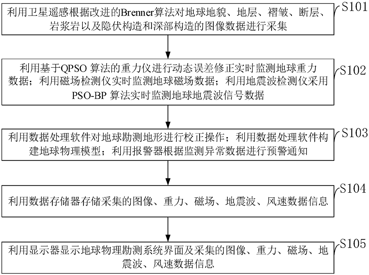
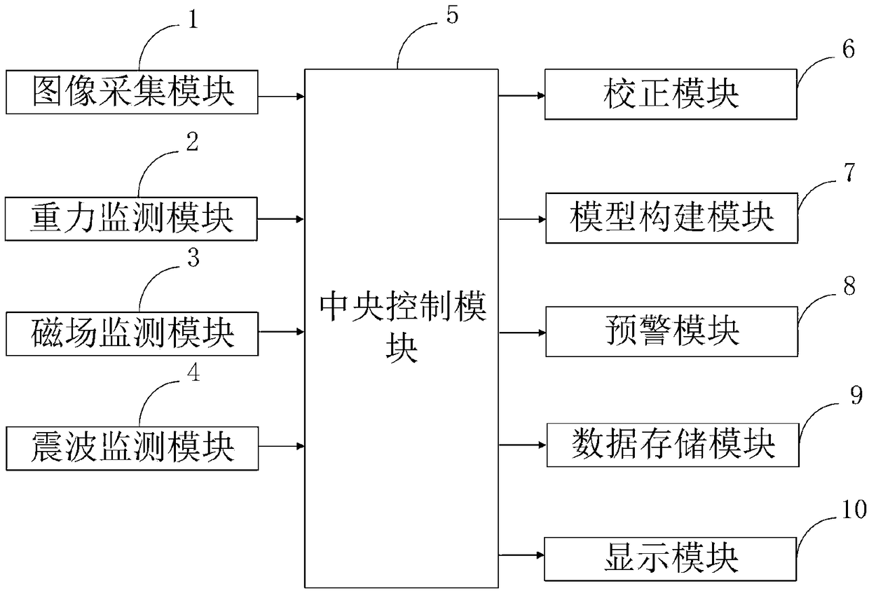
[0049] Such as figure 1 As shown, the geophysical surveying method that the embodiment of the present invention provides comprises the following steps:

[0050] S101: Use satellite remote sensing to collect image data of the earth's landforms, strata, folds, faults, magmatic rocks, hidden structures and deep structures according to the improved Brenner algorithm;

[0051] S102: Use the gravimeter based on the QPSO algorithm to perform dynamic error correction to monitor the earth's gravity data in real time; use the magnetic field detector to monitor the earth's magnetic field data in real time; use the seismic wave detector to use th...


PUM


Abstract

The invention belongs to the technical field of geophysical survey, and discloses a geophysical survey system and method. The geophysical survey system includes an image acquisition module, a gravitymonitoring module, a magnetic field monitoring module, a seismic wave monitoring module, a central control module, a correction module, a model building module, an early warning module, a data storagemodule and a display module. The accuracy of survey is improved by correcting the data of a survey area through the correction module; at the same time, the accuracy of a geophysical model is improved through the model building module, and a high-quality geophysical model is built. The model operation efficiency is high. The artificial neural network is used for modeling without any prior assumptions. Meanwhile, the artificial neural network has strong non-linear simulation approximation ability and the excellent characteristics of incomplete tolerance and noise removal, surface electromagnetic observation is achieved, and a new technical means is provided for the exploration of underground, geological structures and mineral resources.

Description

technical field [0001] The invention belongs to the technical field of geophysical surveying, and in particular relates to a geophysical surveying system and method. Background technique [0002] Geophysical prospecting, referred to as geophysical prospecting, refers to the detection of geological conditions such as stratum lithology and geological structure by studying and observing changes in various geophysical fields. Due to the differences in density, elasticity, electrical conductivity, magnetism, radioactivity, and thermal conductivity of different rock formation media that make up the earth's crust, these differences will cause local changes in the corresponding geophysical fields. By measuring the distribution and variation characteristics of these physical fields, combined with known geological data for analysis and research, the purpose of inferring geological properties can be achieved. Geophysical exploration is based on the difference in physical properties of...

Claims


Application Information

Patent Timeline
IPC IPC(8): G01V11/00
CPCG01V11/00
Inventor 余芳芳熊彬魏中举汪劲草张斯孙汉武
Owner GUILIN UNIVERSITY OF TECHNOLOGY
Features
  • R&D
  • Intellectual Property
  • Life Sciences
  • Materials
  • Tech Scout
  • Unparalleled Data Quality
  • Higher Quality Content
  • 60% Fewer Hallucinations
Learn More