Check patentability & draft patents in minutes with Patsnap Eureka AI!

Unmanned aerial vehicle precise positioning landing system and method

A precise positioning and UAV technology, applied in the control/adjustment system, three-dimensional position/course control, vehicle position/route/altitude control, etc. Solve problems such as man-machine height information and difficulty in obtaining UAV position information to achieve low cost, accurate positioning, and small size

Inactive Publication Date: 2019-03-22
FUJIAN JIANGXIA UNIV
View PDF5 Cites 3 Cited by
  • Summary
  • Abstract
  • Description
  • Claims
  • Application Information

AI Technical Summary

Problems solved by technology

[0003] The use of existing drones usually uses remote control technology, using microwave communication, and remotely controls the drone for operations through the video screen of the camera. Since this technology requires manual real-time operation, it can conveniently control the speed and direction of the drone. And other parameters, the disadvantage is that once the communication network fails, such as hacker interception, climate or geographical environment, there will be an uncontrollable situation, and the situation at this time will bring a high risk of crashing or difficulty returning to the drone.
However, in the environment where Beidou navigation or GPS signals are weak, it will be difficult to obtain the location information of drones, and the accuracy of conventional satellite navigation is generally greater than 5 meters, which cannot guarantee the precise landing of micro drones. Importantly, satellite navigation technology cannot correctly distinguish the height information of the UAV from the ground, and similar position information will be obtained even if the height differs by tens of meters

Method used


Image

  • Unmanned aerial vehicle precise positioning landing system and method

Examples


Embodiment Construction

[0022] The present invention will be further described below in conjunction with the accompanying drawings and embodiments.

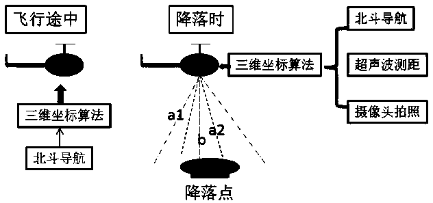
[0023] Please refer to figure 1 , the present invention provides a precise positioning and landing system for drones, including a three-dimensional coordinate algorithm module for judging the distance between the drone and the starting point and the target point; a Beidou navigation module for obtaining the starting point, the target point and the traveling process The latitude and longitude values ​​of the points are converted into the three-dimensional coordinate values ​​used by the cost system through an algorithm to assist in correcting the path; the ultrasonic ranging module is used to obtain the distance in the vertical direction and convert it into a value in the system coordinate system to assist in correcting the unmanned The position of the drone; the camera module, used to judge whether the drone is near the starting point or the target poin...


PUM

PropertyMeasurementUnit
Frequencyaaaaaaaaaa

Abstract

The invention relates to an unmanned aerial vehicle precise positioning landing system. The unmanned aerial vehicle precise positioning landing system comprises a three-dimensional coordinate algorithm module, a Beidou navigation module, an ultrasonic ranging module and a camera shooting module. The three-dimensional coordinate algorithm module is used for judging the distance between an unmannedaerial vehicle and a starting point and a target point. The Beidou navigation module is used for acquiring the longitude and latitude values of the starting point, the end point and an advancing process point and converting the longitude and latitude values into three-dimensional coordinate values adopted by the system through an algorithm, and path correction is assisted. The ultrasonic ranging module is used for acquiring the distance in the vertical direction and converting the distance in the vertical direction into numerical values in a coordinate system of the system, and unmanned aerialvehicle position correction is assisted. The camera shooting module is used for judging whether the unmanned aerial vehicle is near the starting point or the target point, and unmanned aerial vehiclesystem coordinate value correction is assisted. The three-dimensional coordinate algorithm module is connected with the Beidou navigation module, the ultrasonic ranging module and the camera shootingmodule. According to the unmanned aerial vehicle precise positioning landing system, the ultrasonic ranging module and the camera shooting module are combined to acquire unmanned aerial vehicle position information during landing, and precise positioning information can be obtained.

Description

technical field [0001] The invention relates to the field of unmanned aerial vehicles, in particular to a precise positioning and landing system and method for unmanned aerial vehicles. Background technique [0002] UAV has the advantages of small size, low cost, good mobility, and strong stealth ability, so it is widely used in national defense and military industry, express transportation, traffic safety, geological exploration and other fields. [0003] The use of existing drones usually uses remote control technology, using microwave communication, and remotely controls the drone for operations through the video screen of the camera. Since this technology requires manual real-time operation, it can conveniently control the speed and direction of the drone. And other parameters, the disadvantage is that once the communication network fails, such as hacker interception, climate or geographical environment, there will be an uncontrollable situation, and the situation at thi...

Claims


Application Information

Patent Timeline
IPC IPC(8): G05D1/10
CPCG05D1/101
Inventor 羊富贵任海科乔亮祝晓霞沈振辉夏忠朝
Owner FUJIAN JIANGXIA UNIV
Features
  • R&D
  • Intellectual Property
  • Life Sciences
  • Materials
  • Tech Scout
  • Unparalleled Data Quality
  • Higher Quality Content
  • 60% Fewer Hallucinations
Learn More