Slope surface water and soil loss quantity measuring instrument and use method thereof

A technology of volume measurement and slope surface, which is applied in the field of soil and water conservation monitoring, can solve the problems affecting the accuracy of monitoring, manual measurement, uncertainty factors of recording errors, etc., and achieve the effect of reducing errors, easy operation and portability

Active Publication Date: 2019-03-26
安徽省(水利部淮河水利委员会)水利科学研究院(安徽省水利工程质量检测中心站)
View PDF11 Cites 2 Cited by
  • Summary
  • Abstract
  • Description
  • Claims
  • Application Information

AI Technical Summary

Problems solved by technology

This method requires surveyors to arrive at the site regularly for monitoring, and at the same time, they need to carry a large number of instruments and equipme

Method used


Image

  • Slope surface water and soil loss quantity measuring instrument and use method thereof
  • Slope surface water and soil loss quantity measuring instrument and use method thereof
  • Slope surface water and soil loss quantity measuring instrument and use method thereof

Examples


Embodiment 1

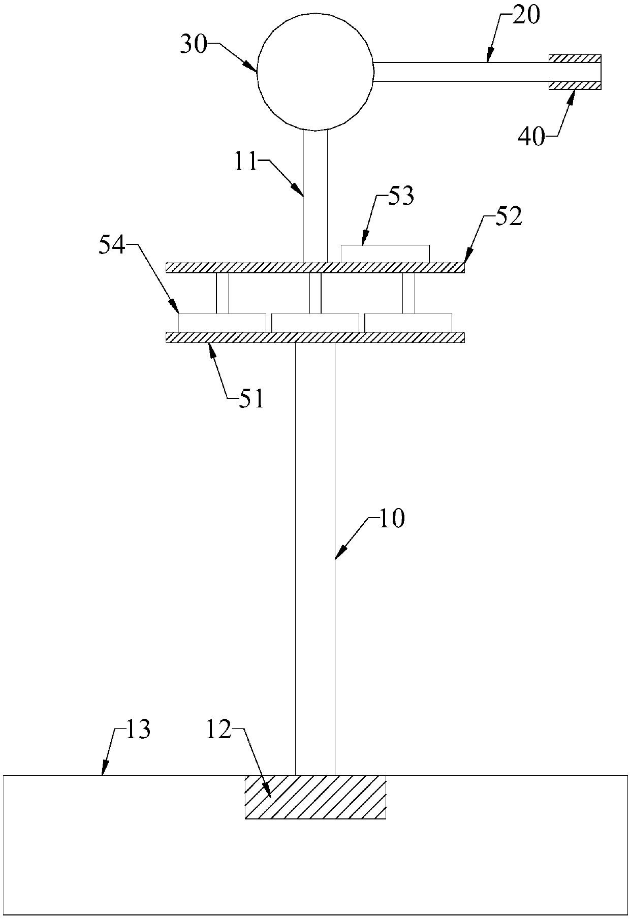
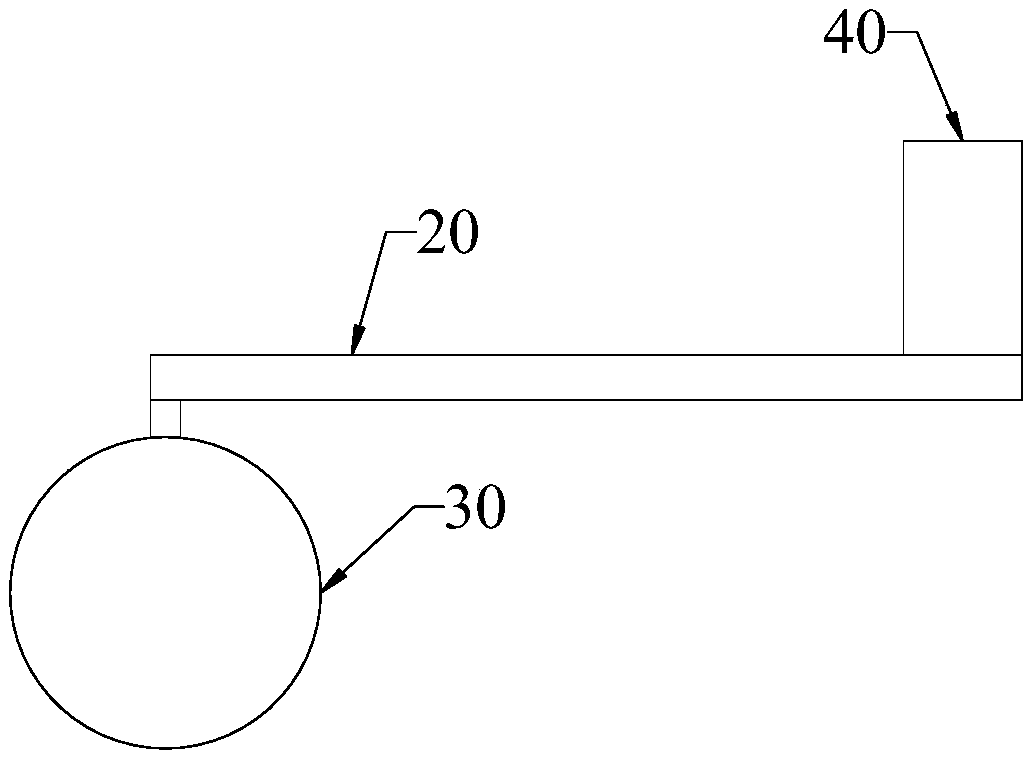
[0026] Such as figure 1 , 2 As shown, the measuring instrument for soil and water loss on the slope comprises a lower frame pole 10, an upper frame pole 11, a positioning rod 20, a positioning ball 30 fixed on the upper end of the upper frame pole 11, a laser range finder 40, and a The horizontal adjustment structure between the vertical rod 10 and the upper rack vertical rod 11, the head end of the positioning rod 20 is rotationally connected with the positioning ball 30, and the laser range finder 40 is vertically installed at the tail end of the positioning rod 20; the positioning The plane where the rotation track of the rod 20 is located is perpendicular to the ranging direction of the laser range finder 40 . The slope surface water and soil loss measurement instrument also includes a data transmission module and a data storage module. The laser rangefinder 40 collects measurement distance data, and transmits relevant data to the data storage module through the data tran...

Embodiment 2

[0034] The telescopic rod is one of an electric push rod and a linear motor. Both electric actuators or linear motors are capable of reciprocating linear motion, which can be used as telescoping rods. The telescopic rod is extended or shortened so that the slope surface soil and water loss measuring instrument can be applied to the measurement of various types of slopes, and the application range and degree of application of the slope surface soil and water loss measuring instrument are improved.

Embodiment 3

[0036] During the measurement operation, in order to avoid the deviation of the laser range finder 40 . The positioning ball 30 is equipped with a locking device. After adjusting the position of the laser range finder 40, use the locking device to lock the head end of the positioning rod 20 and the positioning ball 30, so as to avoid the deviation of the laser range finder 40 during the measurement operation and ensure the accuracy of the measurement. The precision of the result.

[0037] Wherein, the locking device can be designed as a locking bolt, and the locking bolt locks the head end of the positioning rod 20 and the positioning ball 30 through a threaded connection.

[0038] In the above embodiment, compared with the prior art, the slope surface soil erosion measurement instrument has the following advantages:

[0039] 1) Laser ranging can be used for long-distance measurement and can adapt to the monitoring of different slope types.

[0040] 2), the instrument of th...


PUM


Abstract

The invention relates to a slope surface water and soil loss quantity measuring instrument and a use method thereof. The slope surface water and soil loss quantity measuring instrument comprises a lower frame vertical rod, an upper frame vertical rod, positioning rods, a positioning ball, a laser distance measuring device and a horizontal regulating structure, wherein the positioning ball is fixedly arranged on the upper end of the upper frame vertical rod; the horizontal regulating structure is arranged between the lower frame vertical rod and the upper frame vertical rod; the head end of thepositioning rod is rotationally connected with the positioning ball; the laser distance measuring device is vertically arranged between the tail ends of the positioning rod; the located plane of therotation track of the positioning rod is vertical to the distance measuring direction of the laser distance measuring device. The laser distance measuring technology is applied to the water soil maintaining monitoring work. Firstly, the early stage data of the monitoring slope is collected; the regularly collected slope surface data is calculated in a comparison way; indexes such as slope surfacewater and soil loss quantity can be monitored.

Description

technical field [0001] The invention relates to a measuring instrument for water and soil loss on a slope surface and a using method thereof, belonging to the technical field of water and soil conservation monitoring. Background technique [0002] The traditional monitoring of water and soil conservation in development and construction projects is to manually bring the various instruments required for monitoring to the monitoring point, each instrument works independently, and records the monitoring results. This method requires surveyors to arrive at the site regularly for monitoring, and at the same time, they need to carry a large number of instruments and equipment each time. Moreover, there are large errors and many uncertain factors in manual measurement and recording, which seriously affect the accuracy of monitoring. Contents of the invention [0003] Aiming at the deficiencies in the prior art, the present invention provides a measuring instrument for soil and wat...

Claims


Application Information

Patent Timeline
IPC IPC(8): G01N33/24
CPCG01N33/24
Inventor 夏小林朱昊宇张晓东赵黎明张卫汪邦稳刘旦旦张靖雨
Owner 安徽省(水利部淮河水利委员会)水利科学研究院(安徽省水利工程质量检测中心站)
Why Eureka
Try Eureka