
A new mobile map application service system based on GeoPDF technology

A map application and service system technology, applied in the computer field, can solve problems such as easy loss, large data volume of sliced ​​maps, scattered data storage, etc., and achieve the effect of small data volume and convenient outdoor work

Active Publication Date: 2019-03-29
云南省地图院
View PDF10 Cites 2 Cited by
  • Summary
  • Abstract
  • Description
  • Claims
  • Application Information

AI Technical Summary

Problems solved by technology

This technology has several deficiencies. First, the sliced ​​map data volume is too large. Second, the sliced ​​map requires professional GIS software to open it. Third, the data is scattered and easily lost. Fourth, the overall sense of the administrative area is weak.

Method used


Image

  • A new mobile map application service system based on GeoPDF technology

Examples


Embodiment 1

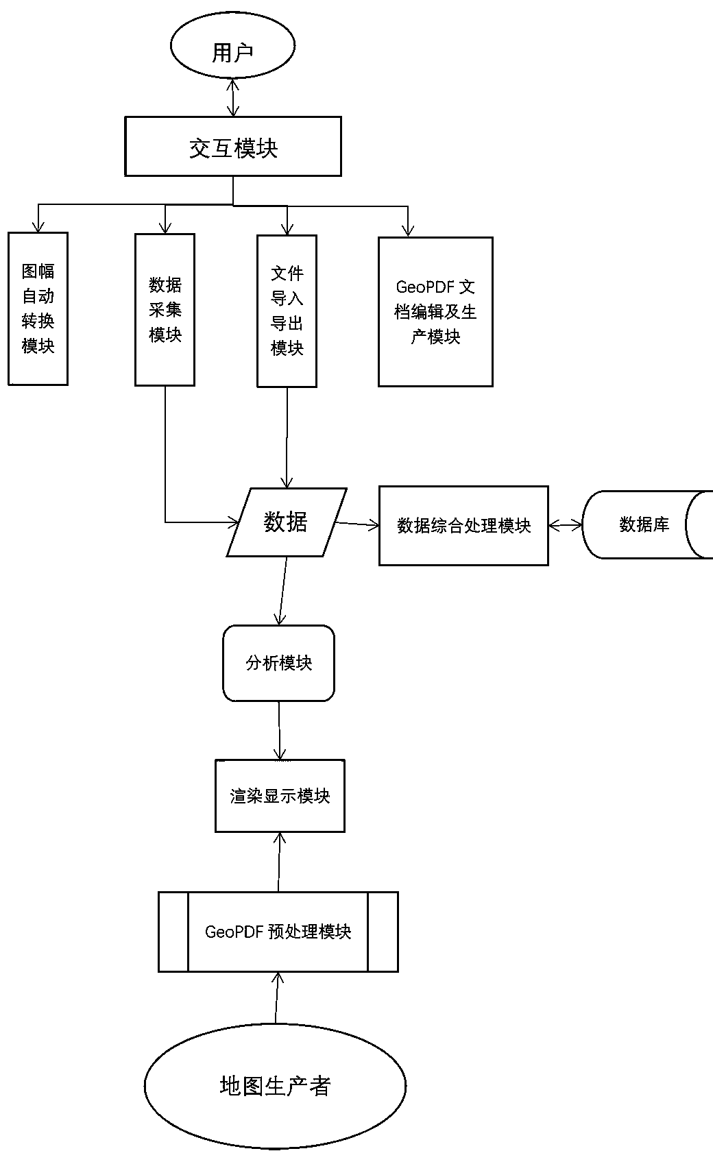
[0024] Embodiment 1: a novel mobile map application service system based on GeoPDF technology, including the following modules:

[0025] The GeoPDF preprocessing module imports the GeoPDF format map provided by the electronic map supplier into the system to obtain the geographic information in GeoPDF; and imports the GeoPDF format map coordinates and PDF document coordinate system in the system, as well as the mobile device coordinate system, through Coordinate drift correction, coordinate area stretching, establish the mapping relationship of the three coordinate systems, one-to-one correspondence; and establish the spatial index of each map according to the administrative division level of each map and the coordinate information of the rectangular frame outside the map;

[0026] Among them, when forming the coordinate mapping relationship, coordinate deviation correction, precise positioning and area stretching algorithms are used to realize map data collection and map interf...


PUM


Abstract

A new mobile map application service system based on GeoPDF technology relates to computer technology, especially a new mobile electronic map application system. The system comprises a GeoPDF preprocessing module, a rendering display module, an analysis module and a data comprehensive processing module. The system of the present invention enables each point on the pdf map to correspond to a specific geographic position in reality after the relationship between the coordinate systems is established for each position on the pdf map which originally has no specific meaning.

Description

technical field [0001] The invention relates to computer technology, in particular to a novel mobile electronic map application system. Background technique [0002] Since its birth and development, the map has become an indispensable and important tool for people to know, understand and use the geographical environment, and is widely used in various industries such as economy, society, culture and military. In the information age, with the transition from analog maps to digital maps, various special map products based on digital maps and information systems that can provide various map services are emerging, which are collectively referred to as new maps, such as multimedia electronic maps. (set), positioning navigation system and information query system, etc. Its ease of use has greatly expanded the application of maps, resulting in a large number of users, such as digital earth and smart cities, and has transformed the "map" users originally aimed at professionals into ...

Claims


Application Information

Patent Timeline
Patent Type & Authority Applications(China)
IPC IPC(8): G06F16/29
CPCY02D10/00
Inventor 肖提荣李正洋何照攀杨勇刘祝明林根张凤杨袁聪刘康符钟壬
Owner 云南省地图院
Learn More