Method for measuring mining subsidence crack of mining area through low-altitude unmanned aerial vehicle photography

A technology of collapse cracks and drones, which can be used in the interpretation of photos and other directions, which can solve the problems of long acquisition time and complex process.

Active Publication Date: 2019-04-16
XIAN UNIV OF SCI & TECH
View PDF4 Cites 6 Cited by
  • Summary
  • Abstract
  • Description
  • Claims
  • Application Information

AI Technical Summary

Problems solved by technology

However, UAV terrain surveying and mapping requires 3D modeling of UAV images in the

Method used


Image

  • Method for measuring mining subsidence crack of mining area through low-altitude unmanned aerial vehicle photography
  • Method for measuring mining subsidence crack of mining area through low-altitude unmanned aerial vehicle photography
  • Method for measuring mining subsidence crack of mining area through low-altitude unmanned aerial vehicle photography

Examples


Embodiment Construction

[0064] Such as Figure 1 to Figure 4 A kind of low-altitude unmanned aerial vehicle photogrammetric method for coal mining subsidence fracture shown in the mining area comprises the following steps:

[0065] Step 1. Acquisition of shooting parameters and layout of rule boards:

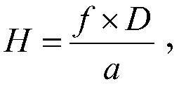
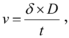
[0066] Step 101, carry the digital camera 4 on the drone 3, according to the formula Get the aerial height of UAV 3, according to the formula Obtain the aerial photography speed of unmanned aerial vehicle 3; Wherein, the image size that digital camera 4 shoots is A * B pixel point, and A represents row, and B represents column, and f represents the focal length of digital camera 4, and D represents ground resolution; The size of the unit pixel on the row direction; δ represents image point displacement, and the unit is pixel, and t represents the exposure time of digital camera 4, and the unit is second;

[0067] Step 102: Along the length direction of the coal mining subsidence crack 2 in the min...


PUM


Abstract

The invention discloses a method for measuring a mining subsidence crack of a mining area through low-altitude unmanned aerial vehicle photography. The method comprises the following steps of 1, acquiring shooting parameters and arranging regular plates; 2, collecting and transmitting crack images; 3, establishing a coordinate system; 4, acquiring deformation coefficients of the crack images and acquiring object space coordinates; 5, acquiring conversion parameters of the object space coordinates to geographic coordinates; and 6, acquiring mining subsidence crack data of the mining area. The method has simple steps and reasonable design, the coordinate conversion parameters and the deformation coefficients are acquired through the regular plates, only and furthermore, an error of coordinate conversion accumulation is reduced, a processing process is simple, the accuracy of acquisition of the crack parameters is guaranteed, and the practicability is high.

Description

technical field [0001] The invention belongs to the technical field of measuring coal mining subsidence cracks in mining areas, and in particular relates to a method for measuring coal mining subsidence cracks in mining areas by photography of a low-altitude unmanned aerial vehicle. Background technique [0002] The landform and topography of coal mining subsidence areas in mining areas are complex, and it is difficult to implement conventional surveys. At the same time, the distribution of surface subsidence cracks caused by large-scale underground coal mining is complicated. At present, total stations are used for conventional surveys, but it is difficult to implement, and only mining The general distribution of coal subsidence cracks cannot obtain the mesoscopic and microscopic characteristics of coal mining subsidence cracks, and it is not convenient to draw actual cracks; with the development of measurement technology, photogrammetry can be used to establish an accurate ...

Claims


Application Information

Patent Timeline
IPC IPC(8): G01C11/06
CPCG01C11/06
Inventor 汤伏全黄景偲闫照存李林宽
Owner XIAN UNIV OF SCI & TECH
Why Eureka
Try Eureka