Imaging satellite autonomous task planning method based on machine learning

An autonomous task and machine learning technology, applied in machine learning, instruments, computing models, etc., can solve the problems of long planning time, low task execution efficiency, and inability to real-time planning in satellite ground centralized management and control mode. The effect of high execution efficiency and guaranteed robustness

Active Publication Date: 2019-05-17
NAT UNIV OF DEFENSE TECH
View PDF12 Cites 11 Cited by
  • Summary
  • Abstract
  • Description
  • Claims
  • Application Information

AI Technical Summary

Problems solved by technology

[0012] The technical problem to be solved by the present invention is to solve the problem that the existing satellite ground centralized management and control mode takes a long time to plan, the task execution efficiency is low, and it cannot be planned in real time according to environmental changes. A Machine Learning-Based Autonomous Mission Planning Method for Imaging Satellites to Improve the Efficiency of Satellite Mission Planning Through On-board Autonomous Planning

Method used


Image

  • Imaging satellite autonomous task planning method based on machine learning
  • Imaging satellite autonomous task planning method based on machine learning
  • Imaging satellite autonomous task planning method based on machine learning

Examples


Embodiment Construction

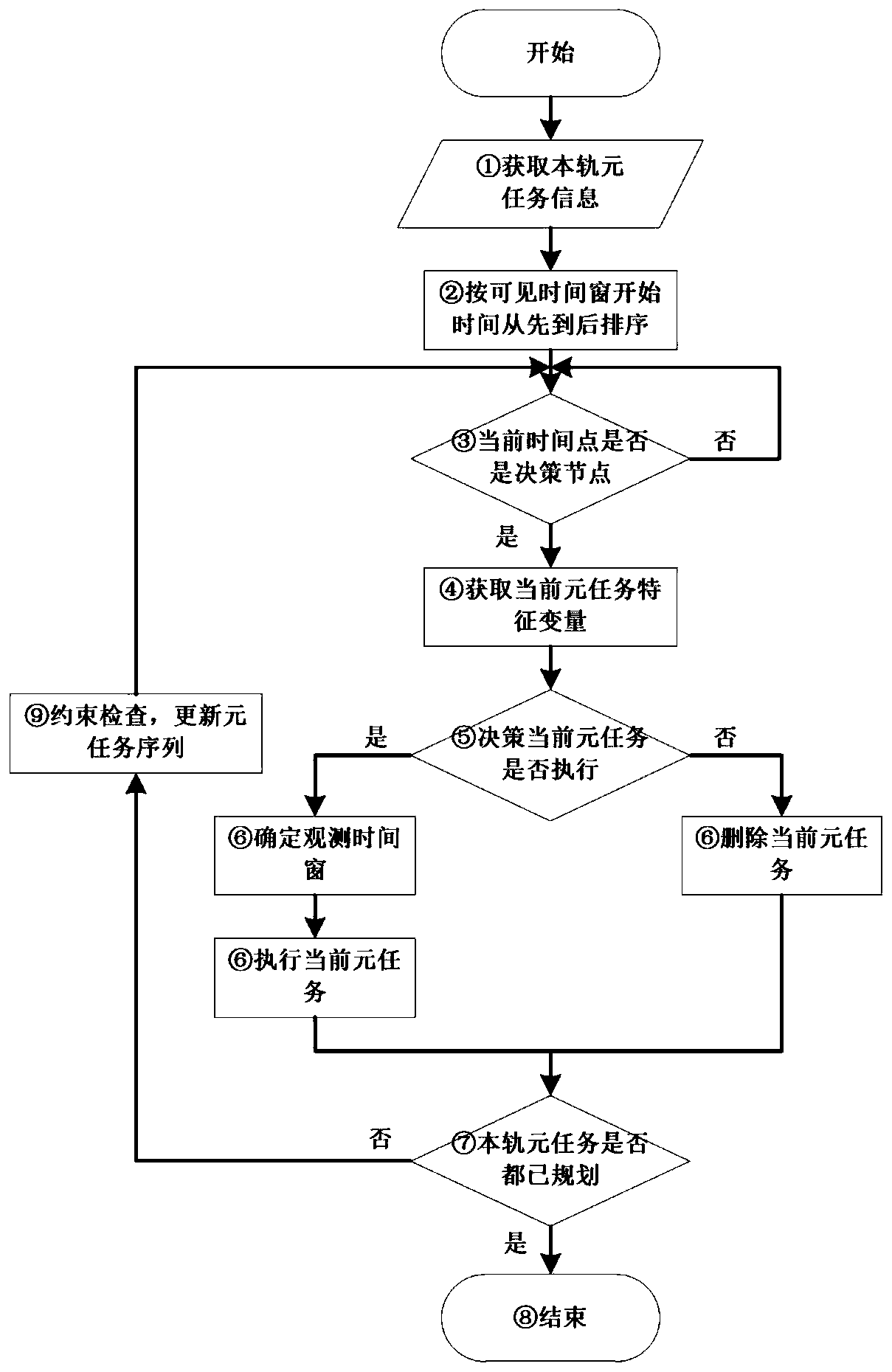
[0046] First of all, let’s clarify the concept. The meta-task referred to in the present invention refers to that since the satellite may be visible to the same target on multiple orbits, the completion of the observation of this target is called “task”, and each observation opportunity of this target is called “task”. It is called "meta task". For example, if a certain target is visible on the 3rd, 4th, and 9th orbits of the satellite, then each observation opportunity on the 3rd, 4th, and 9th orbits is called the "meta task" of this target, and one of them can be selected When any meta-task is executed, the observation of the target is completed. Each meta-task of the target has a one-to-one correspondence with its visible time window. To decide whether to execute a certain meta-task is to decide whether to arrange observations in its corresponding visible time window. Therefore, the autonomous mission planning problem for non-agile satellites can be expressed as solving th...


PUM


Abstract

The invention discloses an imaging satellite autonomous task planning method based on machine learning. The imaging satellite autonomous task planning method comprises the steps that 1, ranking orbitelement tasks according to the starting time of a visible time window; And 2, when the current time is the decision time point, setting the meta-task as the current meta-task. 3, extracting a characteristic variable of the current meta-task, judging whether to execute the current meta-task or not through an on-board autonomous task planning model based on machine learning, outputting an observation time window of the current meta-task if the current meta-task is judged to be executed, executing the current meta-task when the observation time window starts, and deleting the current meta-task ifthe current meta-task cannot be executed; And 4, judging whether the rail element task is planned or not, if yes, ending, and if not, returning to the step 2. The method has the advantages that compared with a traditional satellite task planning method, the planning time is short, the task execution efficiency is high, and planning can be conducted in real time according to environment changes.

Description

technical field [0001] The invention belongs to the field of satellite mission planning, and in particular relates to a method for autonomous mission planning of imaging satellites based on machine learning. Background technique [0002] The traditional satellite mission planning and control mode is based on centralized management and control on the ground. The entire satellite earth observation process is a closed-loop process from users submitting requirements to users getting products, such as figure 1 shown. ① The user first submits an imaging task request to the management and control department; ② The management and control department preprocesses the task in combination with meteorological information, and converts it into a standard task information format for mission planning; ④ The management and control department generates a load control plan and a tracking and receiving plan according to the task scheduling plan and sends it to the satellite measurement and con...

Claims


Application Information

Patent Timeline
Patent Type & Authority Applications(China)
IPC IPC(8): G06Q10/06G06N20/00
Inventor 王涛宋彦杰宋冰玉陈英武吕济民陈盈果陈成陈宇宁刘晓路邢立宁姚锋贺仁杰张忠山
Owner NAT UNIV OF DEFENSE TECH
Why Eureka
Try Eureka