Formation cooperation navigation method for unmanned aerial vehicle

A collaborative navigation and unmanned aerial vehicle technology, applied in the field of navigation, can solve problems such as unsatisfactory accuracy

Active Publication Date: 2019-05-28
NANJING UNIV OF AERONAUTICS & ASTRONAUTICS
View PDF8 Cites 23 Cited by
  • Summary
  • Abstract
  • Description
  • Claims
  • Application Information

AI Technical Summary

Problems solved by technology

However, the accuracy of existing multi-UAV collaborative navigation methods is not ideal.

Method used


Image

  • Formation cooperation navigation method for unmanned aerial vehicle
  • Formation cooperation navigation method for unmanned aerial vehicle
  • Formation cooperation navigation method for unmanned aerial vehicle

Examples


Embodiment Construction

[0095] The technical solutions of the present invention will be described in detail below in conjunction with the accompanying drawings.

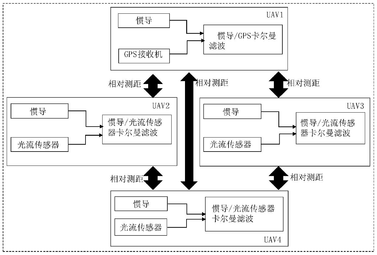
[0096] like figure 1 As shown, a UAV formation cooperative navigation method designed in the present invention, the UAV formation includes 4 UAV nodes: UAV nodes 1-4, including the following steps:

[0097] Step 1: Establish body coordinate system and navigation coordinate system;

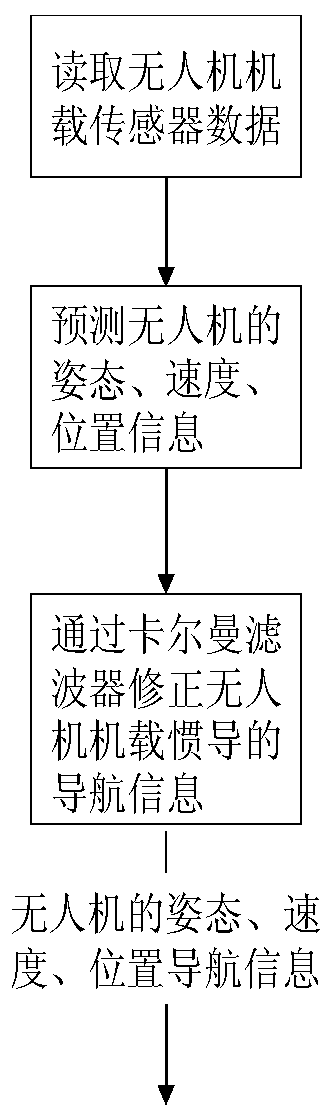
[0098] Step 2: Carry the inertial navigation system and GPS receiver on the UAV node 1, periodically read the airborne sensor information of the UAV node 1 at time k, including speed information, position information, gyroscope information and accelerometer information;

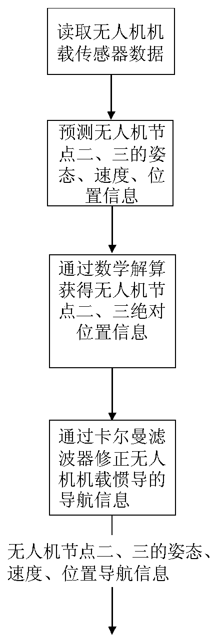
[0099]Step 3: Predict the attitude quaternion, speed and position information of UAV node i at time k, where i=1,2,3,4;

[0100] Step 4: Use the Kalman filter to correct the attitude quaternion, speed, and position information of the UAV node 1 at time k, and obtain the high-precision navigat...


PUM


Abstract

The invention discloses a formation cooperation navigation method for an unmanned aerial vehicle. During formation of the unmanned aerial vehicle, a lead aircraft unmanned aerial vehicle node is carried with an inertial navigation system and a GPS receiver, the posture, speed and position are estimated through airborne inertial navigation/GPS fusion filtering, and high-precision posture, speed andposition navigation information of the lead aircraft unmanned aerial vehicle node is obtained; other unmanned aerial vehicle nodes are carried with the inertial navigation system, a vision navigationdevice and a light stream sensor, through the vision navigation device, the relative distance of the unmanned aerial vehicle and a lead aircraft, a pitch angle and an azimuth angle are obtained, absolute position information of the adjacent lead aircraft unmanned aerial vehicle nodes is mathematically solved, speed information of the unmanned aerial vehicle is obtained through solution of the light stream sensor, and the airborne inertial navigation error is corrected through Kalamn filtering. In addition, the relative distance between the unmanned aerial vehicle node, further away from the lead aircraft, in formation and other unmanned aerial vehicle nodes is solved through the vision navigation device, and based on the relative distance, the absolute position information is solved.

Description

technical field [0001] The invention belongs to the technical field of navigation, and in particular relates to a navigation method for an unmanned aerial vehicle. Background technique [0002] The unmanned aerial vehicle system is a kind of unmanned aerial robot system that can be independently controlled or remotely controlled. It can perform combat tasks on the ground, sea, and air. It is recyclable, reusable, and efficient. With the diversity and complexity of mission requirements, the ability of a single UAV to perform missions is limited, and its survivability is greatly challenged. The collaboration between multiple drones can realize information sharing and action coordination, realize the task expansion of a single drone, and improve the success rate of task execution. The navigation system provides the navigation information necessary for the flight control system of the UAV, which is the necessary guarantee for it to complete various complex flight tasks. [000...

Claims


Application Information

Patent Timeline
Patent Type & Authority Applications(China)
IPC IPC(8): G01C21/16G01C21/20G05D1/10
Inventor 朱徐东赖际舟吕品周子寒何容
Owner NANJING UNIV OF AERONAUTICS & ASTRONAUTICS
Why Eureka
Try Eureka