A forest single tree parameter extraction method

A parameter extraction and forest technology, applied in the fields of instruments, character and pattern recognition, computer parts, etc., can solve the problems of slow speed, difficult to popularize and use, lack of solutions for large data volume, etc., to achieve the effect of improving speed and accuracy

Active Publication Date: 2019-06-18
INST OF BOTANY CHINESE ACAD OF SCI
View PDF8 Cites 2 Cited by
  • Summary
  • Abstract
  • Description
  • Claims
  • Application Information

AI Technical Summary

Problems solved by technology

However, the segmentation method based on 3D point cloud data requires a lot of operations and calculations, and the speed

Method used


Image

  • A forest single tree parameter extraction method
  • A forest single tree parameter extraction method
  • A forest single tree parameter extraction method

Examples


Example Embodiment

[0016] The present invention will be described in detail below in conjunction with the drawings. However, it should be understood that the drawings are only provided for a better understanding of the present invention, and they should not be construed as limiting the present invention.
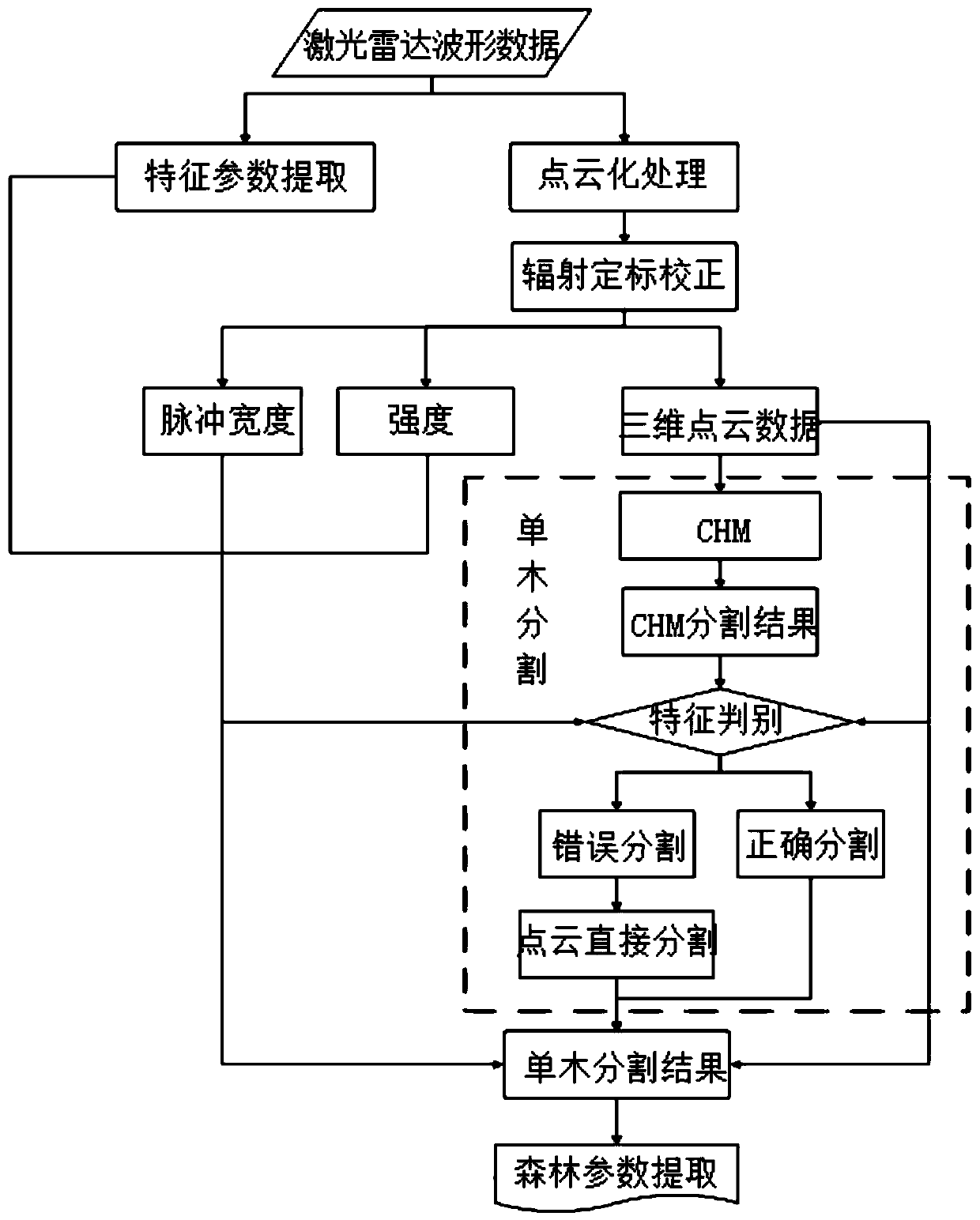
[0017] Such as figure 1 As shown, the method for extracting forest single tree parameters provided by the present invention includes the following steps:

[0018] 1) Extract the characteristic parameters of the lidar waveform data of the forest, where the characteristic parameters of the lidar waveform data include the leading edge, the trailing edge and the half energy height of the lidar waveform data.

[0019] The lidar waveform data is based on the time difference between the laser pulse recorded by the lidar scanner from launch to return to the receiver, and the distance between the measured object and the lidar scanner is obtained, combined with GPS (Global Positioning System) and IMU (Inertia...


PUM


Abstract

The invention relates to a forest single-tree parameter extraction method. The method is characterized by comprising the following steps: 1) extracting characteristic parameters of laser radar waveform data of a forest; 2) obtaining pulse width and intensity of the three-dimensional point cloud data of the forest and the laser radar waveform data after Gaussian decomposition; 3) obtaining three-dimensional point cloud data of the forest after radiation calibration correction and pulse width and intensity of laser radar waveform data after radiation calibration correction; 4) performing single-tree segmentation on the forest to obtain a single-tree segmentation result of the forest; And 5) according to the characteristic parameters of the laser radar waveform data, the 3D point cloud data of the forest after radiometric calibration, and the pulse width and intensity of the laser radar waveform data after radiometric calibration, extracting the parameters of the single wood segmentationresult, and Obtaining the single wood parameters of each single tree in the forest. The method can be widely applied to the field of laser radars.

Description

technical field [0001] The invention relates to a method for extracting forest single tree parameters, which belongs to the field of laser radar. Background technique [0002] The airborne lidar measurement method (lidar) is an advanced remote sensing measurement method in the surveying and mapping industry today, and it is another new breakthrough in surveying and mapping methods after the GPS space positioning system. Since the birth of the world's first lidar in the late 1960s, the airborne lidar method, as an important aerial remote sensing method, has been hailed as the three core methods of earth observation together with imaging spectroscopy and imaging radar. So far, the research and application of airborne lidar have made considerable progress, and it has become one of the mainstream in the field of aerial remote sensing, and has been widely used in surveying and mapping, electric power, hydrology, forestry and other fields. Compared with the traditional photogramm...

Claims


Application Information

Patent Timeline
IPC IPC(8): G06K9/34G06K9/00G06K9/36
Inventor 徐光彩庞树鑫孙喜亮杨炳伟郭庆华
Owner INST OF BOTANY CHINESE ACAD OF SCI
Why Eureka
Try Eureka