Bridge detecting unmanned aerial vehicle system in non-satellite navigating and positioning environment

A bridge detection and satellite navigation technology, applied in bridges, bridge parts, bridge construction, etc., to reduce blind spots and solve limitations

Active Publication Date: 2019-06-21
SOUTHEAST UNIV
View PDF4 Cites 18 Cited by
  • Summary
  • Abstract
  • Description
  • Claims
  • Application Information

AI Technical Summary

Problems solved by technology

[0004] In view of the limitations of navigation, positioning and autonomous obstacle avoidance in the existing UAV platform in the bridge monitoring environment, the present invention provides a bridge detection UAV system, which is designed for local combined navigation, positioning and obstacle avoidance in a non-GNSS environment under the bridge Program

Method used


Image

  • Bridge detecting unmanned aerial vehicle system in non-satellite navigating and positioning environment
  • Bridge detecting unmanned aerial vehicle system in non-satellite navigating and positioning environment
  • Bridge detecting unmanned aerial vehicle system in non-satellite navigating and positioning environment

Examples


Embodiment 1

[0093] Example 1: Detection of bridge bottom cracks and bolt drop-off points

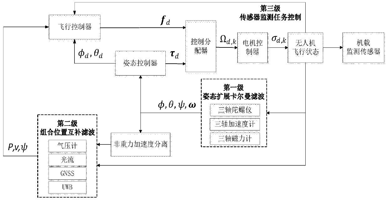
[0094] The present invention will be further described below in conjunction with the accompanying drawings. The system follows the steps below to detect the condition of the bolts at the bottom of the bridge:

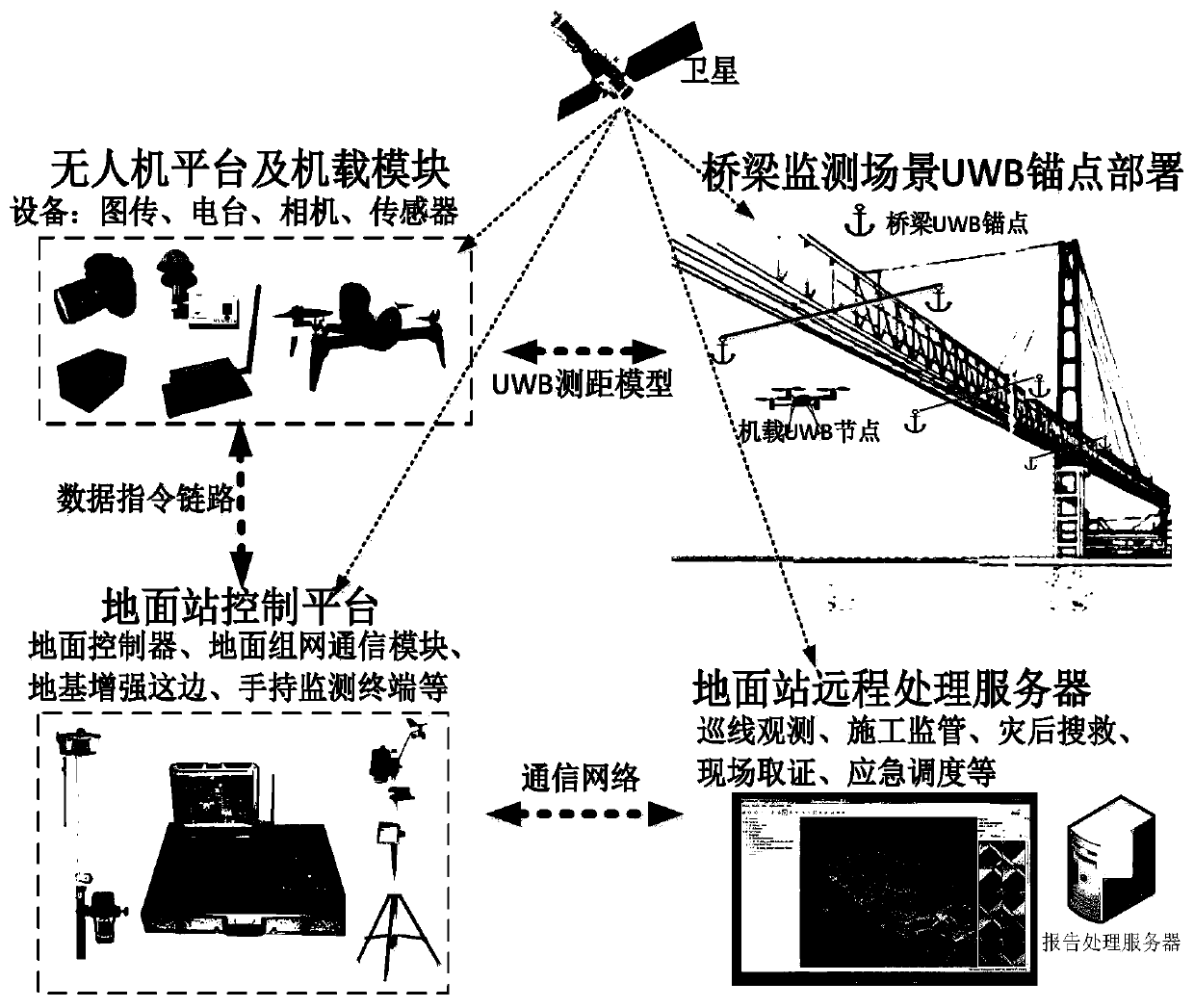
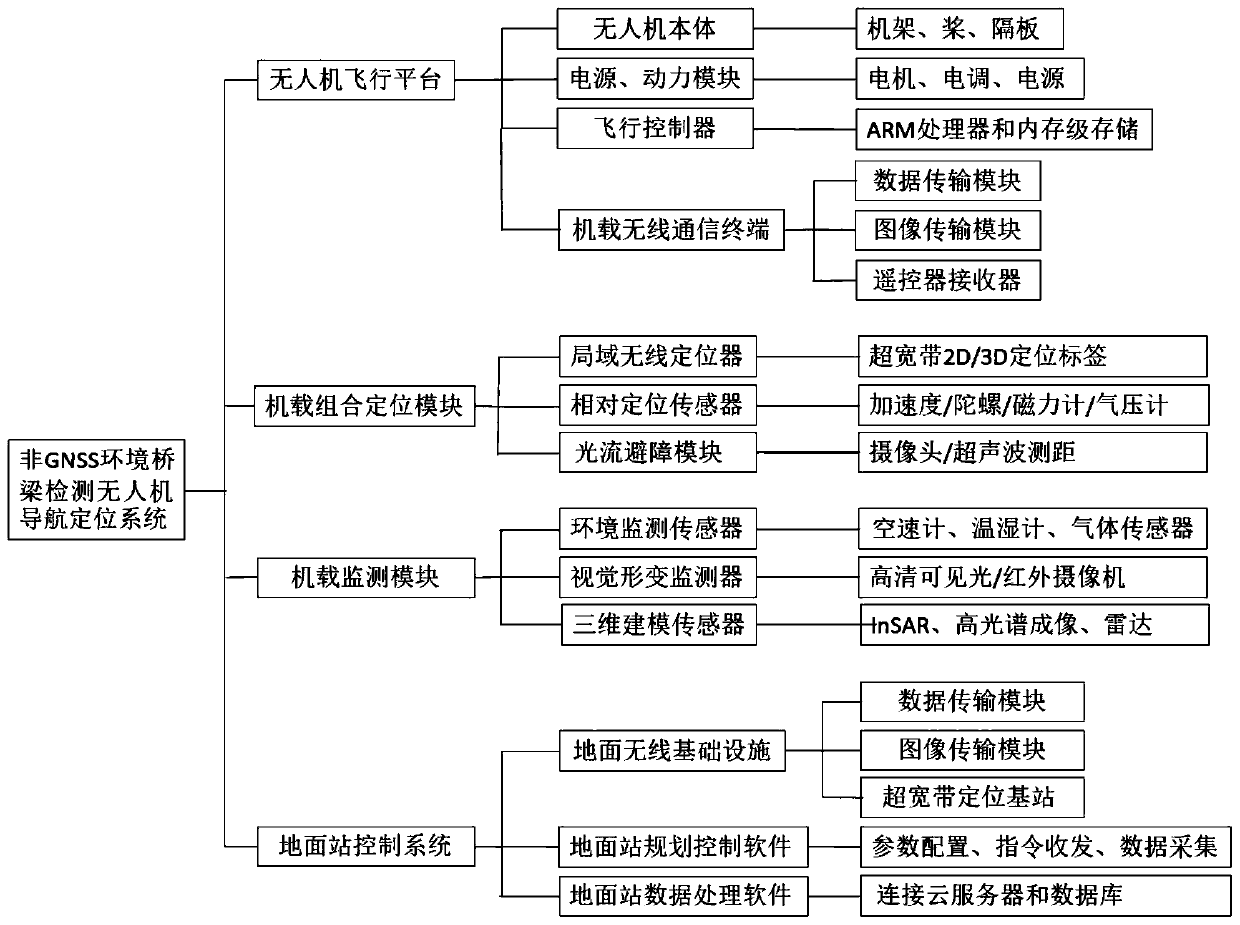
[0095] Step 1, fix the four UWB base stations on both sides of the bridge with carbon fiber poles, and ensure that the drone flies within the range of the four anchor points. Preset the position coordinates of the four base stations in the ground station software.

[0096] Step 2. According to the judgment of light and shade, choose to place a high-definition camera on the drone. In order to detect the condition of the bolts at the bottom of the bridge, a high-definition camera and radar were chosen to be placed on top.


PUM


Abstract

The invention discloses a bridge detecting unmanned aerial vehicle system in a non-satellite navigating and positioning environment. The bridge detecting unmanned aerial vehicle system comprises an unmanned aerial vehicle flight platform, an airborne combined positioning module, an airborne monitoring module and a ground station control system, wherein the unmanned aerial vehicle flight platform comprises an unmanned aerial vehicle body, a power supply, a power module, a flight controller and an airborne wireless communication terminal; the airborne combined positioning module comprises a microinertia measuring unit, an ultra-wideband navigating and positioning module, an optical flow measuring module and a barometer; the airborne monitoring module comprises an airborne environment monitoring sensor, a vision sensor and a radar sensor; and the ground station control system comprises a wireless ground infrastructure, ground station planning control software and ground station data processing software. The bridge detecting unmanned aerial vehicle system adopts an integrated navigating and positioning way based on UWB, MIMU, OF and RAR, improves the positionability and the navigatingand positioning accuracy of an unmanned aerial vehicle in a global satellite navigating and positioning environment, and preforms close-distance obstacle observation in a complex bridge environment through the optical flow module.

Description

technical field [0001] The invention relates to the technical fields of bridge detection and unmanned aerial vehicle navigation and positioning, in particular to a bridge detection unmanned aerial vehicle system in a non-satellite navigation and positioning environment. Background technique [0002] In recent years, my country's transportation construction has developed rapidly, and large-scale bridges have been completed one after another. my country accounts for more than 50% of the global long-span bridges. The health detection of bridges is related to the safety of transportation and the safety of people's lives and properties. The current commonly used detection methods are manual visual inspection or the use of bridge inspection vehicles, both of which have certain limitations: manual visual inspection will have problems such as detection blind spots and low monitoring efficiency, while using bridge inspection vehicles is expensive, poor in mobility, and affects the u...

Claims


Application Information

Patent Timeline
Patent Type & Authority Applications(China)
IPC IPC(8): B64C27/08B64D47/08E01D19/10G05D1/08G05D1/10
Inventor 阳媛张晶晶戴鹏李艺璇樊佛莉鲍小雨
Owner SOUTHEAST UNIV
Why Eureka
Try Eureka