
Cloud+ terminal positioning service method and system

A positioning service and cloud server technology, applied in the field of cloud + terminal positioning service methods and systems, can solve the problems that the positioning accuracy cannot meet the measurement and mapping, the accuracy cannot reach the accuracy better than one meter, and reduce data processing and communication resources. Stress, the effect of saving communication costs

Active Publication Date: 2019-06-28
UNICORE COMM INC +1
View PDF10 Cites 11 Cited by
  • Summary
  • Abstract
  • Description
  • Claims
  • Application Information

AI Technical Summary

Problems solved by technology

Since the comprehensive influence of satellite orbit and clock error and atmospheric propagation error exceeds the meter level, although the orbit clock accuracy of each satellite navigation system is continuously improving, and more and more satellites are available, the standard unit without the support of external precision data The accuracy of SPP (Standard Point Positioning) has never been better than one meter
The above positioning accuracy cannot meet the requirements of surveying and mapping, precision agriculture, unmanned driving and other industries that require centimeter-level, decimeter-level, and sub-meter-level precision

Method used


Image

  • Cloud+ terminal positioning service method and system
  • Cloud+ terminal positioning service method and system
  • Cloud+ terminal positioning service method and system

Examples


Embodiment Construction

[0021] Embodiments of the present application will be described in detail below in conjunction with the accompanying drawings. It should be noted that, in the case of no conflict, the embodiments in the present application and the features in the embodiments can be combined arbitrarily with each other.

[0022] The steps shown in the flowcharts of the figures may be performed in a computer system, such as a set of computer-executable instructions. Also, although a logical order is shown in the flowcharts, in some cases the steps shown or described may be performed in an order different from that shown or described herein.

[0023] In order to weaken the errors that affect the accuracy of satellite positioning, precision data can be used to improve positioning accuracy. Among them, different positioning modes can be adopted according to different precise data, for example, Satellite Based Augmentation System (SBAS, Satellite Based Augmentation Systems), Differential Global Nav...


PUM


Abstract

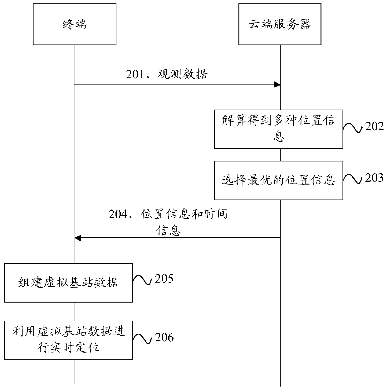
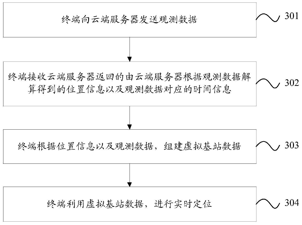
The invention discloses a cloud+ terminal positioning service method and system. The method comprises: a terminal sending observation data to the cloud server; the cloud server obtaining at least twokinds of position information through calculation according to the observation data and precision data collected by the cloud server, and selects optimal position information from the position information; the cloud server returning optimal position information to the terminal and calculates time information corresponding to observation data adopted by the optimal position information; and the terminal establishing virtual base station data according to the position information and the observation data, and performs real-time positioning by using the virtual base station data.

Description

technical field [0001] This application relates to but is not limited to satellite positioning technology, especially a cloud + terminal positioning service method and system. Background technique [0002] At present, there are five GNSS (Global Navigation Satellite System) widely used in the world, namely the Global Positioning System (GPS, Global Positioning System) of the United States, the GLONASS Satellite Navigation System (GLONASS) of Russia, and the Global Positioning System of China. Beidou satellite navigation system (BeiDou), the European Union's Galileo satellite positioning system (Galileo) and Japan's quasi-Zenith Satellite System (QZSS, Quasi-Zenith Satellite System). A variety of satellite navigation systems can jointly provide positioning services for users, thus greatly improving the availability, reliability and accuracy of satellite positioning technology. Satellite positioning technology has been widely used in many fields such as vehicle navigation, su...

Claims


Application Information

Patent Timeline
IPC IPC(8): H04W4/02H04W64/00H04L29/08G01S19/42
Inventor 陈孔哲
Owner UNICORE COMM INC
Learn More